
GroundWinds
GroundWinds is a technology demonstration project for a prototype spaceflight instrument that would provide global wind data.
The University of New Hampshire, Michigan Aerospace Corporation, and Mount Washington Observatory are currently operating a new type of wind sensor in the Mount Washington Valley. This project known as GroundWinds, measures winds from the ground up to around 40,000 feet by using a lidar system.
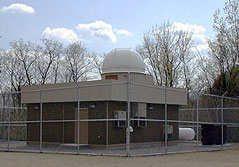 IMAGE: Research includes studies of clear air turbulence, cloud and aerosol influences on climate, severe weather forecasting, and air quality.
Lidar is actually an acronym for “LIght Detection And Ranging.” It can be thought of as a laser radar. Radar utilizes radio waves to make its measurements, as opposed to lidar, which uses laser light.
A basic lidar instrument is made up of a laser source, telescope, and detection system. A laser pulse is emitted into the atmosphere, scatters off of the air molecules and aerosols and returns through the telescope system. The detection system collects the light, and analyzes the data to determine the wind velocity, air temperature, and air density.
 IMAGE: 532nm 5W 10Hz Pulsed Laser Beam
For the detection system to analyze the data, the Doppler effect is used. The Doppler effect is characterized by a change in wavelength (and frequency) of a wave due to the motion of either the source or receiver of the waves.
In a lidar system, the laser light which is characterized by a light wavelength, experiences this wavelength shift as the light scatters off of the moving air molecules or aerosols in the atmosphere. By comparing the incoming and outgoing laser pulses, you can determine the magnitude of the Doppler shift, and convert this into a velocity number.
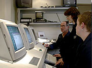 IMAGE: Phil Dunphy, UNH, Jane Pavlich, MAC, Michelle Day, MWO
Currently, the wind data used by national forecasting offices around the world come from just 900 stations. These stations are concentrated in the mid latitudes and coverage over the oceans is limited to the few island nations that launch weather balloons.
With the successful demonstration of GroundWinds, satellites equipped with lidar technology can collect wind speed and direction for the entire planet. The additional data will significantly improve weather forecasting, bringing the same level of accuracy to the 5-7 day forecast as currently exists in the 2-3 day forecast.
More importantly, however, is the positive impact that better wind data will have on our ability to predict the path of hurricanes, the development of Nor’easters, and other extreme weather events.
