
1 to 9
2010-07-13 20:07:55.000 – Ryan Knapp, Staff Meteorologist

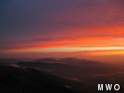
Sunset 07-10-10 over LaFayette.
If you read our recent E-blast, you may have seen a link to a set of sunset pictures for July 10, 2010. In the segment, an unknown source was quoted as calling it the “best sunset ever.” While none of the observers would call it the “best ever” (it was lacking an undercast, lower clouds, etc), it was still a very nice sunset. What made it memorable though was the way it all came about. In past comments, we have mentioned that we give each sunrise/set a rating of 0-10 (10 being best). Early on that afternoon, we were looking at the intermittent fog, the haze and the clouds above and giving it a 1 rating as it was a sea of gray. An hour later, a bit of color was showing and we upped our rating to a 4 but still nothing to really disrupt dinner over or write home about. But right around dinner, the sky exploded with color in all directions and it easily became a 9 (in my opinion). So, we changed our sunset rating “forecast” from our lowest rating of 1 to a moderate 4 to a high of 9 (out of 10); kind of like when a kid gets an “F” on a test and ever so carefully changes the “F” to a “B” or an “A” before taking it home.
Forecasting the sunset that afternoon kind of felt like forecasting the weather at times this past week where we said the weather would be one way (a “1” of sorts) only to have it wind up being the complete opposite (a “9” if you will). The culprit that’s been causing us such a forecasting headache: a semi-tropical air mass over the northeast. For nearly the entire month of July, a southern air flow has been pumping a warm (sometimes hot) and humid air mass into New England. If you live in New England, this should come as no surprise as the muggy and sometime oppressive weather has been very noticeable most days. On the summit, it has been cooler than the surrounding valleys but even for summit standards, it has been warm and muggy. But that is not where the problem in forecasting has occurred. The problem with the warm and humid weather is the clouds/fog, showers, and thunderstorms this type of air mass helps produce.
With a warm and moist air mass like this, convective activity has been running in overdrive. Passing fronts have been exploding with heavy rain showers and severe thunderstorms. And even the weaker fronts that would normally just bring some fair weather cumulus have been exploding into rain showers or thunderstorms. And in between these frontal passages, orographic lifting has been generating clouds/fog, showers and occasional thunderstorms on a nearly daily basis. As the warm, moist air from the valleys below is forced up the mountains, adiabatic cooling occurs resulting in clouds forming either just above us or below us but towering above us. This results in one of two errors. The clouds that form just above keep us fog free but make the skies cloudier than I forecasted. Or, the clouds just below towering above slam into us bringing more or less fog that I didn’t forecast. But even then it isn’t a constant fog. As the air passes us, it begins to sink and dry out. This means the side of the mountain where the wind is coming from is in the fog while the leeward side of the mountain is usually clear or intermittently in the fog. But we aren’t the only mountain forcing this to occur. So when we are clear, orographically induced clouds are everywhere. And if conditions are just right, these clouds build and become showers or thunderstorms for the leeward summits and valleys. Then as the sun sets, these orographically induced clouds burn off keeping us mostly fog free only to start up again hours after sunrise the next day.
So as I get ready to head down for my off week tomorrow, I looked at what I should be expecting especially since I have a few day hikes in mind. And since I try and keep my same schedule on my off weeks, I wanted to see if sleeping during the day would be possible. But looking ahead during this coming off week for me, there is little to no major changes expected in the weather pattern. The tropical air mass will remain and with it, a tropical-like weather pattern. This means the White Mountains and surrounding valleys will continue to be warm and humid with nearly a daily occurrence of clouds with isolated showers and thunderstorms. So with this in mind, I guess I will have to be “normal” this off week and reverse my sleeping habits so I can sleep in the cooler night time hours and wake up early to knock out my hikes before the unsettled and uncomfortable weather each afternoon.
Ryan Knapp, Staff Meteorologist

Seek the Peak Spotlight: The Cloud Chasers
Seek the Peak Spotlight: The Cloud Chasers By MWOBS Staff Mike Bergeron and Desiree Bolton have been participating and volunteering for Seek the Peak for three years now. Together, they comprise Team Cloud Chasers

Celebrating 250 Years: The Declaration’s Legacy in the White Mountains
Celebrating 250 Years: The Declaration's Legacy in the White Mountains By Peter Crane We are now approaching July Fourth, Independence Day, the day when we celebrate the adoption of the Declaration of Independence in

Seek the Peak Spotlight: Ryan Shepard
Seek the Peak Spotlight: Ryan Shepard By MWOBS Staff Before Ryan Shepard moved to Conway, he was in Western New York celebrating his 40th birthday party. “I wanted to go big,” he said. “Big”
