137
2009-11-28 22:36:24.000 – Mike Carmon, Staff Meteorologist
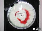
Now that’s a good looking Hays Chart!
Good things come to those who wait!
or
Be careful what you wish for…
All of you avid followers of our observer comments are probably intimately familiar with the tame November we’ve been experiencing on the summit. Every day since November 8th has seen temperatures averaging above normal, and up until yesterday, we had experienced a mere 4.3″ of snow. This past Wednesday (November 25th), we were able to ride all the way to the summit in the 4-wheel drive van without the use of chains! We all wondered–when would winter arrive?
Arrive it would, and it was revealing its planned return in the forecast models since early this week. On Wednesday, the long range models indicated “94 kts” for wind speed on Saturday, which is approx. 108 mph. Generally, when winds are sustained this high, gusts are much higher, potentially reaching 120-130 mph. To make a long story short, these numbers were very exciting, but also taken with a grain of salt, as a lot can change in four days.
Change they did. As Thursday progressed, the shorter-range models began to pick up on the potential monster storm, but forecasted wind speeds took a steady downward trend with each model run, which disappointed us all. However, snowfall potential looked excellent-Stacey was fully expecting at least 10″, while I took a more conservative view, figuring about 6-8″. Either way, it looked to at least double what November had brought us to that point.
On Friday, the wind speed forecast numbers took a bit of an upward trend, but were still nowhere near the impressive numbers we had seen on Wednesday. The snow was a different story, however. Moderate to heavy snow fell all day, dumping 14” by 7 p.m. and another 5” or so by 1 a.m., with snow still falling. I was forced to swallow a bit of my forecasting pride, as I vastly underestimated the snowfall potential of this system. But after this unexpected surprise, we were all hoping the winds would give us a nice surprise as well.
About midnight, I took a look at the latest model runs, and could not believe my eyes. Before me were the highest wind speed forecast numbers I had seen since beginning work here in August 2008. Both models were in excellent agreement that just before daybreak, winds would max out around 105 mph!
From midnight to 3 a.m., winds averaged about 65 mph and gusted into the 90s. Suddenly, just after 3 a.m., a switch was flipped somewhere in the atmosphere, as wind speeds catapulted into the 80s, and gusted to 118 mph! I was trying to get my work done, but it just was not happening. I was listening to the howl of the winds (which morphed into an earsplitting roar), feeling the floor shake beneath me, and experiencing the transformation of snow flakes and rime feathers outside into tiny darts traveling at super-hurricane speeds and smashing into the weather room windows.
Because of the northwest direction of the flow, the observation deck was feeling the full force of these winds. Inside the protective walls of the tower, one could hear the ominous growl, but opening the tower door revealed a roar louder than anything I have ever experienced in my lifetime. Combine that with the dark of night and visibility of about 25 feet, and it was truly something special to experience!
Around 5:20 a.m., Steve and Mary Ellen had awoken, and the morning transformed into a Hays Chart-watching session. We were all getting excited about each gust and hoping it would be surpassed by the next. Just before 5:25 a.m., the winds lulled to about 90 mph, then unexpectedly, an incredible roar jolted the building. I bolted to the Hays Chart to discover a reading of 9.8” (nearly off the chart), which converted to 137.4 mph! For the second time during the evening, I couldn’t believe my eyes! In the picture above, note the 5-6 AM hour (at the bottom of the chart). You can clearly see the 137 gust, which is the line that extends furthest away from the center, nearly extending to the edge of the chart.
Amidst these formidable winds, 24.4” of snow fell on Friday and early Saturday, and has been blown about all day. By now, much of it has made its way down the summit cone and into Tuckerman Ravine.
As of this time, it looks like the 137 gust will be our peak for this storm. It is a personal record for Steve, Mary Ellen, and I, and also Mt. Washington’s peak for 2009 thus far (defeating the previous peak of 132 mph on New Year’s Day). In fact, it is the strongest wind gust since a crest of 145 mph on March 21st, 2008.
So when I venture to the top of the tower to de-ice and hold on for dear life as I swing a crow bar and dodge the flying pieces of rime, or trudge through 4 foot drifts to get the precipitation can while 100 mph winds are shoving at me, or attempt to hold up a felt board while clinging to the A-Frame to try and determine whether or not it is snowing, I ask myself…would I have it any other way?
The answer…not in a million years!
Mike Carmon, Staff Meteorologist
Three and a Half Months of Snow, Ice and Rime
Three and a Half Months of Snow, Ice and Rime, with Deeper Drifts. By Ryan Steinke Me outside on the summit near the Yankee Building. My internship with the Mount Washington Observatory
Supporter Spotlight: Righteous Vices Coffee Roasters
Supporter Spotlight: Righteous Vices Coffee Roasters By MWOBS Staff Righteous Vices Coffee Roasters, a local coffee roaster and shop located in Center Conway, New Hampshire, has been a partner of the Observatory since 2024.
Winter Storm Tracks Across New Hampshire
Winter Storm Tracks Across New Hampshire By Alex Branton As winter comes to a close, most of us are ready for the warmer temperatures and sunshine that come with Spring and Summer. Although we


