
6 inches of new snow!!!!!
2007-01-09 08:26:37.000 – Jim Salge, Observer

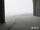
Snow drifts at the front door…
Finally, some normal wintry weather has arrived on Mount Washington. Snow, sleet, freezing rain, freezing fog, high winds and COLD temperatures. All these conditions and more arrived yesterday, and look like they will hold for through the week now. The staff is on their way out the front door with shovels for the first time in a while, to remove the rather large drifts that have built up. All this from the storm that dropped a bit over 6 inches on the summit.
And the summit needed it, after last week’s warm up we were looking a little bare…see pictures:
These pictures were taken the new Bretton Woods Cam just two days ago.
A view from this new camera will launch on our website at the end of our new membership drive, which at the current pace may be soon. All it takes for this camera to be brought online is your new Observatory membership. And were 15% of our way to our goal in just one week! Your support goes towards operation costs at the summit, research on our climate record, outreach education, and sustaining the content on this website.
Lastly, and in other (now old) news, the CBS Evening News was up on the summit yesterday to film a storm on the warm weather all across and above New England. It will air tonight, we hope you will tune in!
*UPDATE: Here is a link to the CBS story that aired last night!
Jim Salge, Observer
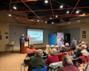
Watch Our 2026 Annual Meeting and Read About the Highlights
Watch Our 2026 Annual Meeting and Read About the Highlights By Drew Bush United States Representative Maggie Goodlander headlined Mount Washington Observatory’s 2026 Annual Meeting, and she set the tone right from the start.
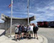
Seek the Peak Spotlight: The Middleton Family
Seek the Peak Spotlight: The Middleton Family By MWOBS Staff Every summer, the White Mountains offer no shortage of reasons to get outside. Trails stretch in every direction—endless miles of terrain, summits that each
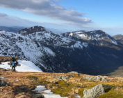
Lots of Digging, but Never Enough
Lots of Digging, but Never Enough By Ryan Tanski Over the past four months, I had the privilege of working with the Mount Washington Avalanche Center and Mount Washington Observatory, deepening my understanding of
