The Story Behind a Tumultuous Transition to Spring
Francis Tarasiewicz, Weather Observer & Education Specialist
April ended on an active and destructive note for the summit and New England as a powerful area of low pressure delivered flooding rains and damaging winds. To add insult to injury, May led a follow-up act that featured an all-star cast of heavy snow, graupel, and hail on the summit.
Let’s explore the science and story behind a violent late-season storm and tumultuous transition into spring.
Thanks to dozens of weather observers around the Northeast, we are able to get a sense of the storm’s water footprint. The map below shows the amount of liquid precipitation that accumulated over the course of the day on April 30. For many locations, the storm dropped between 1 and 3 inches of new rainfall.
It was a much wetter story across large portions of Maine where storm total rain amounts ranged from 3.5 to 6 inches! For many parts of Maine and northern New Hampshire, this storm brought a month’s worth of rain within a single day.
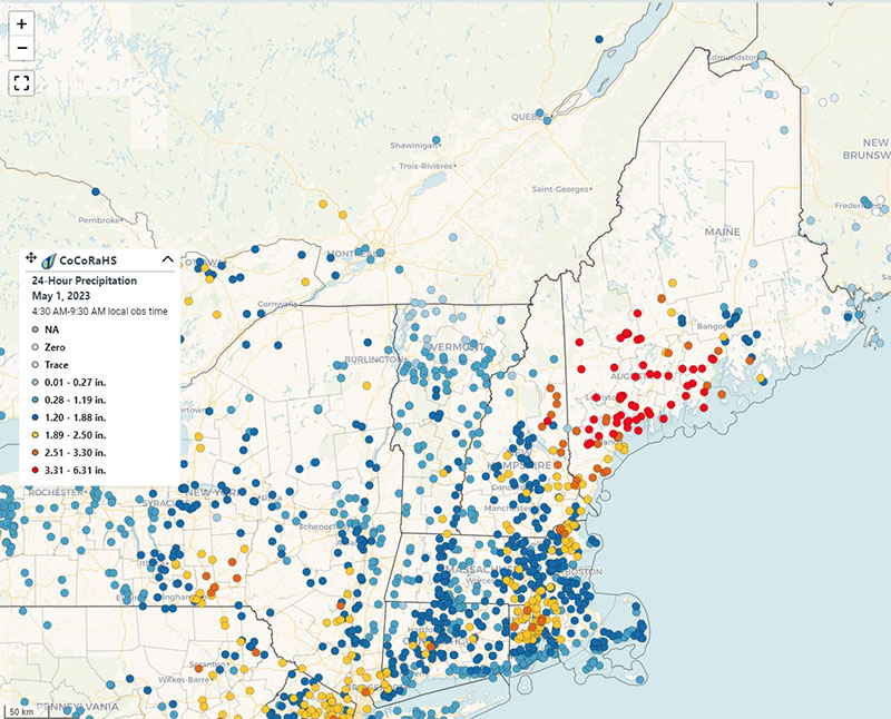
Up here on the Rockpile, observers measured 3.1” of rainfall when all was said and done. This amount was much lower than some computer model projections, which showed a widespread 7-10” of rainfall on eastern-facing slopes. This lower amount was due in part to some localized rain shadowing. A larger share of the credit for this discrepancy can be attributed to another factor: the type of precipitation that was falling.
For 23 hours, the summit experienced a relentless onslaught of freezing rain. For us observers, this translated to a grueling period of de-icing feet of glaze ice per hour. On a lighter note, I got a chance to feel like a glazed doughnut.
A patch of low-level cold air pushed from the Northeast from an area of high pressure was very slow to leave. In fact, this patch of below-freezing air stuck around for a much longer time than we initially expected. Outside of making for a hazardous albeit beautiful wintry scene, the wide layer of accumulated glaze ice on the snowpack set the stage for the creation of a non-permeable surface.
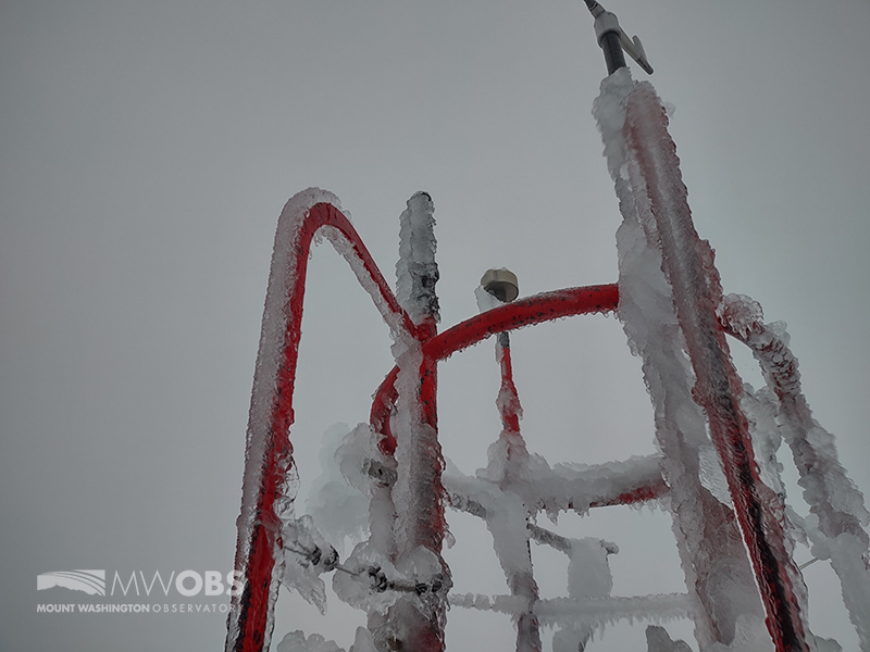
Significant glaze ice accumulates on the instrument tower on April 30.
Temperatures finally warmed above freezing late on the night of April 30. The unfortunate aspect of this was that they only warmed to around 34 degrees. This meant that while it was warm enough for heavy rain and thunderstorms, it was not warm enough to melt the thick ice layer on the surface. This temporary ice luge sent copious amounts of water from the summits into the surrounding valleys with locally disastrous results for entities that operate on the summit.
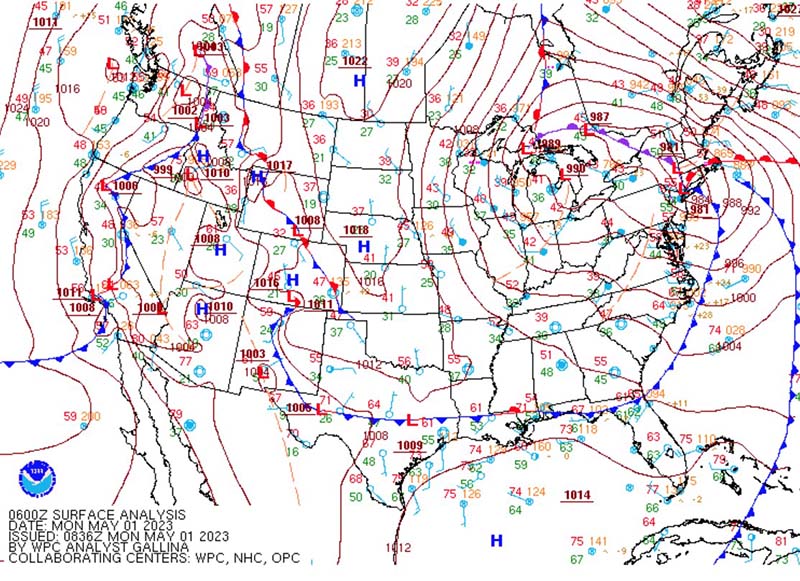
This surface map shows the low pressure at its strongest early on May 1.
As you may have seen online, the sheer volume of water unfortunately resulted in significant damage on a quarter mile stretch of the Mt. Washington Auto Road between Six Mile and Green Pipe. In some areas, water scoured down to bedrock.
I need to give a tremendous shout-out to the Auto Road team for their successful efforts in not only repairing the road but also being able to open in time for May 13 (their originally planned opening date). Take it from me, working on the top of New England is not easy and so their feat is even more impressive.
The storm eventually let up on the morning of May 1. However, as I and the summit crew realized, this was merely a break before part two arrived. For days, we were focused on the flooding rainfall potential, and while that caused some very apparent problems, we were almost entirely unprepared for what was to come next.
As the low pressure moved westward against meteorological conventions for the northern Hemisphere, it was captured by an unseasonably strong upper-level low pressure system. Embedded within this upper-level low (around 18,000 feet) was a pocket of -22°F air pin-wheeled from the upper Great Lakes. All systems were a go for the storm to enact its revenge.
To elaborate more on that cold air (after all, you may be wondering why I am obsessing about temperatures that are three miles above us), let me nerd out for a minute about lapse rates. As discussed in Karl Philippoff’s recent blog, lapse rates are a very important component in Earth’s weather and climate systems. Simply put, lapse rates are a measure of the rate of change in temperature as you go up into the atmosphere. The typical lapse rate of a dry atmosphere averaged around the world is about 6.5 °C per 1000 feet.
On May 2, the lapse rate was nearly 8.7 °C! This meant that the atmosphere was very unstable, and that any warmer parcel of air near the surface would quickly rise due to buoyancy, form clouds, and then precipitation. To make matters better for precipitation formation, an east wind off of the Atlantic acted to funnel moisture up and over the summits where it formed into clouds that dumped FEET of snow.
Snow wasn’t the only form of precipitation that fell on the summit during winter’s final stand. In addition to large and wet snowflakes, the atmosphere dropped a smorgasbord of other precipitation. The precipitation mode that brought the heavy snow was convective. This means that the processes that form thunderstorms, namely convection, were at play in producing these heavy snow showers. Unsurprisingly, we observed precipitation types reserved for convective activity. Over the course of nearly two days, we witnessed ice pellets, snow grains, graupel, and hail!
To see hail alongside snow was an experience that I wont soon forget. The hail that fell was far short of the golf and even tennis ball-sized hail that falls from Mid-Western supercells. It was more like small jawbreakers that shattered as it hit the ground. When all was said and done, summit observers measured 20.2” of snowfall, far above the average 12.9” that coat the summit during the month of May.
While impressive, the timing of the snow presented a pretty large operational hassle for our shift change. Recall that at the time, a sizeable portion of the Auto Road was washed out. I may not have to explain this, but roadwork and heavy snowfall don’t typically mix very well. So the question quickly became, how are the observers getting off of the summit this week? Enter the Cog Railway!
After some planning and discussion, the Cog offered to provide transportation to the observers. The journey, however, was anything but easy. With an easterly wind, snow was able to more readily pile onto their tracks. This meant a slow journey led by a gargantuan snow blower. Imagine the biggest snow blower that you may have. Perhaps it’s worthy of storms like the blizzard of 2013. Now multiply its size by 10 to get a sense of the size of the blower that freed the observers.
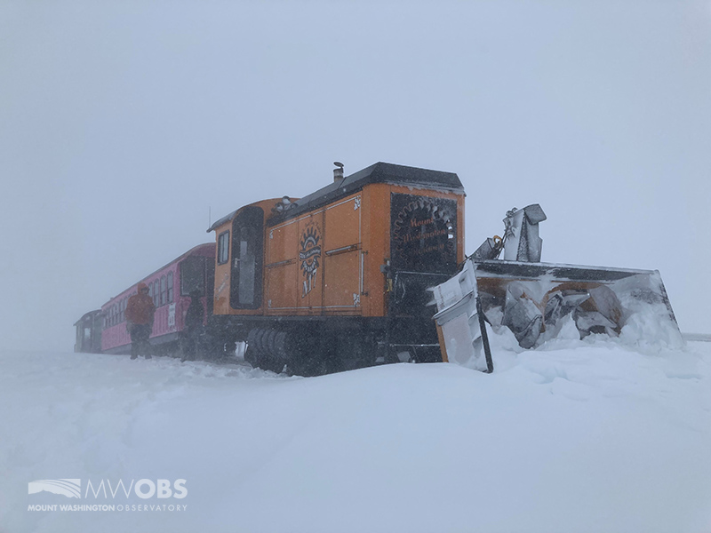
The Cog Railway train with snow blower out front.
Even still, the sheer amount of snow resulted in a stop-and-go snails pace up to the summit. At times, the snow gummed up the blower forcing the brave operators to weather the elements with shovels to clear any blockages. Thank you again to the hardworking team at the Cog for successfully getting us down safely.
Storms like this one, while challenging and at times frustrating, are the reason we are up here. Through our observations, we were able to get a glimpse into the dynamics of a rare and damaging event. This storm also highlighted the importance of our ongoing research into local lapse rates, and how they can make or break a forecast. And in the midst of driving winds, rain, and snow, the importance of partnerships shone through.
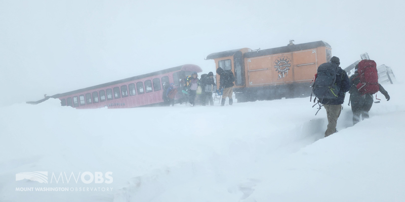
Summit staff and volunteers load and unload gear during shift change on May 3.
Francis Tarasiewicz, Weather Observer & Education Specialist
Living the Night Life
Living the Night Life By Madelynn Smith My alarm goes off in the bunkroom, with blackout curtains obscuring the sun’s rays as it begins to lower in the sky. My day starts in the
Three and a Half Months of Snow, Ice and Rime
Three and a Half Months of Snow, Ice and Rime, with Deeper Drifts. By Ryan Steinke Me outside on the summit near the Yankee Building. My internship with the Mount Washington Observatory
Supporter Spotlight: Righteous Vices Coffee Roasters
Supporter Spotlight: Righteous Vices Coffee Roasters By MWOBS Staff Righteous Vices Coffee Roasters, a local coffee roaster and shop located in Center Conway, New Hampshire, has been a partner of the Observatory since 2024.


