
Going with the Flow: Why New England Didn’t Experience Any Classic Nor’easters This Winter
By Peter Edwards
Why didn’t the Northeast experience any major snowstorms this year?
If I had to guess, it’s the million-dollar question that meteorologists, winter recreationists, and snow lovers alike have been asking. On paper, it looked like we had plenty of opportunities for a Nor’easter to develop. The eastern U.S. experienced several sustained intrusions of bitterly cold Arctic air during the climatological peak for snowstorms, December through February. These outbreaks were accompanied by another key ingredient: deep longwave troughs. When these troughs drop into the mid-latitudes the stage is often set for the development of extratropical cyclones—and more specifically Nor’easters.
But every time a promising Nor’easter appeared on long-range model guidance, it would trend weaker and track farther south as the event approached. Instead of burying the Northeast, several systems dumped more snow on parts of the Mid-South, Southeast, Gulf Coast, and Mid-Atlantic than on New England. In some cases, areas like Tennessee, northern Georgia or even Louisiana and Florida saw higher single-day snow totals than areas of the northeast.
So what went wrong?
The answer lies mostly in the orientation and behavior of the Polar Jet Stream, and how it directed storm tracks away from New England this winter.
The Jet Stream and Nor’Easters
To understand what happened, we first need to talk about the Polar Jet Stream.
The Polar Jet is a fast, narrow current of air in the upper troposphere (~30,000 feet above sea level) that forms along the boundary between cold Arctic air and warm subtropical air. Think of it as a high-speed atmospheric highway that guides the movement of weather systems across the mid-latitudes.
Most of the time, the jet stream flows from west to east in a relatively straight line. This is called a zonal flow. In this regime, cold air is mostly confined to the poles, and milder air dominates the mid-latitudes.
But sometimes the jet becomes more amplified, transitioning into a meridional or “wavy” flow pattern. When this happens, large ridges and troughs develop, and the jet can meander far north or south. These undulations are crucial for major winter storms. For example deep trough digging into the eastern U.S. can drag Arctic air southward and create the right conditions for cyclogenesis off the East Coast. This is a classic setup for a Nor’easter.
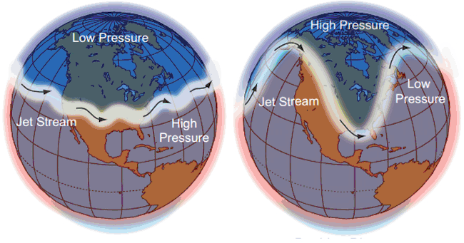
The image on the left is an example of the polar jet stream while it is in zonal flow. The image on the right is an example of the Jet stream when it is in meridional flow. In the image on the right the dips in the jet stream represent troughs and the arches represent the ridges. (Source: Unknown)
Why The Jet Stream Ended Up In the Wrong Location
This winter, we did see a wavy jet but it wasn’t wavy in the right places.
A persistent ridge of high pressure off the west coast of the U.S forced the downstream trough too far west. This setup displaced the storm track southward through the central or southeastern U.S., preventing storms from intensifying near the New England coast. Instead of classic Nor’easters riding up the coastline, many systems stayed suppressed or slipped out to sea before they could fully develop. The ideal position for this ridge of high pressure is when it is sprawled out over the western U.S, not the Pacific.
The result? Cold air in place but no storm phasing. A season of near misses.
Case Study: 1/20/25 Miss vs. 1/29/22 Nor’easter
Perhaps the best way to understand this is to examine the structure of the upper air patterns from a past winter that supported an east coast snowstorm and this most recent winter. We’ll first look at the pattern that supported east coast snow and then compare it to the predominant pattern that we had this winter to see the subtle yet impactful differences.
First we have to go all the way back to 2022 when the last major Nor’easter came up the east coast during the winter and impacted New England. Looking at the pressure patterns in the upper atmosphere we can see a large ridge of high pressure in the lighter shading that built over the Western U.S. and the deep trough over the Eastern U.S in the darker shadings: That ridge forced the trough and the cold air it brought with it to more sharply dig south into the Eastern United States.
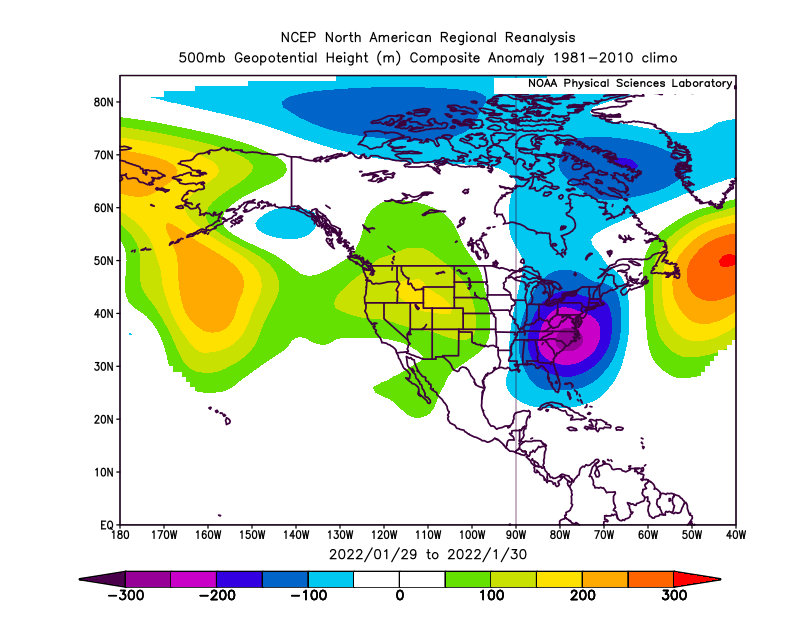
On the western half of the U.S we can see the ridge in yellow, orange and green shading centered over Idaho and Wyoming. In the Eastern U.S the trough is shaded in blue and purple. (Source: NOAA Physical Sciences Laboratory)
Now we can examine the pattern in the jet stream. In fact, by tracing up and around the ridge then down along and around the bottom of the trough we can actually sketch a rough outline of the jet stream. With the ridge placement centered over the western U.S in this fashion it caused an undulation in the jet stream forcing a meridional flow out east. This allows the storms to move south to north along the coast which gives it more time to strengthen in a favorable environment.
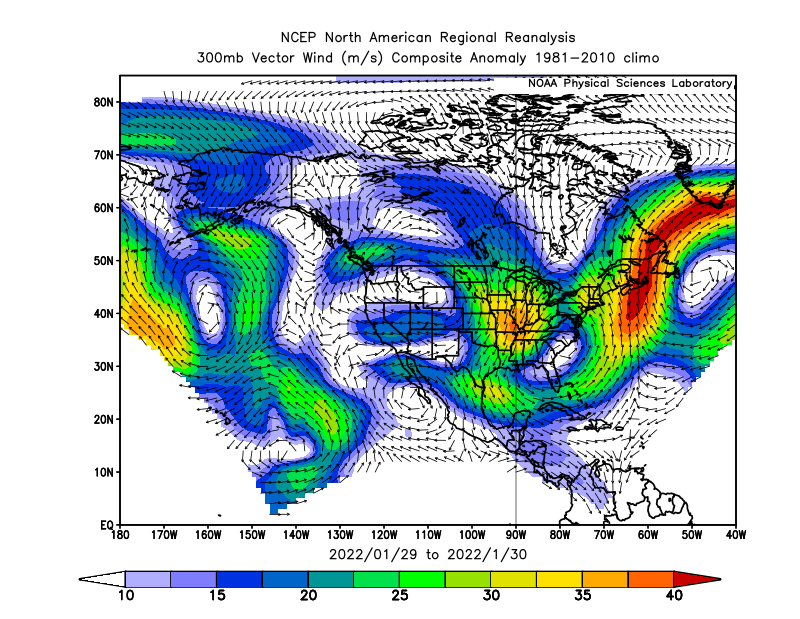
Off the east coast a strong south to north or meridional flow of the jet stream is illustrated by the darker red shading. (Source: NOAA Physical Sciences Laboratory)
The result was an area of low pressure forming off the southeast coast that strengthened into a powerful cyclone with a central pressure of 975mb as it climbed the coast, blanketing New England in snow.
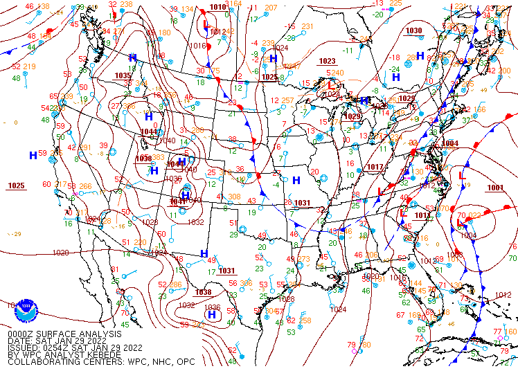
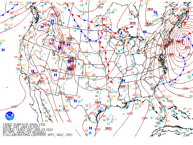
The evolution from a broad and weak area of low pressure to a well organized nor’easter as it made its journey up the Eastern seaboard on January 29th of 2022. (Source: Weather Prediction Center)
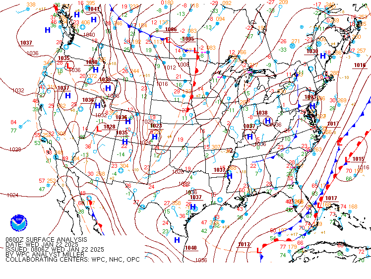
Now that we’ve discussed what a favorable pattern for storm development looks like we can examine the differences in this year’s pattern. What stands out is that the ridge is not over the western U.S but instead, out over the Pacific Ocean. This pattern is great at dropping a trough and cold air into the U.S but without a ridge dominating the Western half of the country the trough gets displaced further West and is much broader.
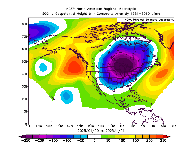
Upper air pressure patterns for January 20th 2025. This setup produced record snowfall amounts in multiple states along the Gulf Coast.
Now that we’re examined an example of the upper level pressure patterns for this year we can take a closer look at the Jet Stream and come to a conclusion: The biggest difference is that the Jet Stream orientation was tilted southwest to northeast. This guided the storms out to sea well to our south while giving them little time to strengthen. Looking out west, instead of weak anticyclonic flow highlighted in the first example, strong northerly upper level winds dominated the western half of the U.S.
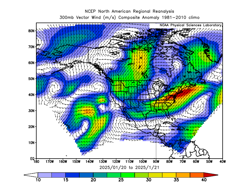
The orientation of the jet stream was tilted southwest to northeast. A jet stream that sets up this way is unfavorable for snow storms in the northeast. (Source: NOAA Physical Sciences Laboratory)
This particular set up was so extreme that it produced record snowfall amounts along much of the Gulf Coast. Even though this setup was the most extreme, the rest of the winter exhibited similar behavior. The area of low pressure in this case started in the western Gulf of Mexico before moving over Florida and out to sea, remaining quite weak. As a side note, this small area of low pressure traversed the entirety of the Atlantic, turning into Winter Storm Eowyn which brought extreme impacts to Ireland and other parts of the U.K.
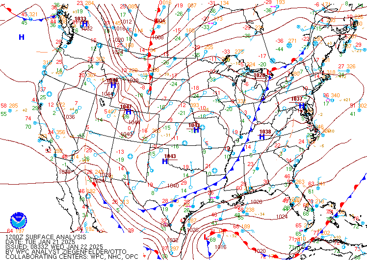
Initial development over the Gulf and Florida before heading out to sea. (Source: Weather Prediction Center)
So Why Did the Pattern Persist?
The even deeper question is why did the pattern set up this way over and over again? It’s a bit more complicated, but it likely has something to do with the base state of the El Nino Southern Oscillation (ENSO). ENSO is global climate driver that emerges from variations in wind and sea surface temperatures in the tropical Pacific Ocean. As we headed into the fall of 2024 we had a fading El Nino that slowly transitioned into weak La Nina. When ENSO is in a muted or transitional state like it was this winter, forcing mechanisms like the Madden Julian Oscillation and internal atmospheric variability have free reign to dictate the weather over the United States. In other words, the atmosphere had no strong tropical driver this winter, leaving it up to chance and chaos— this year, New England drew the short straw.

Seek the Peak Spotlight: The Cloud Chasers
Seek the Peak Spotlight: The Cloud Chasers By MWOBS Staff Mike Bergeron and Desiree Bolton have been participating and volunteering for Seek the Peak for three years now. Together, they comprise Team Cloud Chasers

Celebrating 250 Years: The Declaration’s Legacy in the White Mountains
Celebrating 250 Years: The Declaration's Legacy in the White Mountains By Peter Crane We are now approaching July Fourth, Independence Day, the day when we celebrate the adoption of the Declaration of Independence in

Seek the Peak Spotlight: Ryan Shepard
Seek the Peak Spotlight: Ryan Shepard By MWOBS Staff Before Ryan Shepard moved to Conway, he was in Western New York celebrating his 40th birthday party. “I wanted to go big,” he said. “Big”
