
Top Trails for Hiking Mount Washington, According to White Mountain Hiking Legends
By Fawn Langerman
What is the best route to hike to Mount Washington? Read on for details about the most common routes, with input from hiking legends Steve Smith, Mike Dickerman, Ken McGray, and Denise Stassis!
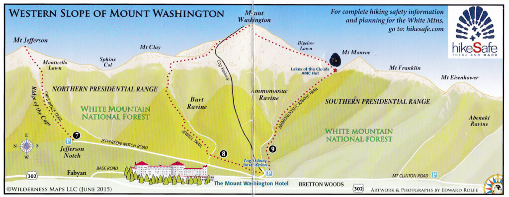
The four most commonly hiked routes are the Tuckerman Ravine and Lion Head Trails from the East, and the Ammonoosuc Ravine and Jewell Trails from the West.
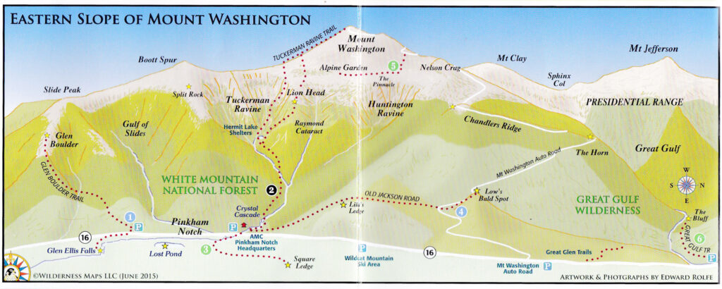
If you park at the AMC Pinkham Notch Visitor Center (no fee for parking, and there are bathrooms!) you can hike from the East side of Mount Washington. Tuckerman Ravine Trail (as an out-and-back to Mount Washington, 8.4 miles, 4,250’ of gain) is likely the most commonly hiked trail to Mount Washington, and for good reason – it has no significant scrambles, no water crossings without bridges, and has the least technical footing. That being said, you will be climbing up a (beautiful) waterfall and along some very narrow rock shelves with significant drop-offs. And speaking of waterfalls, you will pass Crystal Cascade just 0.3 miles from the trailhead! A lot of the rocky footing, particularly between the top of Tuckerman Ravine and the Mount Washington summit, is loose, so be sure to check for stability as you step along. This hike takes you right through the Hermit Lake Shelter area (where there are also bathrooms!) and you can see the “Bowl,” which is popular with backcountry skiers in winter. The views are glorious, as you rise through Tuckerman Ravine, culminating with the expansive views from the top of the ravine itself.
The other popular East side trail is Lion Head. This trail peels off from Tucks after 2.3 miles (as an out-and-back to Mount Washington, Tuckerman Ravine Trail / Lion Head Trail / Tuckerman Ravine Trail is 8.6 miles, 4,250’ of gain). This route has some significant scrambles, and the trail goes past a rock formation that really does look like the head of a lion! The trail follows the north side of the Tuckerman Ravine, with fabulous views of the surrounding mountains, and down into the ravine. Just like the Tuckerman Ravine Trail, the Lion Head trail has loose and rocky footing. The Lion Head Trail rejoins the Tuckerman Ravine Trail for the final ascent to the summit. Just like Tucks, the water crossings on this route all have wooden bridges.
Once the Tuckerman Ravine Trail and the Lion Head Trail come back together, the rest of the hike is exposed rocks right to the Mount Washington Auto Road. Once there the trail turns left and you come to a tall staircase. Definitely take time to ogle the views on and at the top of this staircase, noting that some of the most interesting summit photos are with structures in the foreground (such as the stairs!).
If you want to hike from the East and don’t want to hike out-and-back, consider hiking up Lion Head and down Tuckerman Ravine Trail for a fantastic loop option.
If you park at the Ammonoosuc Ravine Trailhead (USFS $5 fee to park, and there are bathrooms) off Base Station Road, you can hike from the West side of Mount Washington. The most common plan is to hike up Ammonoosuc Ravine Trail to the AMC Lakes of the Clouds Hut / Crawford Path to the Mount Washington summit / then down Trinity Heights Connector / Gulfside Trail / Jewell Trail (9.6 miles, 4000’ of gain). There are two reasons for this common loop choice: The first is that hikers are often peak-bagging and want to “tag” Mount Monroe on their way to Mount Washington. The second is that the Ammonoosuc Ravine Trail (aka “Ammo”) is very steep, so the loop allows for a challenging ascent, and a gentler descent. There are two significant water crossings on Ammo, and you get to hike up a waterfall in between them.
Just like the East side of Mount Washington, the trails on the West side of Mount Washington have loose and rocky footing. Happily, there are no significant scrambles on this route, though Ammo is quite steep in many places. When you are above treeline on Ammo you will see the AMC Lakes of the Clouds Hut, which is a terrific stopping point (including bathrooms and water). There you might start to cross paths with AT thru-hikers, as the route from the Hut to Mount Washington (Crawford Path) is part of the Appalachian Trail. Crawford Path has more of that loose and rocky footing, and the route is well marked by large cairns. Once you leave the summit, the Trinity Heights Connector takes you out into fine views of the Northern Presidentials, and the Cog Railroad. The Gulfside Trail has particularly loose and rocky footing, as does the Jewell Trail above treeline. Once below treeline, the Jewell Trail is a wonderful forested break from the sun. There is much less rocky footing (and even dirt!), and two wooden bridges to save you from any water crossings.
The most gentle approach from the West side is out and back via Jewell / Gulfside / Trinity Heights Connector (10 miles, 4000’ of gain.) Out and back via Ammonoosuc Ravine Trail / Crawford Path (9.2 miles, 4000’ of gain) does include the steep descent back down Ammo.
There are a seemingly endless number of ways to hike Mount Washington, and the very best resource for your hike is a book called “The 4000-Footers of the White Mountains.” The chapter on Mount Washington has detailed descriptions of the hikes noted above, as well as lots of other options. You can purchase this book online at this link or by stopping by The Mountain Wanderer bookstore (57 Main Street, Lincoln, NH).

Fawn on the Boott Spur ladder, 2024.
I have personally hiked Mount Washington 11 times and have hiked every possible trail as part of a project called Hiking the White Mountain Guide. My favorite way to hike Mount Washington is via the Boott Spur Trail, which follows the southern edge of Tuckerman Ravine. It is a longer route but the views are really spectacular! It starts at the AMC Pinkham Notch Visitor Center, and I am happy to report that this route has no water crossings. There are no significant scrambles, but there is, however, a really awesome ladder! I have had terrific luck with sunrise hikes to Boott Spur and would highly recommend it. For descent, I really like the Nelson Crag Trail to the top (non-scary) part of the Huntington Ravine Trail, and then to the fabulous Alpine Garden Trail. The Alpine Garden Trail has rocky but stable footing, is relatively flat, and has flowers! That connects back to the Lions Head and the Tuckerman Ravine Trails for the final descent, and if you are interested in this long and gorgeous route, I would recommend checking out the details in the book mentioned above.
Speaking of that book, there are two amazing authors who are both hiking legends and are local – Steve Smith and Mike Dickerman. I asked them both about their favorite routes to Mount Washington, and for any funny stories they might be able to share.
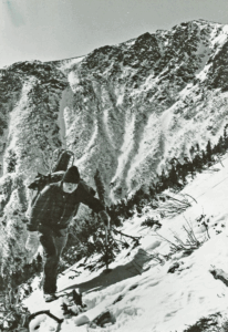
Steve Smith ascending the Lion Head Trail winter route with Mike Dickerman March 1988. Photo credit Mike Dickerman
Steve Smith is a co-author of the comprehensive “AMC White Mountain Guide”, “The 4000-Footers of the White Mountains” (alongside Mike Dickerman, below), and has penned many other hiking guide books. His bookstore in Lincoln, New Hampshire, The Mountain Wanderer, is a hub for all things hiking and the outdoors in the Northeast.
He shared that he has climbed Mount Washington 13 times, with the first ascent in 1974 with his friend Harry Cunningham. Steve says, “We were prototype “goofers.” I was wearing high-top leather work boots due to a fear of snakes. We plodded up Tuckerman Ravine Trail lugging forty-pound packs… Our four-hour uphill struggle left us exhausted at the summit building!” Steve also noted the Boott Spur Trail/Davis Path route as his favorite approach (I am in great company!). He says, “I love the varied views from the Boott Spur Ridge and the expansiveness of the Bigelow Lawn.” He is pictured to the right ascending Washington in winter via Lion Head on a 1988 excursion with Mike Dickerman.
Mike Dickerman founded the publishing arm Bondcliff Books in 1997, specializing in White Mountain hiking guides, books on local history, fishing guides, and more. He has authored or co-authored several books about the White Mountain region and is a longtime hiking enthusiast residing in Littleton, known as “the Main Street of the Mountains.”
Mike, pictured below with his brother, told me that he has climbed Mount Washington 7 times. His first ascent was in October 1982 via the West side trails. He didn’t own hiking boots, so borrowed them from his older brother. They were 2 sizes too big and wearing 2 pairs of heavy wool socks did not help much— He remembers the view into the Great Gulf on the descent, and that it eased some of the discomfort from his feet!
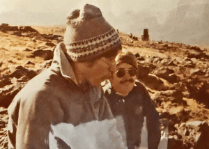
Mike Dickerman and his brother John Dickerman, Mount Washington summit, 1982. Photo courtesy Mike Dickerman
Ken MacGray is one of the editors of the “AMC White Mountain Guide” and the author of “New Hampshire’s 52 With A View – A Hiker’s Guide.” He is also editor of AMC’s “Southern New Hampshire Trail Guide,” and, like his aforementioned contemporaries, is a self-described hiking enthusiast that enjoys sharing knowledge with others.
When I asked him the same questions, he also said his favorite was the Boott Spur ascent! Ken said, “Super views most of the way, especially of Washington and down into Tuckerman Ravine.”
Ken MacGray at the Mount Washington summit in March 2017. Photo courtesy Ken MacGray
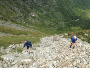
Denise Stassis (on the right) climbing the headwall on the Great Gulf Trail. Photo courtesy Denise Stassis
Denise Stassis is the first female to complete the NH Triple Crown – the Grid (hiking all 48 4,000-footers in every calendar month), Hiking the White Mountain Guide (hiking all of the trails in the White Mountain National Forest), and NH 500 highest (hiking all 500 of the highest summits in New Hampshire). She has actually now completed the Grid twice! When I asked her the same questions, she told me that she has hiked Mount Washington at least 25 times. She said, “my first ascent was in the early 1980s, when I was not a hiker. I did not own hiking boots or a backpack. I was fresh out of high school and got invited on a camping trip with some friends. The ascent was up Lion Head Trail… I had white sneakers, maybe tennis shoes, a bandanna wrapped around my head, shorts, a cotton tee, and a sweatshirt wrapped around my waist. I vividly remember the Alpine Garden and the beautiful flowers!” Denise says, “my favorite trail is the Great Gulf Trail!” The Great Gulf Trail is a very challenging scramble up a headwall, similar to the more well-known Huntington Ravine Trail.
No matter what route you choose to hike Mount Washington, be safe! As always, remember to check MWOBS’ Higher Summits Forecast prior setting out on your trek, and use the MWOBS text phone number (603-356-2137) to get current summit conditions and radar while hiking. All routes to Mount Washington have significant sun exposure, so definitely consider sunscreen, a hat, and UV blocking fabrics. Above treeline there are few natural water sources, but fortunately, during the warmer months, water can be found at the AMC Huts and at the Mount Washington State Park building. Have a terrific hike!
Fawn Langerman is a volunteer Steward for this year’s Seek the Peak event, a team partnering with the Observatory to help spread the word and share resources about MWOBS’ largest annual fundraiser. To learn more about the Stewards, visit seekthepeak.org/stewards, and to learn more about Seek the Peak, visit our FAQ page and consider joining us this year.

From Florida Heat to the Rockpile
From Florida Heat to the Rockpile By Alek Libby Hi everyone! My name is Alek Libby, and I am one of the summit interns here at Mount Washington Observatory this summer! I recently graduated
Summit Summer
Summit Summer By Aspen M. Hello everyone! My name is Aspen, I’m one of the summer weather interns here at the Mount Washington Observatory. I fell in love with weather at a young age
From the Sunshine State to the Home of the World’s Weather
From the Sunshine State to the Home of the World's Weather By Kristen Mihalcik Hello Everyone! My name is Kristen Mihalcik, and I’m one of the Summer interns here at Mount Washington. Enjoying
