
Say it ain’t snow!
2017-04-03 15:23:44.000 – Tom Padham, Weather Observer/Meteorologist
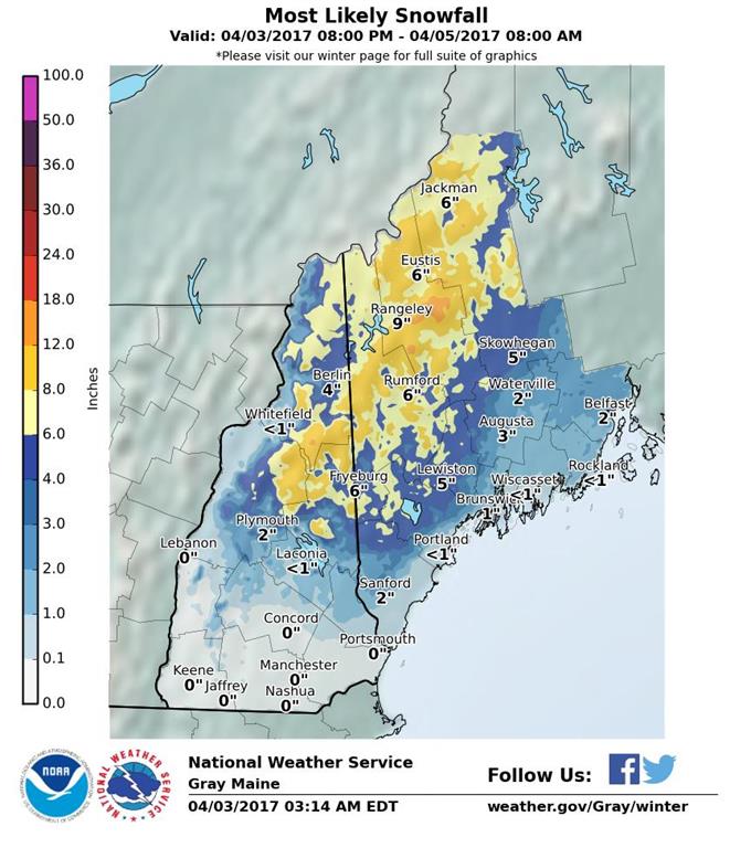
Confidence is growing that yet another significant winter storm (in April) will be taking place as early as tomorrow morning across the White Mountains. Low pressure spawning a severe thunderstorm outbreak over the Southeast today will track through the Great Lakes, with a secondary low pressure developing along the southern New England coast.
Warmer air and plentiful moisture will be pushing into New England tomorrow, with cold air damming occurring along the east side of the White Mountains. With enough deep cold air in place, it is now looking more likely that mostly snow will occur across the Mount Washington Valley and points northeast into interior Maine. This forecast is a very challenging one, especially for the summit, with warmer air attempting to surge in on the west side of the mountain while cold air hangs on to the east.
With the newer trends of enough cold air in place for mostly snow across the higher elevations, once again we’ll be seeing a very healthy amount of snow up here. 8-12” of new snow is possible across the summit and parts of western Maine, with some mixing with sleet and freezing rain possibly adding a bit of ice accumulation as well. If precipitation switches to more of a freezing rain/sleet mix then we’ll likely see much lower snowfall, potentially 4-8” of accumulation. Staff meteorologist Ryan is certainly going to have his hands full with the forecast tomorrow morning!
Precipitation will be tapering off to isolated snow showers by around noon Wednesday, with only a short break Thursday before another strong system begins to affect New England as early as Thursday evening. This storm looks to have an even stronger push of warm air, resulting in more of a rain and freezing rain event for the summit of Mount Washington. Although we’re now into April, winter isn’t over just yet atop the highest peak in the Northeast!
Tom Padham, Weather Observer/Meteorologist
Meet MWOBS’ 2026 Seek the Peak Teams
Meet MWOBS’ 2026 Seek the Peak Teams By MWOBS Staff Another year, another epic Seek the Peak! As of June 2026, there are 430 hikers signed up for Mount Washington Observatory's annual summer fundraiser and
What the Rockpile Taught Me (Besides How to Dress for the Arctic)
What the Rockpile Taught Me (Besides How to Dress for the Arctic) By Kathryn Hawkes It turns out that living on the top of a mountain will teach you A LOT of things. How
Hiker Safety
Hiker Safety By Fawn Langerman, Dave Fatula and Julie Saccardo USFS Trailhead Steward volunteering season has begun, and hiker safety is on my mind. Truthfully, hiker safety is always on my mind, but more
