
Temporary Snowpack Setback
2014-12-26 13:42:45.000 – Caleb Meute, Weather Observer / Education Specialist
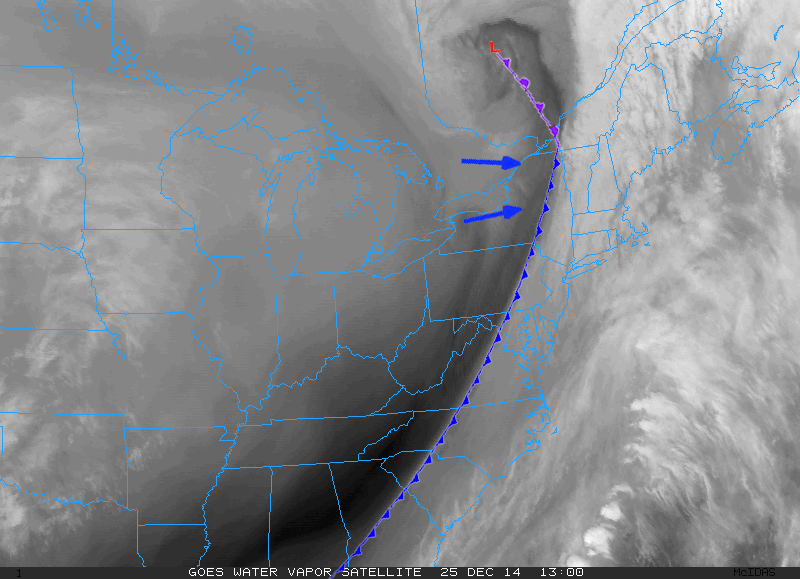
As you’re likely aware, a potent low pressure system brought record breaking warm air and copious amounts of rain into New England on Christmas Eve and into Christmas day – not exactly what snow lovers were hoping Santa would bring. A couple of factors came into play which led to the heavy rains and well above average temperatures. First off, at the 500 millibar level, a trough dug all the way down into the Gulf of Mexico which helped pump bountiful amounts of moisture up the eastern seaboard and into New England. If the center of low pressure had taken a track further east, New Hampshire may have seen precipitation in the form of snow, rather than rain. Unfortunately however; the low tracked through the Great Lakes region and into Southern Quebec. Because of this, all of New England was on the “warm sector” side of the storm, and with the deep digging trough, temperatures were able to soar to record levels.
Do not be too concerned snow enthusiasts, because cooler temperatures are beginning to filter into New Hampshire with the progression of the low northward. Temperatures will remain above seasonable through the weekend, but much cooler temperatures look to make a comeback next week.
Caleb Meute, Weather Observer / Education Specialist

Seek the Peak Spotlight: The Cloud Chasers
Seek the Peak Spotlight: The Cloud Chasers By MWOBS Staff Mike Bergeron and Desiree Bolton have been participating and volunteering for Seek the Peak for three years now. Together, they comprise Team Cloud Chasers

Celebrating 250 Years: The Declaration’s Legacy in the White Mountains
Celebrating 250 Years: The Declaration's Legacy in the White Mountains By Peter Crane We are now approaching July Fourth, Independence Day, the day when we celebrate the adoption of the Declaration of Independence in

Seek the Peak Spotlight: Ryan Shepard
Seek the Peak Spotlight: Ryan Shepard By MWOBS Staff Before Ryan Shepard moved to Conway, he was in Western New York celebrating his 40th birthday party. “I wanted to go big,” he said. “Big”
