
Wintry Weather to Come!
2014-12-08 17:59:03.000 – Michael Dorfman, Weather Observer/IT Specialist
The mountains of New Hampshire may see their biggest storm of the season so far with this next round of snow. With temperatures hovering just around the freezing mark, the amount of snow that falls will vary greatly depending on location. Southern and coastal areas will see warmer air, so they will see little or no snow out of this storm. A slushy 2-4 inches can be expected for Merrimack and Belknap counties, with more accumulation at higher elevations. Snow totals in Northern Carroll and Coos counties will be dramatically higher, with a widespread 10-14 inches falling by 7 PM Wednesday.
Once Wednesday passes, we won’t be completely out of the woods with precipitation. While precipitation should remain as (wet) snow throughout the entirety of this storm in the mountains, it may transition over to rain as warmer air pushes into the region. The bulk of the precipitation will fall by Wednesday morning, but with the low pressure system stalling out on top of us, we will see continued precipitation through Thursday.
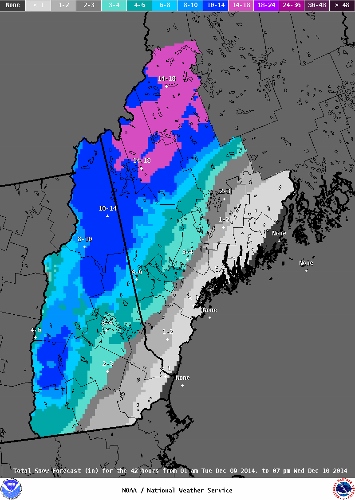 A product from the National Weather Service Gray, Maine office showing projected snowfall for the upcoming storm!
One extremely helpful resource when trying to determine snowfall is the National Weather Service’s Weather Prediction Center. One of their products is a probability map for specific snowfall depths across the US. The website for National Weather Service office in Gray, Maine is another great website and they have been putting out snowfall storm total maps here.
For all of you snow-lovers who are on the wrong side of the freezing mark for this storm, just take a look out west! The Coastal Range and mountains in the Northwest are about to get pounded with white concrete. Glancing at Mount Bakers’ point forecast for the next week, I see a low range of 112 inches and a high range of 135 inches of snow through Thursday night! 34-40 inches of snow are expected to fall overnight at Mount Baker! While these point forecasts are not always accurate for extreme locations like Mount Baker (or up here on Mount Washington), it will still undoubtedly receive extremely high snow totals in the coming days. It’s not surprising, since Mount Baker currently holds the world record for the highest seasonal snowfall of 1,140 inches! But don’t fear-winter is just starting here in the Northeast. There is so much more to come!
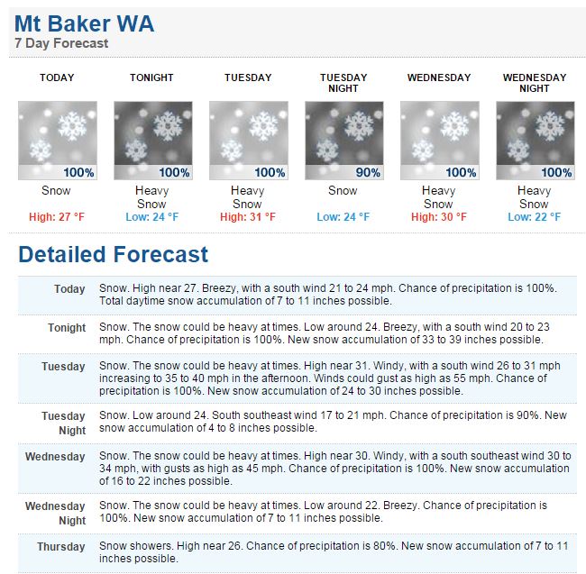 A screenshot from the NWS point forecast for Mount Baker
Michael Dorfman, Weather Observer/IT Specialist

Mountains and Meteorology: What More Could a Girl Need?
Mountains and Meteorology: What More Could a Girl Need? By Emily Grainger Hi everyone! My name is Emily Grainger, and I am one of this fall’s Summit Interns atop Mount Washington! I’m from Orlando,
My Fear of Weather Became a Love of Meteorology
My Fear of Weather Became a Love of Meteorology By Kaitlin Farrell Hello! My name is Kaitlin Farrell. I am one of the fall summit interns here at Mount Washington Observatory. I recently graduated
Ascending with High Winds
Ascending with High Winds By Alonso Lopez Hi! I am Alonso Lopez, one of four interns at Mount Washington Observatory from August to December, 2026. I was born and raised in the Dallas-Fort Worth