
Rain, Then Snow on the Summit
2014-11-24 16:53:46.000 – Michael Dorfman, Weather Observer/IT Specialist
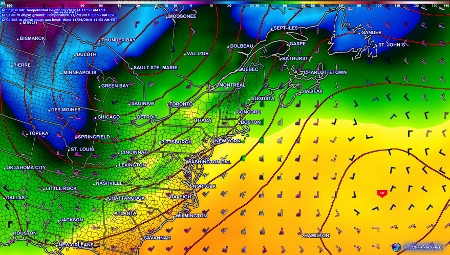
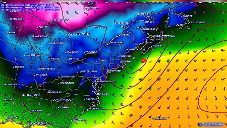
While rain pushes through the area today (see above), we’re all on the edge of our seats monitoring the forecast for Wednesday night and Thursday for what could be the first significant snowfall for the area! While the different weather models have not come into complete agreement, it looks like a coastal storm will be pushing into the region Wednesday and Thursday. At this point, it seems to be hugging the coast, with less of an effect further inland, but models can change dramatically in 48 hours, so keep your eyes peeled for updates!
Why is this storm rain and not snow? The simple answer is because it is too warm. But what dictates temperature in storms? One big principle in meteorology is that the characteristics of an air mass depend on where that air mass comes from. Low-pressure systems consist of a large area of atmosphere rotating counter-clockwise. In a perfect world, if you’re to the west (left) of the storm, the air mass you encounter will be coming from the north, and will generally be colder than typical air from your latitude. This is known as the “cold sector” of a storm. On the other hand, if the center of the storm is to your west, an air mass from the south is pushing toward you, allowing you to feel warmer temperatures, and increasing the chance of rain during winter storms. Of course, the atmosphere is never perfect, so variables involving atmospheric conditions, geography and water temperatures all play a role in how this general concept applies to specific situations.
We are currently being pummeled by rain from a low-pressure system. With southerly winds, our air mass is very warm, hence why we aren’t receiving snow from this storm (even on the summit of Mount Washington!) To the frustration of ski-minded individuals, the air mass that is pushing into the area gained a large amount of ocean moisture, allowing it to drop a significant amount of rain on the summit.
Michael Dorfman, Weather Observer/IT Specialist
The Precip Can: Measuring Rain, Snow, and Everything Else on Mount Washington
The Precip Can: Measuring Rain, Snow, and Everything Else on Mount Washington By MWOBS Staff Averaging 281 inches of snow per year, the Observatory is no stranger to measuring precipitation. While it might be
Meet MWOBS’ 2026 Seek the Peak Teams
Meet MWOBS’ 2026 Seek the Peak Teams By MWOBS Staff Another year, another epic Seek the Peak! As of June 2026, there are 430 hikers signed up for Mount Washington Observatory's annual summer fundraiser and
What the Rockpile Taught Me (Besides How to Dress for the Arctic)
What the Rockpile Taught Me (Besides How to Dress for the Arctic) By Kathryn Hawkes It turns out that living on the top of a mountain will teach you A LOT of things. How
