
Winter visits the summit
2014-10-20 18:09:00.000 – Tom Padham, Weather Observer/Meteorologist
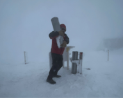
Winter has made a brief return to the higher summits, with temperatures bottoming out in the lower teens last night and the summit receiving some light snow accumulation along with over a foot of rime ice. Winds were also more typical of the winter season, with a peak gust of 80 mph, which made de-icing last night even more exciting. This morning we were treated to fantastic views as the higher summits cleared out of the fog, with a stark difference in color from the white summits of the Presidentials to the hues of fall in the surrounding valleys.
Unfortunately, this wintry scene across the summit will likely be short lived as a very slow moving Nor’easter brings heavy rain to New England. Temperatures will likely climb just above freezing for the majority of the event as warmer air surges in off the ocean. Tomorrow night into Wednesday morning could be interesting, as some of the models have the summit sitting just below freezing instead of just above. If this becomes the case, then heavy rain would likely be heavy freezing rain and sleet, with a significant ice storm for the summit of Mount Washington. Keep an eye on our higher summits forecast and current conditions page to see how this plays out!
Tom Padham, Weather Observer/Meteorologist
The Precip Can: Measuring Rain, Snow, and Everything Else on Mount Washington
The Precip Can: Measuring Rain, Snow, and Everything Else on Mount Washington By MWOBS Staff Averaging 281 inches of snow per year, the Observatory is no stranger to measuring precipitation. While it might be
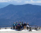
Meet MWOBS’ 2026 Seek the Peak Teams
Meet MWOBS’ 2026 Seek the Peak Teams By MWOBS Staff Another year, another epic Seek the Peak! As of June 2026, there are 430 hikers signed up for Mount Washington Observatory's annual summer fundraiser and
What the Rockpile Taught Me (Besides How to Dress for the Arctic)
What the Rockpile Taught Me (Besides How to Dress for the Arctic) By Kathryn Hawkes It turns out that living on the top of a mountain will teach you A LOT of things. How
