
A Chill In The Air
2014-01-23 21:35:14.000 – Mike Carmon, Weather Observer/Education Specialist

NULL
The bitter cold of winter has its grip on us, and doesn’t look to let go anytime soon! We’ve hit a low temperature of -24F three times this month already, and there looks to be colder times to come on the summit.
Our shift isn’t expecting to get above zero degrees nearly at all through next Wednesday (with the only possible exception to this coming on Saturday, where we have a chance of hitting a high temperature of +3F). Otherwise, we’ll be well into the negative numbers, with the most frigid conditions setting up for Sunday.
On Sunday, we could be pushing -25F once again, with very strong winds gusting in excess of 100 mph. A potential snow storm could follow that up on Monday, followed by another big dip in temperatures on Tuesday.
If you plan on coming to the summit, or anywhere else in the Whites for that matter, the name of the game for the next week will be ‘bundle up’!
Mike Carmon, Weather Observer/Education Specialist

From Florida Heat to the Rockpile
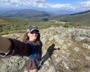
From Florida Heat to the Rockpile By Alek Libby Hi everyone! My name is Alek Libby, and I am one of the summit interns here at Mount Washington Observatory this summer! I recently graduated
Summit Summer
Summit Summer By Aspen M. Hello everyone! My name is Aspen, I’m one of the summer weather interns here at the Mount Washington Observatory. I fell in love with weather at a young age
From the Sunshine State to the Home of the World’s Weather
From the Sunshine State to the Home of the World's Weather By Kristen Mihalcik Hello Everyone! My name is Kristen Mihalcik, and I’m one of the Summer interns here at Mount Washington. Enjoying
