
Weekly Weather Summary March 18-24
2012-03-25 13:46:36.000 – Rick Giard, Weather Observer / Education Specialist
Weather Mar. 18-24
WEEKLY WEATHER SUMMARY
March 18-24, 2012
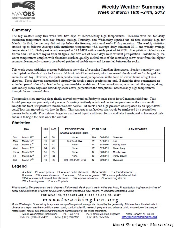
The big weather story this week was five days of record-setting high temperatures. Records were set for daily maximum temperature each day Sunday through Thursday, and Wednesday equaled the all-time monthly high for March. In fact, the mercury did not dip below the freezing point until early Friday morning. The weekly statistics stacked up as follows: Average daily maximum temperature 46.6, average daily minimum 35.1, and weekly average temperature 41.0. Daily peak winds averaged at 58.1 MPH with a weekly peak of 96 MPH. Precipitation totaled a trace frozen and 0.06 inches liquid from all types, and five out of seven days were without precipitation. Additionally, the warm temperatures coupled with abundant sunshine quickly melted most of the remaining snow cover from the higher summits, leaving only sparsely distributed patches of visible snow and ice nestled between the rocks.
This week began with high pressure building in the wake of a passing Canadian disturbance. Sunday tranquility was interrupted on Monday by a back-door cold front out of the northeast, which increased clouds and briefly plunged the summits into fog. However, this system produced minimal precipitation, in the form of several hours of light rain showers. These showers accumulated virtually the week’s entire precipitation total. Behind the front commenced an extended period of mostly clear but hazy, summer-like conditions. Advection of warm, moist air into the region, along with mostly sunny days and dwindling snow cover, perpetuated the exceptional, unseasonably high temperatures through the next several days.
The massive, slow-moving ridge finally moved eastward on Friday to make room for a Canadian cold front. This frontal passage was primarily a dry one, with gusting northerly winds and cooler temperatures as the main result. Despite the front, temperatures remained above normal. At week’s end high pressure was replaced by an upper-level cutoff low that moved slowly into the East. This spawned a surface low that would be reinforced by a second low passing to the north. Precipitation began as a mixture of liquid and frozen forms, and later transitioned to freezing drizzle and rain to begin the new week on the wet side.
Rick Giard, Weather Observer / Education Specialist

From One Mountain to the Next
From One Mountain to the Next By Ellie Derry Hi everyone! My name is Ellie Derry and I am one of the fall 2026 interns at the Observatory. I’m super excited to be here

Mountains and Meteorology: What More Could a Girl Need?
Mountains and Meteorology: What More Could a Girl Need? By Emily Grainger Hi everyone! My name is Emily Grainger, and I am one of this fall’s Summit Interns atop Mount Washington! I’m from Orlando,

My Fear of Weather Became a Love of Meteorology
My Fear of Weather Became a Love of Meteorology By Kaitlin Farrell Hello! My name is Kaitlin Farrell. I am one of the fall summit interns here at Mount Washington Observatory. I recently graduated