
Irene again
2011-08-28 19:26:11.000 – Mike Carmon, Weather Observer/Meteorologist

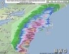
NE totals as of 6:30 p.m. 8/28
She came, she saw, she drenched.
I’m referring to Irene, of course…a storm with fury that rolled through most of the eastern U.S., dropping tremendous rainfall amounts and creating widespread wind damage all across these areas.
There are so many reports of damage and flooding, it’s hard to know where to start. North Carolina’s Outer Banks receieved the worst the storm could dish out, as expected, with yet another new shape to the coastline chiseled out. Irene came ashore at Cape Lookout, and charged northward, with sustained winds of 90 mph and gusts reaching 120 mph. Holly Shelter, just to the northeast of Wilmington, NC, which sits west of where Irene came ashore, recorded 8.26″ of rain as of 2PM Saturday.
Irene then passed directly over Corolla, NC on the northern banks, making a very close pass to the Virginia Beach/Norfolk area as it moved offshore once again. The storm picked up speed and paralled Virginia and Maryland’s eastern shores, before making a second landfall as a Category 1 Hurricane at Atlantic City, NJ. Gusts to 60 and 70 mph were felt all across New Jersey, and flooding all across Delaware and New Jersey is immense. Some of the highest preliminary rainfall totals are 11.48″ in Tuxedo Park, NY, 11.34″ in Easton, MD, 10.43″ in Ellendale, DE, and 10.32″ in Stockton, NJ. After reading these astronomical numbers, and seeing plenty of pictures of extreme flooding, I was elated to learn that all of my close family, relatives, and friends who live in central New Jersey (my point of origin) are all safe.
Around 9 a.m., Irene came ashore at Coney Island, NY, with her center passing right over Brooklyn and the Bronx. A wind gust of 91 mph was recorded in Sayville, NY, which is located on the southern shore of Long Island. Central Park recorded a maximum wind gust of 60 mph.
It’s still too early to assess all of the impacts Irene has had on New England, primarily due to the fact that as of 5 p.m., Irene is still traversing the Connecticut River Valley. However, preliminary reports are conclusive that, even as a tropical storm, Irene had (is having) a significant effect across this area as well. Rainfall totals ranged from 4-8″ for most of New England, with the highest amounts reported across northwestern Connecticut and northwestern Massachusetts. Also, many of these reports do not include this afternoon’s precipitation, so we’ll have to wait until tomorrow for more complete data.
Up here on the summit, we reached a maximum wind speed of 104 mph multiple times this afternoon. We are currently in a lull as Irene’s center passes nearby. However, winds are expected to pick up to even higher speeds on the backside of the storm, so for now, we wait for the resumption of high winds, with temperatures nose diving from today’s high of just shy of 60 degrees down to tonight’s forecasted lows in the upper 30s. I’m still holding out hope for a century club attempt!
Mike Carmon, Weather Observer/Meteorologist

From Florida Heat to the Rockpile
From Florida Heat to the Rockpile By Alek Libby Hi everyone! My name is Alek Libby, and I am one of the summit interns here at Mount Washington Observatory this summer! I recently graduated

Summit Summer
Summit Summer By Aspen M. Hello everyone! My name is Aspen, I’m one of the summer weather interns here at the Mount Washington Observatory. I fell in love with weather at a young age

From the Sunshine State to the Home of the World’s Weather
From the Sunshine State to the Home of the World's Weather By Kristen Mihalcik Hello Everyone! My name is Kristen Mihalcik, and I’m one of the Summer interns here at Mount Washington. Enjoying
