
Changes in the snowpack…
2007-03-15 07:28:50.000 – Jim Salge, Observer

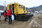
First sign of mud season at the base…
Less than a week after ending our 60+ day streak without hitting the freezing mark, we find ourselves in a 24 hour period without going below freezing. In fact, the high temperature of 43 degrees yesterday tied the record high for the date.
The mountain had a much different look yesterday as we ascended for shift change. Many bare spots, plenty of slush, some runoff, and the beginning of mud season down low, as evident from this picture. It’s all part of the highly changeable weather patterns that you expect around the beginning of spring. Though extreme temperatures swings are common all times of year on the mountain, late March and April tend to see those swings traverse the freezing mark, leading to dramatic changes in snow pack.
The freezing mark will again be traversed this morning as temperatures plummet behind this cold front. Rain will change to snow, before clearing skies this afternoon should give a dramatic sunset view on our new West View Camera. More snow is then likely tomorrow night, and cold air will rule out for the rest of the shift. I guess the guys on the other shift were on to something…
Jim Salge, Observer
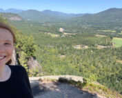
My Fear of Weather Became a Love of Meteorology
My Fear of Weather Became a Love of Meteorology By Kaitlin Farrell Hello! My name is Kaitlin Farrell. I am one of the fall summit interns here at Mount Washington Observatory. I recently graduated
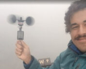
Ascending with High Winds
Ascending with High Winds By Alonso Lopez Hi! I am Alonso Lopez, one of four interns at Mount Washington Observatory from August to December, 2026. I was born and raised in the Dallas-Fort Worth

26th Annual Seek the Peak Recap
26th Annual Seek the Peak Recap By Drew Bush Members of the "Peak Potential" team gather at Pinkham Notch before hiking Mount Washington for the 26th Annual Seek the Peak. View more images. We’ve had