
State of the snow pack
2006-11-14 15:11:49.000 – Jim Salge, Observer

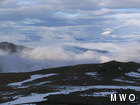
State of the snow pack…
Well, I’ve been up here a week now, and the temperature has only dropped below freezing twice. Winds and fog have dealt the snow pack quite a beating. Rain has fallen almost ever day, and snow pants have been traded in for summer shells. And the hope of the crew to use the snowcat throughout the remainder of the season has literally melted away. Record high temperatures have fallen from the history books, and average temperatures (now in the teens) mock us from the weather archives within. After the snowy October, this is not how I envisioned November.
Hope resides in the forecast, though at this point only the long range forecast. The pattern responsible for this warm air looks to finally break down again during the middle of next week, and thereafter, I hope we rapidly re-descend into winter’s icy grasp, this time for good!
The view in the attached picture shows the state of the summit snow pack in a brief break just moments ago. As you can see, winter’s return can’t come quickly enough!
Jim Salge, Observer

Seek the Peak Spotlight: The Cloud Chasers
Seek the Peak Spotlight: The Cloud Chasers By MWOBS Staff Mike Bergeron and Desiree Bolton have been participating and volunteering for Seek the Peak for three years now. Together, they comprise Team Cloud Chasers

Celebrating 250 Years: The Declaration’s Legacy in the White Mountains
Celebrating 250 Years: The Declaration's Legacy in the White Mountains By Peter Crane We are now approaching July Fourth, Independence Day, the day when we celebrate the adoption of the Declaration of Independence in

Seek the Peak Spotlight: Ryan Shepard
Seek the Peak Spotlight: Ryan Shepard By MWOBS Staff Before Ryan Shepard moved to Conway, he was in Western New York celebrating his 40th birthday party. “I wanted to go big,” he said. “Big”
