A Cooler and Wetter July 2021
2021-08-09 16:52:13.000 – Brian Fitzgerald, Director of Science and Education
July 2021 was much wetter and cooler than normal, particularly down in North Conway where the Mount Washington Observatory operates the“NCON3” Cooperative Weather Station (more information about the station and its history
can be found here). Up on the summit of Mount Washington, weather observers recorded similar conditions throughout July, but with some both obvious, and not-so-obvious differences.
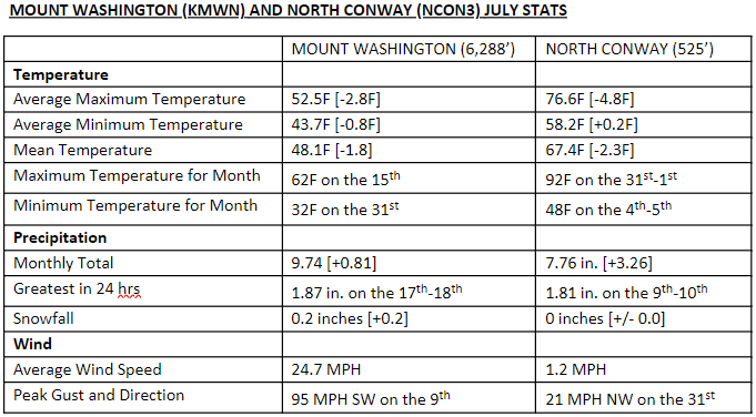
Figure 1: July temperature, precipitation, and, and wind statistics at Mount Washington (KMWN) and North Conway (NCON3).
Down in North Conway, daily maximum temperatures struggled to warm past 80F for more than half of the month. While daily maximum temperatures averaged nearly five degrees cooler than normal, daily minimum temperatures managed to average 0.2 degrees F warmer than normal. July 2021 overall averaged a daily mean temperature of 67.4, which was more than two degrees F cooler than normal, and the first cooler than normal month since February of this year. Prior to that, our last cooler than normal month was March of 2020.
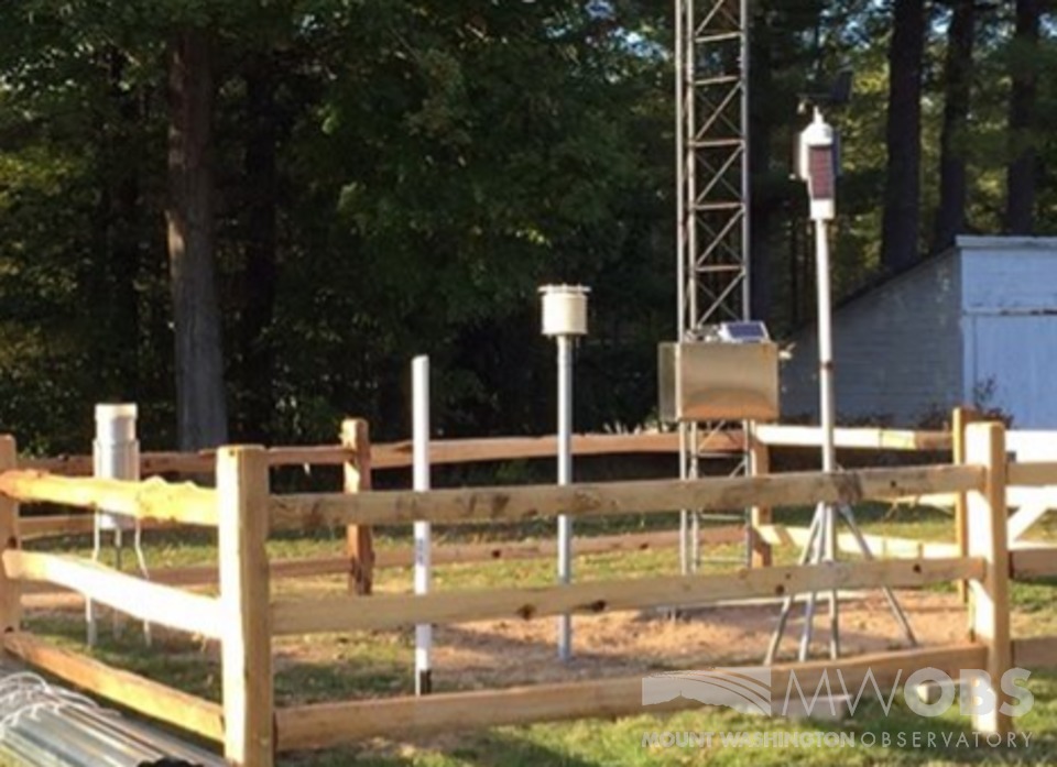
Figure 2: North Conway, NH COOP Weather Station, station identifier – NCON3.
For the summit of Mount Washington, daily maximum temperatures averaged quite a bit cooler than normal as well, at almost 3 degrees F below normal. Minimum temperatures on the summit averaged cooler than normal as well, combining with daily maximum temperatures for the month that created a mean of 48.1F. Both the summit and valley were nearly 2 degrees F cooler than normal for the month, but in different ways, perhaps reflecting how the two locations experience diurnal heating and cooling differently. When compared with the valley, the summit station’s last cooler-than-normal month was just this past May.
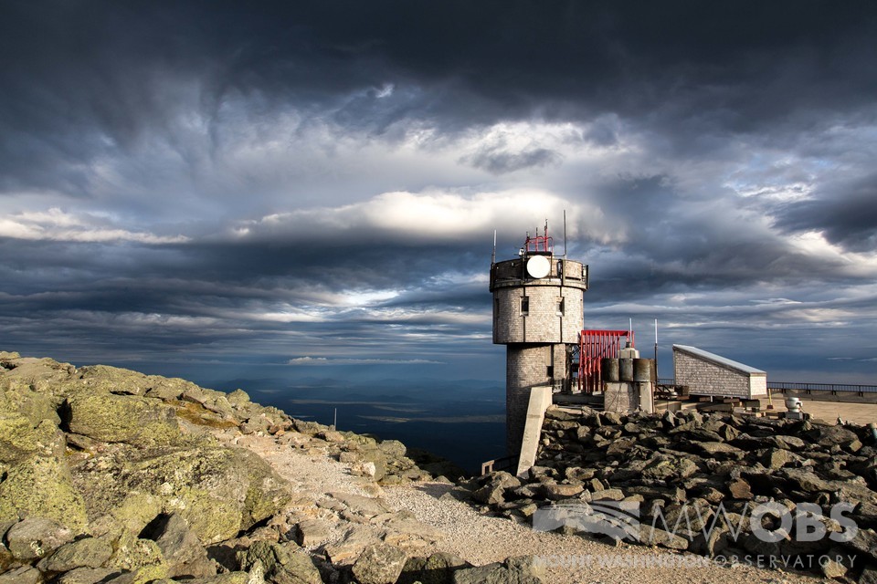
Figure 3: The Mount Washington Observatory’s summit weather station and instrument tower, station identifier – KMWN.
All but six days had measurable precipitation throughout the month of July 2021on both the summit and down in the valley in North Conway. An active pattern contributed to disturbance after disturbance passing through the region, with tropical storm Elsa moving through southern New England on the 9th/10th, producing the highest rainfall total in 24 hours at 1.81 inches in North Conway. Rainfall was not quite as heavy from that event on the summit, which saw an even greater precipitation event over 24 hours on the 17th/18that 1.87 inches. Overall, precipitation totaled 7.76 inches for the month in North Conway, coming in at 3.26 inches above normal. Observers on the summit recorded more precipitation at 9.74 inches; however, the departure from normal was less at 0.81 inches wetter than normal. Areas to our south, including Concord, NH, saw nearly double the amount of rainfall through the month, setting new records for the wettest July.
Though rainfall was significant for the month, the US Drought Monitor is reporting that northern Carroll and Southern Coos Counties experiencing “abnormally dry conditions”, due to many consecutive months of less than normal precipitation. Precipitation for the year to end of July totals 21.52 inches, which is 6.05 inches drier than normal for North Conway, while the summit has received 36.15inches, which is 17.37 inches below normal through July.
—-
If you’re interested in learning more about how “normal” is calculated for these sites and beyond, I’d highly recommend you register for our upcoming talk on Tuesday, August 10that 7 pm when New Hampshire State Climatologist and UNH Associate Professor Mary Stampone, and MWO Staff and Interns present about the newly released 1991-2020 climate normals. For more information about how to register, or view recorded Science in the Mountains programs, follow the link
here.
Brian Fitzgerald, Director of Science and Education


