A Crash Course in Cyclogenesis and Conveyor Belt Theory
2018-07-02 18:18:05.000 – Sarah Thunberg, Summit Intern
Standing at the base of the mountain Wednesday morning, I was jumping with energy and excitement to get back on the summit this week. It doesn’t take much to get me excited in the first place, but this week was looking promising for storms. The storm that passed Thursday and Friday followed the classic mid-latitude cyclone lifecycle. This particular cyclone was already weakening as it hit New England so we only received a lot of rain and small cells scattered across New Hampshire. Later in the week we got some much nicer thunderstorms that were beautiful to watch as a meteorologist. Friday afternoon I was watching thunderstorms pop up all around me while I was doing little happy dances in my chair. After a weaker thunderstorm cleared the summit, I went outside to take a look at the large cell I had been watching on the radar just southwest of Mount Washington. Of course as I was admiring the storm to our west, I heard people talking about a rainbow to the east. It was gone by the time I turned around.

While all the storms were popping up Friday, I was asked a lot of questions about thunderstorms and ‘bad’ weather up here. So without further ado, here is my attempt at explaining some of this.
Most storms people think of are actually mid-latitude cyclones, and they generally produce lines of thunderstorm cells, or widespread rain. A mid-latitude cyclone is really just an area of low pressure that forms east of a dip in the jet stream in the Northern Hemisphere. We call these dips troughs because they generally are where large cold masses of air can be found. The jet stream weaves in between these pools of cold air and warm air. The air in the jet stream behaves a lot like cars on a highway, just before a tight turn the cars (air) pile up and create a traffic jam. Coming out of the turn, cars speed back up again and there’s a lot of space between cars. Thinking of air behaving like this, when the air piles up (converges) before a trough it creates high pressure before the trough, and low pressure after the trough where it spreads out (diverges).

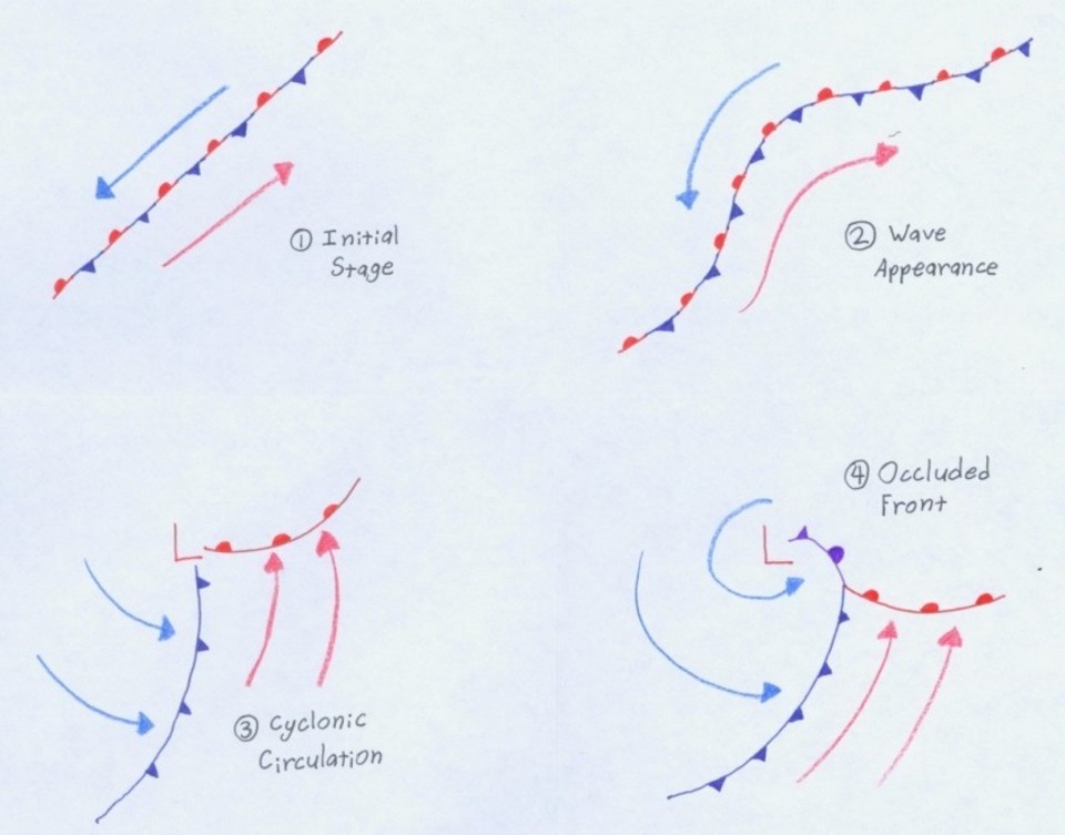
The area of low pressure east of the trough starts out as a slight drop in pressure along a temperature gradient between the cold air and warm air. The warm and cold air behave like two separate masses of air, one of them is cold and dry, the other is warm and moist, and they don’t mix together. The low sitting in between the two air masses makes the wind turn slightly towards the low, and eventually the wind is making a full counter-clockwise circle around the low. This makes the warm and cold air masses start rotating around the low creating the warm and cold fronts. The type of the front is determined by which air mass is pushing the front forward. The cold front has the cold air mass blowing into the warm air mass and the warm front has the warm air mass blowing into the cold air mass. The warm air will rise up and over the cold air with both fronts because warm air has a lower density and cold air. At the surface this means the cold air gets wrapped completely around the low. When the cold air catches up to its back side the front turns into an occluded front because the cold air is blowing into itself. This is what eventually kills the cyclone because it needs that temperature gradient to sustain itself. I drew out the whole cyclone lifecycle below for reference.
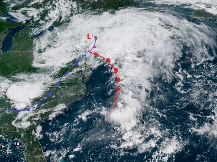
The picture above shows the cyclone from the NOAA satellite GOES-16 on Thursday as it was entering New England. I’ve drawn the fronts on the image, but the cyclone was getting more disorganized at this time so it’s hard to picture the structure. Looking at the cyclone a day earlier shows a much more defined structure. The image below shows the cyclone from the same satellite Thursday through the moisture of the air; yellow indicates dry air and blue/white/green indicates moist air with green being the wettest.

The warm air blows north around the west side of the low and rises up and over the cold air at the warm front following the path shown by the red arrows. The cold air follows the black arrows and moves west on the north side of the low and wraps around to the western side of the low forcing the warm air up and over it along the cold front. The circulation of these air masses actually pulls in dry air from higher in the atmosphere just behind the cold front, contributing to the clearing and drying behind the cold front. The flow pattern of these air masses is drawn out in the diagram below.
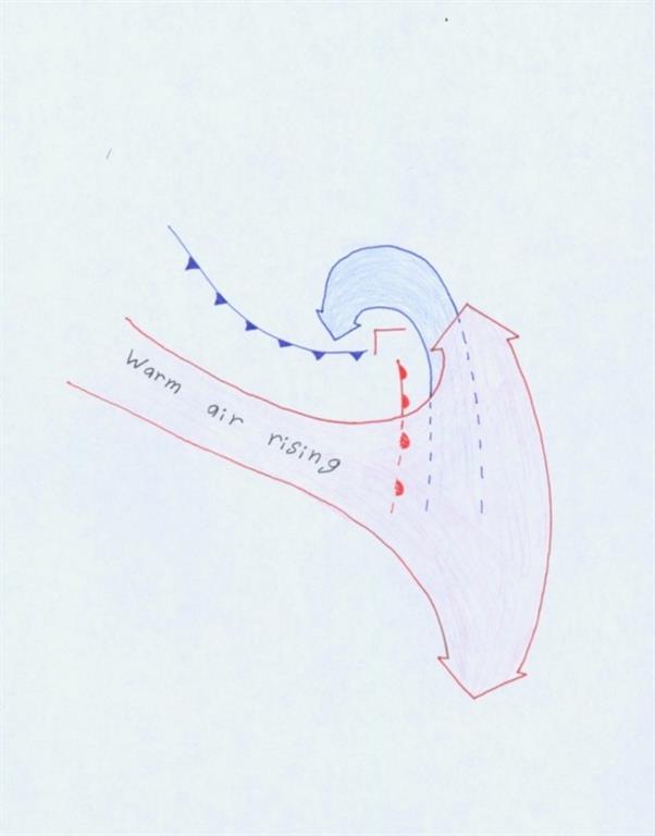
The drying of the cold air and the fact that the cold air wraps around itself are the main processes that limit the strength and lifetime of the cyclone.
Sarah Thunberg, Summit Intern
Three and a Half Months of Snow, Ice and Rime
Three and a Half Months of Snow, Ice and Rime, with Deeper Drifts. By Ryan Steinke Me outside on the summit near the Yankee Building. My internship with the Mount Washington Observatory
Supporter Spotlight: Righteous Vices Coffee Roasters
Supporter Spotlight: Righteous Vices Coffee Roasters By MWOBS Staff Righteous Vices Coffee Roasters, a local coffee roaster and shop located in Center Conway, New Hampshire, has been a partner of the Observatory since 2024.
Winter Storm Tracks Across New Hampshire
Winter Storm Tracks Across New Hampshire By Alex Branton As winter comes to a close, most of us are ready for the warmer temperatures and sunshine that come with Spring and Summer. Although we

