
A look back, a look ahead…
2007-01-18 21:08:29.000 – Brent Antkowiak, Summit Intern

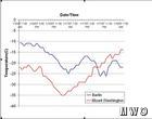
48 hour temperature comparison
With the recent shot of cold air delivering frigid temperatures and hurricane force winds, the summit crew has been very busy with keeping tabs on what’s going on outside, both on the summit and across the region. An interesting scenario that I was asked to look at has been how the temperature has varied between the summit and nearby Berlin, a valley location, the past few days. Please reference the chart at right while reading the comment. It is a graph of the temperatures during the past 48 hours, through earlier this morning.
After the cold front ripped through the area Tuesday afternoon, it was intriguing to see the temperatures drop and drop Tuesday night until bottoming out at around -35 C at the summit. At the time, the high pressure ridge dominating the air mass near the peak early Wednesday morning as our temps bottomed out. Berlin’s daily low followed shortly and they hit their minimum a few hours after us, in a typical diurnal fashion (warming during the day, cooling during the night), at about -25 C.
As Wednesday progressed, both locations increased temperatures proportionally during the daylight hours. What happened next is a common occurrence in the White Mountain region. The summit kept its warming trend throughout the night while Berlin began to drop off in the early evening under clear skies. By 11pm Wednesday night, Berlin was over 10 C COLDER than the summit! From the chart, you can see that the summit had warmed to the low-mid teens below 0 C by morning, while Berlin stayed in the lower 20’s below 0 C throughout the entire night.
Now as for why this happened, there are a few factors that are contributing to the situation. For temperatures to bottom out in the valley in a cold air mass, all factors that support radiational cooling must be in place. These factors, which combine for rapid overnight cooling of the lower atmosphere are a recent snow cover, clear skies, and light winds. The first day after a cold front is typically too windy in Berlin for real radiation to take place, and Berlin sees its coldest temperatures on day two of an air mass after the high has moved overhead, and the winds die off. However, the higher elevation of the summit does not typically follow such a diurnal cycle, and is influenced much more by the air masses themselves. Cold air initially rushes in, but as the high crests giving the valley their coldest night, the summits are warming both by a cut off of the cold air moving in, as well as compression warming under the high pressure area. Thus you can see that while the valleys were coldest, the summits had already warmed 30 degrees F.
That’s an explanation of what has happened on the summits…for a brief look ahead…
On the summit, we are looking forward to the potential for strong winds Saturday night. VERY strong winds to be more emphatic. Current projections are estimating over 100 mph sustained with gusts to who knows! 120? 130? 160? There is the potential for the summit to experience winds it has not seen in several years. Of course, with the sad, sad winter we have had thus far, the forecast models are probably just teasing us again, as they have become so good at over the past few months!
Brent Antkowiak, Summit Intern

Team Flags Return for Seek the Peak’s 25th Anniversary
Team Flags Return for Seek the Peak's 25th Anniversary By MWOBS Staff Mount Washington Observatory is looking forward to continuing a much-loved tradition for Seek the Peak’s 25th Anniversary: Team flags. In inviting teams
Meet Summer Interns Zakiya, Max and Maddie
Meet Summer Interns Zakiya, Max and Maddie By MWOBS Staff We are excited to welcome six teammates to the summit of Mount Washington this summer! During their internship, these students and graduates will play

Saying Goodbye to the Summit
Saying Goodbye to the Summit By Alexis George After an extraordinary last three years working as a Weather Observer and Meteorologist, I am excited to pursue a different career. As sad I as am
