
A look through the fog at the fog
2011-09-21 18:22:18.000 – Mike Carmon, Weather Observer/Meteorologist
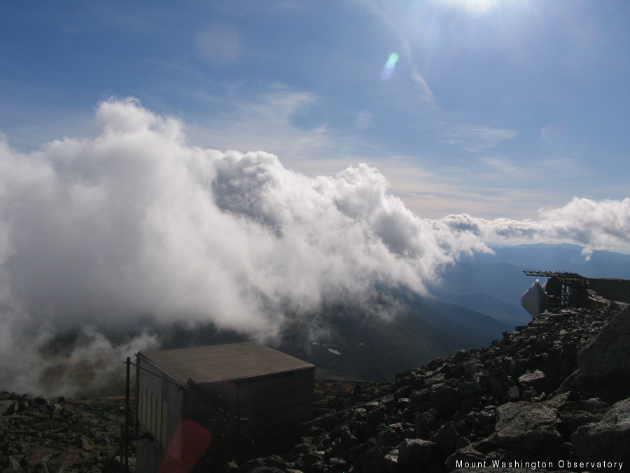
A Cool View
A discussion in our weekly staff meeting earlier today, along with a drive this morning to the base of the mountain through thick and soupy fog in the valleys of central and eastern Vermont, have prompted my thoughts to follow: What, exactly, is fog?
For a basic definition, the average person in the era we find ourselves in would turn to Wikipedia. What would you find? The description is quite lengthy, but the basic definition according to Wikipedia is ‘a collection of water droplets or ice crystals suspended in the air at or near Earth’s surface.’ This definition is sufficient for the average individual, but if you’d like to know more, then read on…
A more reliable resource for this kind of information would be the National Aeronautics and Atmospheric Administration (NOAA), which defines fog as ‘water droplets suspended in the air at the Earth’s surface.’ A similar definition indeed.
The Federal Meteorological Handbook-1 (FMH-1), which prescribes the code by which weather observations are taken, has a much more in-depth definition stating that fog is ‘a visible aggregate of minute water particles (droplets) which are based at Earth’s surface and reduces horizontal visibility to less than 5/8 statute mile and, unlike drizzle, it does not fall to the ground.’ This statement puts discrete numbers to the description, and better states the overlying difference between fog and very low clouds–based at Earth’s surface.
Fog is not just a cloud at or near the ground, but the water droplets are based there, meaning they were formed due to some interaction between the surface of the Earth and the air directly above it. For instance, warm air flowing over a colder surface that consequently cools to the dew point and allows water vapor to condense while suspended in the air (radiation fog) is one such example.
A common type of fog seen on Mt. Washington is upslope fog, which develops because moist air cools as it is forced upwards over a mountain, and eventually reaches its dew point, allowing the water vapor to condense out to form minute droplets. The main point here is that, if the mountain were not there, the fog (cloud) would not form, so the interaction with the surface of the earth is in fact what prompted the development of the cloud. If this cloud is touching the ground, it is thenceforth classified as fog.
The FMH-1 also goes on to differentiate between fog and mist, which are formed by the same processes, except mist is defined as reducing horizontal visibility to 5/8 or greater but less than 7 statute miles. Fog is reported with the symbol FG in a weather observation, while mist is given the abbreviation BR.
So if you step out the door tomorrow morning, and are greeted with a shield of fine water droplets hanging in the air, but you can see 1 mile down the road, you now know you are technically looking into a mist, and not a fog. But be careful–if the drops are falling, it is most likely drizzle! But that’s a weather lesson for another comment.
Mike Carmon, Weather Observer/Meteorologist

Supporter Spotlight: Righteous Vices Coffee Roasters
Supporter Spotlight: Righteous Vices Coffee Roasters By MWOBS Staff Righteous Vices Coffee Roasters, a local coffee roaster and shop located in Center Conway, New Hampshire, has been a partner of the Observatory since 2024.
Winter Storm Tracks Across New Hampshire
Winter Storm Tracks Across New Hampshire By Alex Branton As winter comes to a close, most of us are ready for the warmer temperatures and sunshine that come with Spring and Summer. Although we

Bringing Polar Byrd I to Mount Washington
Bringing Polar Byrd I to Mount Washington By Jackie Broccolo In 1968, my grandfather joined the Polar Byrd I “Dustin Transpolar Flight”, which was the first commercial flight to carry civilians across both poles
