A shared sunrise.
2007-08-05 05:25:12.000 – Ryan Knapp, Meteorologist
Sunrise, a shared experience.
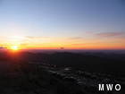
Sunrise, it’s a time of solitude, tranquility, and awe most mornings. But this morning, I got to share the experience with those fortunate enough to drive up the auto road in time. Sunrise was at 0530 EDT (0430 EST or as we like to call it, obs time) and it could not have been better. Visibility was a bit over 120 miles in every direction with just a few clouds in the sky to provide some color. The only dust on this gem of a sunrise was the temperature of 37F and a wind chill of 23F. But those who were eager enough arrived in droves bundled in hoodies, coats, and blankets to see the highest sunrise in the northeast. To give you an idea of what they saw, let me show you what I captured.
Picture 1 – a view from the parapet.
Picture 2 – seconds before the sun came up.
Picture 3 – a view from “under” the building.
Picture 4 – reflections of a sunrise.
Picture 5 – a golden view.
The last two days were very picturesque as well, but not for sunrises, more for the cumulonimbus clouds that formed around the summits. Now for a science lesson: A cumulonimbus clouds (or CB as weather observers call them) are a genus of dense clouds with a low base that extends vertically to a great height, sometimes reaching all the way to the tropopause. It forms in towering shapes and usually has a smooth, flattened top marking the level beyond which air is unable to rise by convection. These types of clouds usually carry heavy precipitation and are associated with thunderstorms. This was most certainly true the past few days.
The first one that was clearly seen was on Friday afternoon when a thunderstorm passed just north of the station and the fog opened up briefly. These thunderstorms continued into the night with additional viewing windows in the fog. The lightning was flashing like the bulbs on the cameras of the paparazzi. I felt like such a celebrity. As Brian mentioned yesterday, I tried to take a picture of them but had no success, so sorry.
The second one that was seen was yesterday over Maine about 50 to 60 miles to our east. It was well defined and with great visibility, the CB in its entirety was captured. Being daytime and so far away, we could not make out any lightning, but the Doppler radar we use was showing plenty of strikes. Beautiful from a distance but dangerous to those stuck under them. But all in all, the past three days have been busy in their own right but we found time to enjoy what we saw. Who else can say that about their jobs?
Ryan Knapp, Meteorologist
Team Flags Return for Seek the Peak’s 25th Anniversary
Team Flags Return for Seek the Peak's 25th Anniversary By MWOBS Staff Mount Washington Observatory is looking forward to continuing a much-loved tradition for Seek the Peak’s 25th Anniversary: Team flags. In inviting teams
Meet Summer Interns Zakiya, Max and Maddie
Meet Summer Interns Zakiya, Max and Maddie By MWOBS Staff We are excited to welcome six teammates to the summit of Mount Washington this summer! During their internship, these students and graduates will play
Saying Goodbye to the Summit
Saying Goodbye to the Summit By Alexis George After an extraordinary last three years working as a Weather Observer and Meteorologist, I am excited to pursue a different career. As sad I as am


