
A Wee Bit of Snow
2006-12-30 09:24:43.000 – Mike Finnegan, Summit Intern

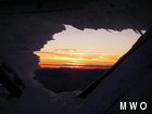
Sunset
High pressure yesterday brought us clear skies and phenomenal visibility, up to 120 miles. Whiteface in New York could be seen with the naked eye and my home mountain of Jay Peak appeared even more grand than normal due to an inversion just above the horizon. The afternoon brought a few high cirrus clouds, which gradually increased as the shadows grew longer. These made for a fine sunset, coloring up quite nicely. It seems the trend of increasing cloud cover has continued on through the night as the summit currently finds itself blanketed by a fog. These clouds will likely produce snow today, amounts ranging between two and four inches. It might not be much snow, but at least it’s something, and at this point in the season, I think we’ll take what we can get. Hoping winter reaches all of you soon…
Mike Finnegan, Summit Intern

Seek the Peak Spotlight: The Cloud Chasers
Seek the Peak Spotlight: The Cloud Chasers By MWOBS Staff Mike Bergeron and Desiree Bolton have been participating and volunteering for Seek the Peak for three years now. Together, they comprise Team Cloud Chasers

Celebrating 250 Years: The Declaration’s Legacy in the White Mountains
Celebrating 250 Years: The Declaration's Legacy in the White Mountains By Peter Crane We are now approaching July Fourth, Independence Day, the day when we celebrate the adoption of the Declaration of Independence in

Seek the Peak Spotlight: Ryan Shepard
Seek the Peak Spotlight: Ryan Shepard By MWOBS Staff Before Ryan Shepard moved to Conway, he was in Western New York celebrating his 40th birthday party. “I wanted to go big,” he said. “Big”
