
Arctic Freeze!!!
2013-11-23 17:58:47.000 – Pratik Patel, Summit Intern
cold air seeping over the Great Lakes
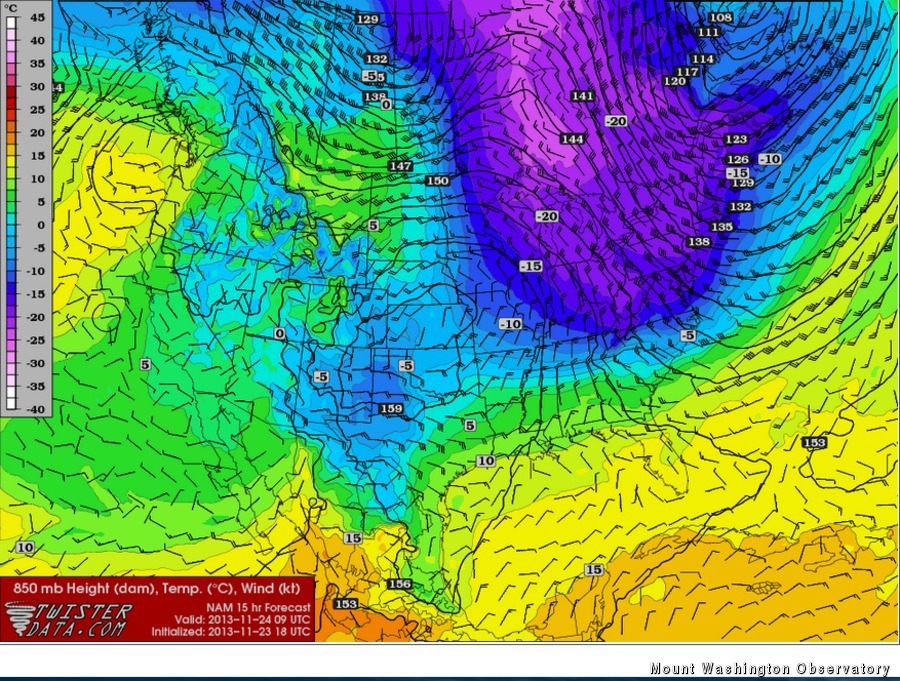
As you may know, winter has already started on top of Mt. Washington a few weeks ago. Over the next 36 hours, the polar jet stream will dip over the Midwest and the high and low pressure systems over central and northeastern North America will help funnel in cool Arctic air over the northeast. Here on the summit, we will see temperatures plummet to mid teens below zero! As the surface high builds up over the Midwest and pushes eastward, a relatively strong pressure gradient force (a strong pressure gradient force will have many pressure lines packed tightly together over a certain area) will develop in relation to the low over eastern Canada and north of Nova Scotia. Adding these hurricane force winds with the bitter cold Arctic air, wind chills will fall to nearly 50 below zero! As this system moves on and the building high over the Midwest continues to move east towards the Atlantic, weather conditions should quiet down and sunny skies are a good possibility mid next week.
Pratik Patel, Summit Intern

Seek the Peak Spotlight: The Cloud Chasers
Seek the Peak Spotlight: The Cloud Chasers By MWOBS Staff Mike Bergeron and Desiree Bolton have been participating and volunteering for Seek the Peak for three years now. Together, they comprise Team Cloud Chasers

Celebrating 250 Years: The Declaration’s Legacy in the White Mountains
Celebrating 250 Years: The Declaration's Legacy in the White Mountains By Peter Crane We are now approaching July Fourth, Independence Day, the day when we celebrate the adoption of the Declaration of Independence in

Seek the Peak Spotlight: Ryan Shepard
Seek the Peak Spotlight: Ryan Shepard By MWOBS Staff Before Ryan Shepard moved to Conway, he was in Western New York celebrating his 40th birthday party. “I wanted to go big,” he said. “Big”
