
Art of Forecasting
2011-07-27 22:43:13.000 – Mike Carmon, Observer / Meteorologist
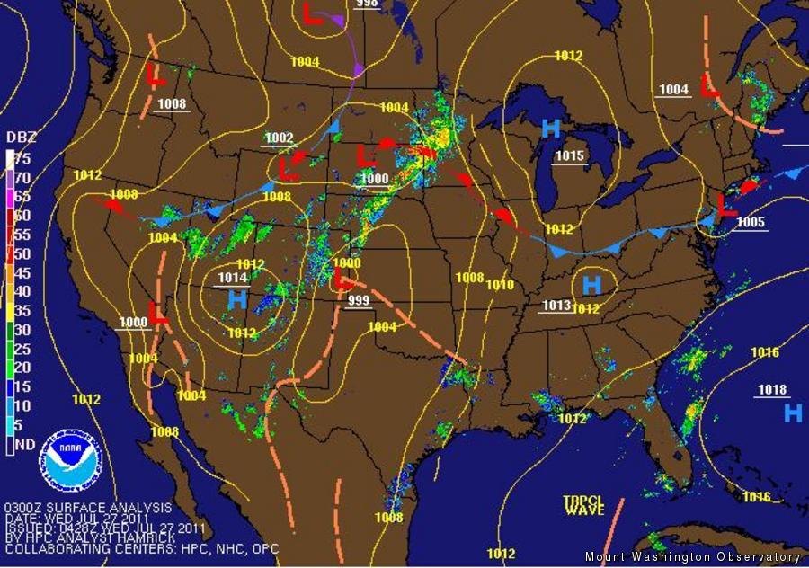
Computer Model Generated Analysis
Forecasting is a science, but is also very much an art.
Wikipedia defines science as a systematic enterprise that builds and organizes knowledge in the form of testable explanations and predictions about the world.
These so-called explanations and predictions we consistently produce, day in and day out, are put to the test as mother nature’s events unfold over a forecast period of 36 hours.
The scientific method is as follows:
1. Define a Question: Will any precipitation fall over the next 36 hours? How much cloud cover will there be in that time period? Is there a chance of thunderstorms over the next 36 hours? How will the temperature trend over the course of the period? How will the wind speeds and directions change over the next 36 hours?
2. Gather Information and Resources: For any forecaster, model data is essential to the forecasting process. This can come in the form of forecast maps, discrete numbers, and atmospheric soundings. There is a plethora of information available to the general public, but knowing how to interpret and use these tools effectively is a challenge.
3. Form a Hypothesis: This is where the ‘art’ comes in…
Although the model data, forecast maps, soundings, etc., are made up of discreet numbers and graphics, the interpretation of these tools has quite a subjective nature. The transformation from model data to the worded forecasts we produce and display on the website can be fairly straightforward for patterns that are recognized as ‘familiar’ (example: a strong ridge of high pressure overhead generally results in clearer weather, with gradually moderating temperatures and light winds). There are exceptions to every rule, but familiar patterns give us an excellent place to start.
For more complicated and multifaceted weather scenarios, forecasting truly becomes an art. Drawing from past experience and general meteorological knowledge, a forecaster must make critical decisions about the priority and strength of each weather feature, and what the interaction between these factors will result in. Just as an artist sits down to a blank canvas, when a forecaster sits down to craft a forecast, one really has no idea how the forecast will evolve as more and more references are drawn upon. In essence, the final product can be related to an artist’s finished portrait, with all of its nuances, idiosyncrasies, and subtle details incorporated into one ultimate work.
From there, the scientific method takes over once again, and the ‘hypothesis’ that is the forecast is tested by mother nature herself. The mark of a good forecaster is one that continues with the scientific process after the forecast period has passed, and analyzes their performance, determining what might have gone wrong, and why.
Mike Carmon, Observer / Meteorologist

Seek the Peak Spotlight: Ryan Shepard
Seek the Peak Spotlight: Ryan Shepard By MWOBS Staff Before Ryan Shepard moved to Conway, he was in Western New York celebrating his 40th birthday party. “I wanted to go big,” he said. “Big”

From Florida Heat to the Rockpile
From Florida Heat to the Rockpile By Alek Libby Hi everyone! My name is Alek Libby, and I am one of the summit interns here at Mount Washington Observatory this summer! I recently graduated

Summit Summer
Summit Summer By Aspen M. Hello everyone! My name is Aspen, I’m one of the summer weather interns here at the Mount Washington Observatory. I fell in love with weather at a young age
