
Auto Road Research/Hike
2008-05-09 23:09:55.000 – Matthew Morin, Space Grant Intern

Auto Road in May
Today was not a normal day at the office. In fact, no day here ever is. However, on this day I had a special task which would require brawn rather than brain. The weather was just about perfect for what I was planning. At 11 am, the temperature was around 40°F, winds were light by summit standards, and skies were partly cloudy. Perfect spring hiking weather! Rather than programming for hours on end or analyzing 1.5 million lines of temperature data, I had the opportunity to step out of the office. I needed to hike from the summit down 1,000 vertical feet via the Auto Road. That might sound amazing to some people, but it’s really not. The walk only took 25 minutes which included frequent stops to take care of another task that I was given.
At the request of the Director of Summit Operations, I stopped during my hike to set up wooden poles that had fallen over along the Auto Road. These poles are needed in certain locations as a guide for hikers and vehicles in dense fog or any other type of visibility limiter.
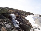
This hike was required so that I could visually inspect the 5300’ ARVP site. Each site, with the exception of the summit, has two collocated temperature sensors for use in the Auto Road Vertical Profile (ARVP). I noticed early on in my ARVP research that this site (and possibly other sites) had frequent disagreements in temperatures reported by each sensor. I created a graph of an example of the difference between each sensor’s reported temperatures. Archived weather data shows that sunny skies coincide with larger differences. This leads me to believe that there is a radiation problem for one of the sensors. Each sensor has a radiation shield which is supposed to alleviate such issues. However, a dirty shield will have a lower albedo (ability to reflect sunlight) than one that is clean. My hope was that all I would have to do is clean the shield and all would be well with the temperature data. Ultimately, that wasn’t the case.
When I reached the 5300’ site, I had a flashback of the first time I hiked to this location back in February. The snow was now mostly gone and in its place was lichen-covered rocks with patches of sedge. After I was done taking in the scenery, I got back to the task at hand. I carefully cleaned the radiations shields with isopropyl alcohol. I was a little concerned about how little dust there was. I then had a feeling that this wasn’t the cause the disagreeing reported temperatures. Therefore, I inspected the site for other potential causes of inaccurate data. I found and noted a few of my new suspicions.
After a tiring one hour brisk walk back up the Auto Road, I was back in the office pouring over more ARVP data. Though my efforts today did not solve the original problem, they did help in providing more clues that will be used to further investigate this issue. Also, I’m currently feeling great thanks to the workout I received from my little hike.
*For a brief description of the Mount Washington Auto Road Vertical Profile (ARVP), visit http://www.mountwashington.org/weather/arvp/.
Matthew Morin, Space Grant Intern
What the Rockpile Taught Me (Besides How to Dress for the Arctic)
What the Rockpile Taught Me (Besides How to Dress for the Arctic) By Kathryn Hawkes It turns out that living on the top of a mountain will teach you A LOT of things. How
Hiker Safety
Hiker Safety By Fawn Langerman, Dave Fatula and Julie Saccardo USFS Trailhead Steward volunteering season has begun, and hiker safety is on my mind. Truthfully, hiker safety is always on my mind, but more
Watch Our 2026 Annual Meeting and Read About the Highlights
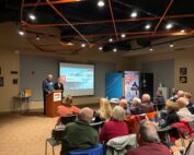
Watch Our 2026 Annual Meeting and Read About the Highlights By Drew Bush United States Representative Maggie Goodlander headlined Mount Washington Observatory’s 2026 Annual Meeting, and she set the tone right from the start.
