
Changes in the snowpack…
2007-03-15 07:28:50.000 – Jim Salge, Observer

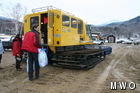
First sign of mud season at the base…
Less than a week after ending our 60+ day streak without hitting the freezing mark, we find ourselves in a 24 hour period without going below freezing. In fact, the high temperature of 43 degrees yesterday tied the record high for the date.
The mountain had a much different look yesterday as we ascended for shift change. Many bare spots, plenty of slush, some runoff, and the beginning of mud season down low, as evident from this picture. It’s all part of the highly changeable weather patterns that you expect around the beginning of spring. Though extreme temperatures swings are common all times of year on the mountain, late March and April tend to see those swings traverse the freezing mark, leading to dramatic changes in snow pack.
The freezing mark will again be traversed this morning as temperatures plummet behind this cold front. Rain will change to snow, before clearing skies this afternoon should give a dramatic sunset view on our new West View Camera. More snow is then likely tomorrow night, and cold air will rule out for the rest of the shift. I guess the guys on the other shift were on to something…
Jim Salge, Observer

Seek the Peak Spotlight: The Cloud Chasers
Seek the Peak Spotlight: The Cloud Chasers By MWOBS Staff Mike Bergeron and Desiree Bolton have been participating and volunteering for Seek the Peak for three years now. Together, they comprise Team Cloud Chasers

Celebrating 250 Years: The Declaration’s Legacy in the White Mountains
Celebrating 250 Years: The Declaration's Legacy in the White Mountains By Peter Crane We are now approaching July Fourth, Independence Day, the day when we celebrate the adoption of the Declaration of Independence in

Seek the Peak Spotlight: Ryan Shepard
Seek the Peak Spotlight: Ryan Shepard By MWOBS Staff Before Ryan Shepard moved to Conway, he was in Western New York celebrating his 40th birthday party. “I wanted to go big,” he said. “Big”
