Cut Offs
2010-03-21 04:37:47.000 – Mike Carmon, Staff Meteorologist
Lonely Low Left Listless
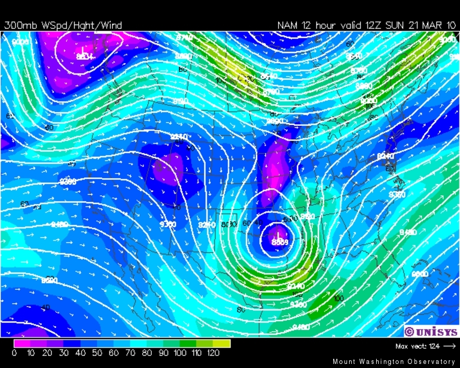
During my nightly forecasting ritual during the wee hours of Saturday morning, I was sifting through some prognostic forecast maps, and subsequently gasped in horror. The reason? It appeared a phenomenon known as a ‘cut-off’ low pressure system would plague the eastern half of the U.S. for the next week. Thus the inspiration for this comment was born–cut-off lows, which are the bane of any forecaster’s existence.
According to the American Meteorological Society, a cut-off low is defined as ‘a cold low that has grown out of a trough and become displaced out of the basic westerly current and lies equatorward of this current.’
As waves of energy traverse across the continental United States, ridges and troughs form in the main westerly flow. Upper-level troughs of low pressure often coincide with low pressure areas at the surface. Occasionally, if the dynamics of the atmosphere are correct, these surface lows develop and strengthen into dynamic weather-producing entities thanks to a synergy with the upper-level feature. The surface low will follow the path laid forth by the upper-level pattern, ideally with the upper-level low following just behind it. This movement and coincidental development continue until the upper-level trough catches up to the surface low. At this point in time, it is said the system has become vertically stacked, which is an indication the system is in the waning stages of its life cycle.
Once in a while, the low can be left behind by the main flow if there is a sudden shift in upper-level winds to higher latitudes. The consequence is a low pressure complex with no upper-level mechanism to steer it. These storms can thus meander around for several days, in some cases, advancing, then retrograding, then advancing again over the same regions, because there is no distinct flow to guide them. Forward movement of these storms is agonizingly slow, and can produce days and in some cases weeks of gloomy weather over the same locations. Despite general cloudy conditions along with areas of light to moderate precipitation, these cut-off systems generally lack any muster, so the weather does not turn severe.
Because the equations that guide forecasting models rely heavily on the atmospheric dynamics of an overall idealized flow, they have an awful amount of trouble handling cut-off lows in their prognoses. In most cases, a forecast that involves a cut-off low pressure system can come down to a forecaster’s best guess, which may be educated, but is still a guess. Many a forecast can be rendered completely inaccurate thanks to these rogue systems that will loiter around until the upper-level pattern shifts and manages to eject them out to sea.
Now you can understand my gasp of horror a bit more, and maybe cut your local weather forecaster a bit of slack if s/he alludes to a cut-off low pressure system in their discussion!
Mike Carmon, Staff Meteorologist
Three and a Half Months of Snow, Ice and Rime
Three and a Half Months of Snow, Ice and Rime, with Deeper Drifts. By Ryan Steinke Me outside on the summit near the Yankee Building. My internship with the Mount Washington Observatory
Supporter Spotlight: Righteous Vices Coffee Roasters
Supporter Spotlight: Righteous Vices Coffee Roasters By MWOBS Staff Righteous Vices Coffee Roasters, a local coffee roaster and shop located in Center Conway, New Hampshire, has been a partner of the Observatory since 2024.
Winter Storm Tracks Across New Hampshire
Winter Storm Tracks Across New Hampshire By Alex Branton As winter comes to a close, most of us are ready for the warmer temperatures and sunshine that come with Spring and Summer. Although we


