
Déjà vu!
2015-01-01 17:40:43.000 – Kaitlyn O’Brien, Weather Observer/Education Specialist
While everyone is likely focusing on the fresh start of a brand new year, it is looking like Mother Nature is reflecting extra carefully on 2014. Remember that rainy Christmas Day most of New England experienced just one short week ago? Models are indicating the formation of an area of low pressure that will likely affect us during the second half of the weekend. Right now, it’s looking like the center of the low will once again be positioned over the Great Lakes, putting much of New England in the warm sector of the storm. But with a strong Canadian high in place prior to the arrival of this low, models are showing that temperatures may be cold enough for snow, with a transition to freezing rain possible when the associated warm front lifts north and causes temperatures to rise during the day on Sunday. As the low continues to track northeast, a cold front is expected to swing through Sunday evening into early Monday morning, lowering temperatures once again and allowing any remaining precipitation to fall as snow. Below are graphical forecasts for what to expect this weekend, courtesy of the National Weather Service.

Kaitlyn O’Brien, Weather Observer/Education Specialist
Home Sweet Summit
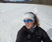
Home Sweet Summit By Kathryn Hawkes Me enjoying the view of Mount Washington while skiing in the valley on my off week. Hi everyone! My name is Kathryn Hawkes and I’m the

Meet MWOBS/MWAC Intern Ryan Tanski
Meet MWOBS/MWAC Intern Ryan Tanski By Ryan Tanski Hello! I’m Ryan Tanski and I’m the joint USFS Mount Washington Avalanche Center and Mount Washington Observatory Intern this winter. I’m thrilled to get to work

Geologist Climbs Rock Pile, Looks Up
Geologist Climbs Rock Pile, Looks Up By Bailey Nordin Hello from the summit of Mount Washington! My name is Bailey Nordin, and I am the newest Weather Observer and Education Specialist joining the team
