
Delta’s Remnants Brings A Series Of Remarkable Weather Phenomena To The Summit Of Mt. Washington.
2020-10-14 06:32:37.000 – Jay Broccolo, Weather Observer/Meteorologist
Hello everyone!
Last night I was working on a blog about my experience hiking Mt. Whitney and going to Badwater Basin in Death Valley. I thought it might be interesting for some people to hear about some of the weather that sparked off a series of storms over Sequoia and Inyo National Forests, which went on to start a series of unprecedented wildfires out west. Maybe you wanted to see some pictures of the weather station at the lowest point in the United States that recorded the highest temperature ever recorded on Earth at 129.9° F on the 16th of August, 2020. The 134.1 recorded back on July 10th, 1913 has been in question for some time now. We ONLY experienced temperatures as high as 127° F. If there is interest in this, then I can post it a little later, but for now…
Fast forward to this morning, October 13th, 2020. I decided to put the writing I did the night prior on hold. I apologize for the tease if you were interested in the above topic, but I think you will appreciate this as well.
It began as a beautiful morning with another striking sunrise. Not so beautiful that it made other striking sunrises less notable, but an uncommon sunrise nonetheless. There were not many clouds aloft. We could tell that cloud cover was increasing and there was certainly some moisture to the southeast, marked by lower visibility. Winds were southerly and they appeared to be southeasterly in the valley as we watched the undercast roll over the Carters and Wildcat towards the northwest. A little higher up and several hundred feet above Northern Presidential Mountains were constantly changing wispy lenticular clouds with intersecting flows creating these intricate cloud formations. Naturally, we snapped some photos.
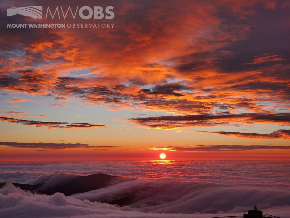
Sunrise occurred at 0551EST (0651EST), and the morning radio call, where we call out the weather to all the huts from the AMC, RMC, and other listeners, was at 0700EDT. Sometimes it is tough to catch the sunrise when it rises during actual work activity. As I came in to prepare for the radio call, I noticed the beginnings of a rainbow forming over Mt. Willey and Field. It was lacking the blue and green color but was developing so I went up to the parapet to snap a couple of photos of the rainbow before the radio call. I only had a couple of minutes, but this is what I managed to snap beforehand.
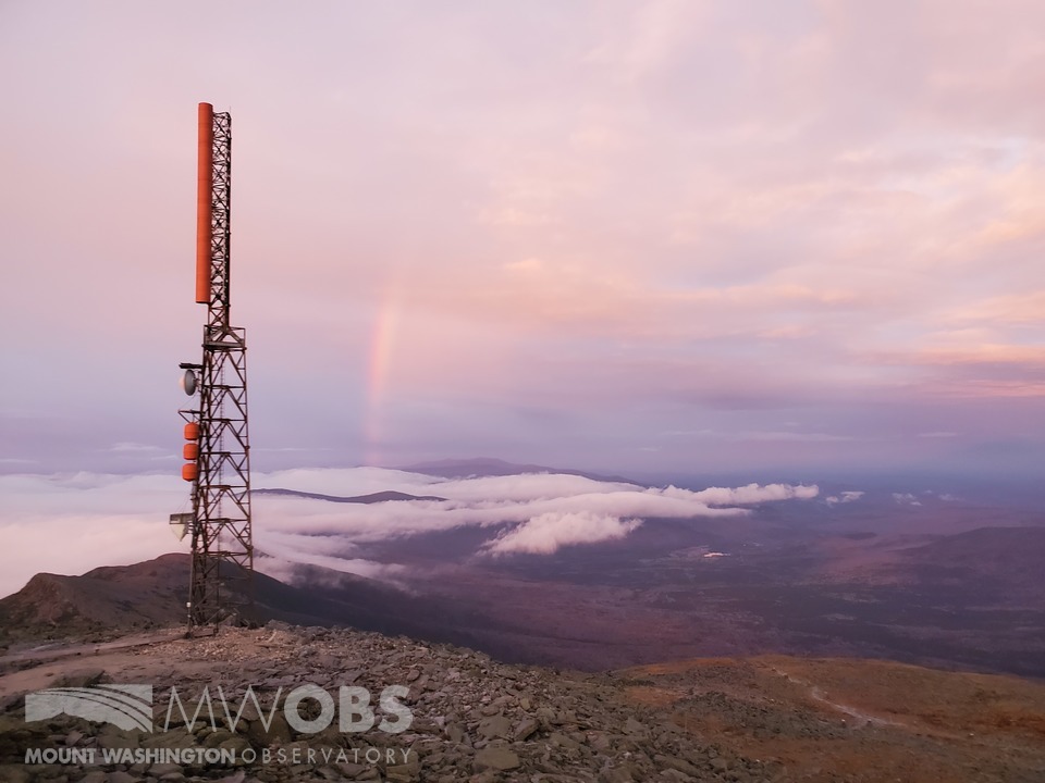
During the radio call, I was watching the rainbow continue to develop while calling out the weather. It usually takes about 10 to 15 minutes to go through all the relevant data and forecast information. That can be the entire life span of a rainbow; they are finicky things really. About halfway through, I noticed ANOTHER rainbow what looked to be coming out of the Great Gulf. I looked back towards the west at Mt. Tom, Field, and Willey and there is a double rainbow. This is just nuts. Maybe it’s just me and I’m not claiming this to be true all the time, but in my almost 2 years here, I’ve seen the Aurora Borealis more than I’ve seen Rainbows, and here I am looking at 3. All the while “Winds will be south shifting NW at 25 to 40 mph…” I did mention it on the radio, just in case any of them could see it too. Even my co-worker Nate came in to tell me how awesome it was up on the observation deck of the State Park Building.
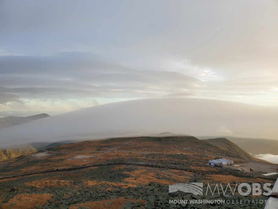
Once finished with the radio call I headed up to the observation deck and proceeded to take many pictures. The first thing I noticed was the upslope rain showers. The skies were becoming increasingly cloudy with the clouds below the summits moving ever closer from the south. The air was extremely dry ahead of the rain. The lower level clouds sitting around 4000 feet almost completely evaporated into the air on the approach to the summit before I head into the weather room for the radio call earlier. Now, moisture was lifting up over the summit and compressing, condensing, and spitting out some rain. As the winds picked up a bit, those wispy lenticulars that were forming over the Northern Presidentials were now forming over Mt. Washington. Constantly changing, thin layers of clouds rushing over the summit and then sinking down into the Great Gulf where the pressure was lower.
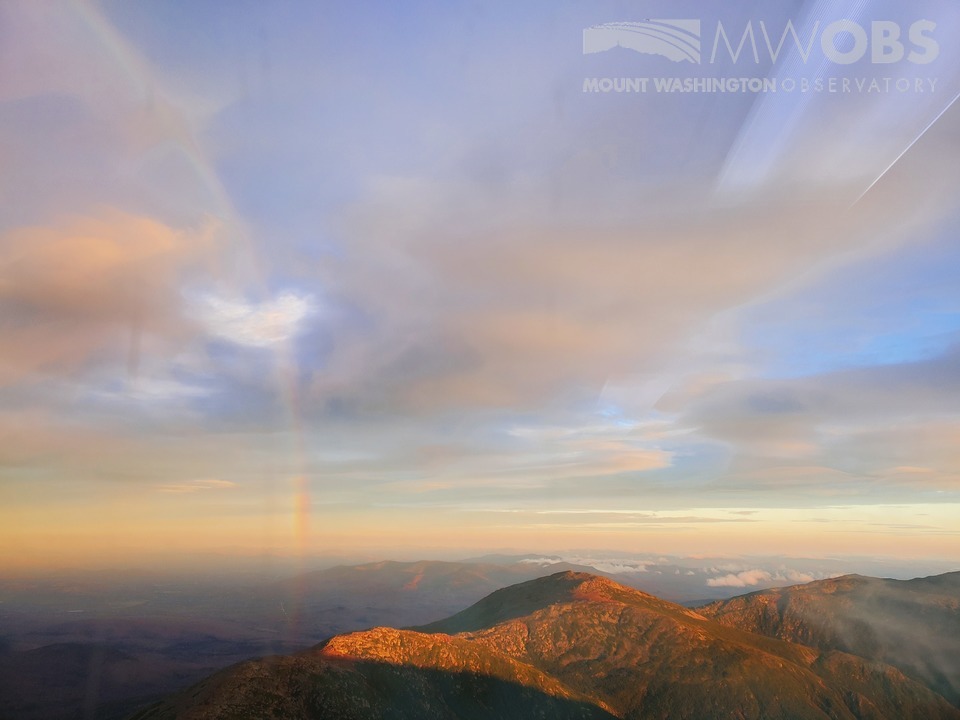
The next thing I noticed was all the lenticulars around. They were everywhere and made the sky look like it was a massive mountain range covered in snow similar to the Alps or Rockies, except in the sky. Then to top it all off, those three rainbows I saw earlier were actually all part of the same Rainbow. A near 200° colorful display of shimmering, reflecting, refracting, and dispersing light from the oncoming moisture wave rose out of the Great Gulf over Willy and Field, stretching up into the sky as the lenticulars flowed through. A secondary one had formed a bit further south down route 302 but faded along the upward curve. Anyone of these three events or phenomena were quite spectacular on their own. Witnessing all three around the same time was almost too much emotion to handle.

Jay Broccolo, Weather Observer/Meteorologist

Seek the Peak Spotlight: The Cloud Chasers
Seek the Peak Spotlight: The Cloud Chasers By MWOBS Staff Mike Bergeron and Desiree Bolton have been participating and volunteering for Seek the Peak for three years now. Together, they comprise Team Cloud Chasers

Celebrating 250 Years: The Declaration’s Legacy in the White Mountains
Celebrating 250 Years: The Declaration's Legacy in the White Mountains By Peter Crane We are now approaching July Fourth, Independence Day, the day when we celebrate the adoption of the Declaration of Independence in

Seek the Peak Spotlight: Ryan Shepard
Seek the Peak Spotlight: Ryan Shepard By MWOBS Staff Before Ryan Shepard moved to Conway, he was in Western New York celebrating his 40th birthday party. “I wanted to go big,” he said. “Big”
