
Detecting Lightning on the Summit
2016-06-30 20:42:33.000 – Adam Gill, Weather Observer/IT Specialist
Over the past few days we have had thunderstorms that have passed over or near the summit. Lightning is a very real danger above tree line; due to how exposed you are, you increase the possibility of getting struck. At the Observatory, lightning is one of the only reasons that we will not go outside to do an hourly observation. So, we have to know if there is going to be lightning soon. This past week, we installed our Electric Field Meter (EFM) in an effort to detect the charge of the atmosphere, which will give us forewarning of a building electromagnetic field near the summit. Below are a few examples of what the EFM was reading during a thunderstorm.
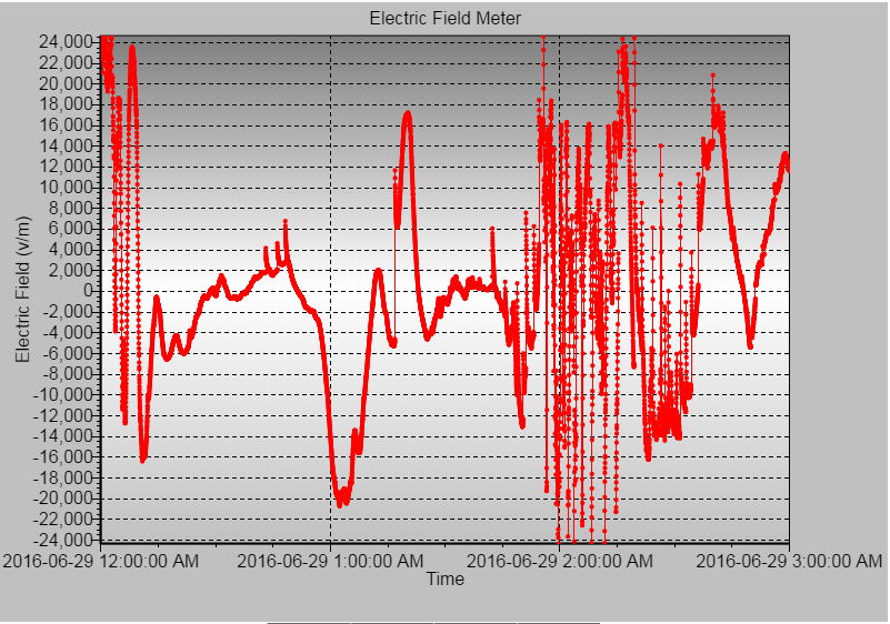
During the thunderstorm in which this data was captured, there were 8 lightning strikes that hit the summit with rapid fluctuations between +20,000 volts per meter and -20,000 volts per meter. The possibility of a lightning strike exists when the electromagnetic field gets over +/- 2,000 volts per meter.

The second thunderstorm didn’t have any direct strikes, but we did have a strong thunderstorm pass just to the south of the summit.
With the EFM, we have the possibility of detecting conditions in which lightning strikes could be imminent. However, we need to know well in advance if there is even a chance of seeing thunderstorms so we can warn anyone who is planning to hike up or coming up in a car so they can plan accordingly.
To do that, we use computer models to look at the state of the atmosphere to determine what type of weather we will see. There are several computer models that we use that individually have their strengths and weaknesses, depending on their resolution and how many vertical layers of the atmosphere that they interpolate. Using all of models as well as personal experience of the forecasters, our summit meteorologists create the higher summits forecast.
Looking ahead at the 4th of July weekend, it is looking like there are good chances for thunderstorms once again over the state, especially Friday evening into Saturday morning. Below is a vertical profile of the atmosphere near the White Mountains called a Skew-T/Log-P diagram, which graphs temperature (solid red line) and dew point (solid green line). The dotted line represents the path an air parcel will take if it becomes unstable. In this diagram, the dotted line is warmer than the environmental temperature. So much like a hot air balloon, a parcel of air lifted from the surface will continue to rise until the temperature is equal to the environmental temperature. The area between the dotted line and the environmental temperature is called CAPE (convective available potential energy), which can indicate favorable conditions for thunderstorms, as well as the strength of the updraft. With this forecasted sounding, it is a good indication that there will be thunderstorms in the area tomorrow afternoon into the evening. This does not mean a thunderstorm will hit the summit though, because thunderstorms are random and can pop up anywhere in a broad region of unstable air. One thunderstorm can create a large area of rain-cooled air that can suppress thunderstorm activity around it by reducing the energy available.

Adam Gill, Weather Observer/IT Specialist

Seek the Peak 2026: New Adventures, Rooted in Tradition
Seek the Peak 2026: New Adventures, Rooted in Tradition By MWOBS Staff Seek the Peak is Mount Washington Observatory's largest annual fundraiser, and for 26 years it's brought together hikers, adventurers, and people who

What “Prepared” Really Means in the White Mountains
What “Prepared” Really Means in the White Mountains Early Spring in the Whites: The Most Honest Season By Andrew Harris, Burgeon Outdoor If you’ve spent any time in New Hampshire’s White Mountains in March,

March on Mount Washington
March on Mount Washington By Ryan Knapp Looking towards Mt. Madison at sunset on March 21, 2026. The calendar has spoken: Friday, 20 March 2026, marked the first day of astronomical spring.
