
DMC
2010-05-24 17:29:20.000 – Mike Carmon, Staff Meteorologist

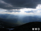
Crepuscular Rays
With the absence of my counterpart meteorologist this shift, my skills in predicting the unpredictable have been especially on call. Luckily, the presence of a formidable and stubborn ridge of high pressure over the eastern half of the Continental U.S. has provided us with pretty mundane but gorgeous weather for most of the shift. I have lamented with my co-workers that I’m running out of ways to put into words the fact that skies will be sunny and temperatures will be warm. But I should not complain, because before long, some form of wild weather will return with a vengeance, and I’ll be pulling my hair out trying to produce an accurate forecast.
It’s all part of the fun, though. I awoke this afternoon and offered to help Steve out with the afternoon forecast, as it appears conditions will get much more interesting than “in the clear under mostly sunny skies.” A cold front is looming, sneaking in through the back door, and this could give us a shot at a thunderstorm late tomorrow and early tomorrow night.
There are three ingredients a forecaster will look for when trying to predict convective activity (a.k.a. thunderstorms):
1. Instability: An unstable atmosphere is one in which air parcels, when prompted, will become warm enough to obtain buoyancy and rise indefinitely. This is a product of the rate at which the ambient air cools as one ascends through the atmosphere. A rapidly cooling vertical temperature profile coupled with very warm temperatures near the surface provides excellent instability.
2. Moisture: Clouds form when this instability is present and rising parcels cool, permitting the water vapor within them to condense into water droplets. If moisture is lacking, rising parcels of air will do no good.
3. Lift: The first ingredient, instability, contains the caveat “when prompted” in its description. That’s where lift comes in–some form of lifting mechanism needs to be present to provoke parcels contained in an unstable air mass to begin an upward motion. The most common type of lifting mechanisms are boundaries of some kind–cold fronts, warm fronts, dry lines, etc.
Because of the uncharacteristically (possibly record-breaking) warm weather, plenty of instability will build up through the day tomorrow. Copious moisture has been ushered in for days, and with the approach of the cold front, all three ingredients seem to be merging to result in a thunderstorm scenario. Unfortunately, the cold front is quite a weak one, so this has seriously reduced the risk for thunderstorms in the valley. However, orographic lifting (lifting of air as it passes over a mountain) could augment our chances for a few rumbles of thunder. It would be a great way to close out this shift week!
Mike Carmon, Staff Meteorologist

From Florida Heat to the Rockpile
From Florida Heat to the Rockpile By Alek Libby Hi everyone! My name is Alek Libby, and I am one of the summit interns here at Mount Washington Observatory this summer! I recently graduated

Summit Summer
Summit Summer By Aspen M. Hello everyone! My name is Aspen, I’m one of the summer weather interns here at the Mount Washington Observatory. I fell in love with weather at a young age
From the Sunshine State to the Home of the World’s Weather
From the Sunshine State to the Home of the World's Weather By Kristen Mihalcik Hello Everyone! My name is Kristen Mihalcik, and I’m one of the Summer interns here at Mount Washington. Enjoying
