
Here Comes the Snow
2009-03-01 17:05:55.000 – Brian Clark, Observer and Meteorologist

Close call
For someone like me, that not only loves the weather but also loves snow (a lot), the anticipation of an impending snow storm is sometimes hard to bear. With how good the operational forecasting models have gotten these days, that hightened anticipation can sometimes start as much as 3 days before the storm’s arrival. However, with the way the models have been performing this winter, especially in the 3-5 day range, I was very hesitant to latch onto the current impending snow storm when it started showing in the models on Wednesday and Thursday. Now that we are a mere 12 hours from the arrival of the storm, I am now in full snow storm mode.
One thing that probably contributed the models having a tough time coming up with a solution for the storm was the complexity of it. For a while, only one low pressure center was being shown coming up the Atlantic Coast. Then as the days went by, a second low pressure center began to show up, trailing behind the first. It then became clearer yesterday that the first low would be the weaker of the two and the second would be the one to watch.
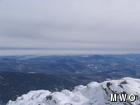
That first storm not only ended up being rather weak, but also stayed just far enough offshore this afternoon to prevent us from seeing any snow (unlike southern NH). However, as you can see from the picture attached to this comment, we weren’t too far from getting some snow showers. The clouds you see pictured below the summit were associated with precipitation attached to that first coastal low, and came as close as about 40 miles away early this afternoon.
The second stronger low will move in tonight and that’s when the fun begins. Although southern NH will see more snow than we will, I am still anticipating at least a moderate snowfall of around 6-8 inches here on the summit. At the very least, it will be enough to freshen things up after the nasty mix of freezing rain, sleet, and snow we saw with the storm that came through late last week.
This storm will also give the new group of German students that just arrived today a chance to experience some interesting weather!
Brian Clark, Observer and Meteorologist

Team Flags Return for Seek the Peak’s 25th Anniversary
Team Flags Return for Seek the Peak's 25th Anniversary By MWOBS Staff Mount Washington Observatory is looking forward to continuing a much-loved tradition for Seek the Peak’s 25th Anniversary: Team flags. In inviting teams
Meet Summer Interns Zakiya, Max and Maddie
Meet Summer Interns Zakiya, Max and Maddie By MWOBS Staff We are excited to welcome six teammates to the summit of Mount Washington this summer! During their internship, these students and graduates will play

Saying Goodbye to the Summit
Saying Goodbye to the Summit By Alexis George After an extraordinary last three years working as a Weather Observer and Meteorologist, I am excited to pursue a different career. As sad I as am
