
Impending Ice
2010-01-24 18:14:09.000 – Mike Carmon, Staff Meteorologist

NULL
Although this is not meant to be a forecast discussion, it will probably sound awfully like one to y’all.
As I sat composing this string of thoughts this afternoon, clouds (some of them lenticular) were quickly thickening and lowering all around the summit. We are gearing up for a 24 hour visit from a massive storm system beginning tonight.
We’ve been fortunate enough to enjoy a phase of calm, clear weather since we emerged from the fog on Thursday morning. We have reported a visibility of at least 100 miles for 65 out of the last 76 hours (Thursday afternoon through Sunday afternoon), and have reached 130 miles for 23 of those 65 hours. Amidst this exceptionally clear weather, there was a 16 hour period in which there was not a single cloud in the sky. Observations consisted of little more than a temperature reading.
However, the winds of change have caught word of the uncanny string of immaculate weather the ‘home of the world’s worst weather’ has been experiencing, and are about to smack us over the proverbial head with a wake up call. At the onset Sunday night, precipitation will begin as a messy muddle of snow and sleet. Temperatures will escalate throughout the overnight hours, encouraging the snow and sleet to morph into a mix of sleet and freezing rain, creating a situation that this shift is all too familiar with-a severe glaze icing event. It appears terribly reminiscent of the scenario we witnessed about a month ago during Christmas week, when, at its peak, the storm system produced over 5 inches of heavy glaze ice per hour! Because this storm is teeming with moisture, these remarkable accumulations could be matched or possibly even exceeded!!
But hold on…that’s only half of the fun we’re preparing for! The mercury will continue to inch skyward on Monday, which will sanction a change from freezing rain to plain rain. Models are indicating that we could easily see 2 inches or so of liquid equivalent precipitation, which will work very diligently at eating away our 19 inch snow pack. On top of that, we are expecting south winds for a length of time, which tends to send water flooding (pun intended) into our tower.
Finally, there’s the wind, which seems to have been out to lunch so far this young year. Winds look to be sustained just above 80 mph Monday afternoon, with gusts surpassing 90 mph, and a chance we could see the first 100 mph gust of 2010. I’m not exactly optimistic about hitting the century mark, but this mountain has without a doubt surprised me many a time before.
So now, we wait for the return of exciting weather…
Observer Note: Due to the possible heavy icing conditions combined with south-to-southeast winds, there is a possibility that the summit will loose its internet connection Sunday night and/or Monday. If this does occur, the current summit conditions will not update until this connection is restored. We apologize for the inconvenience.
Mike Carmon, Staff Meteorologist
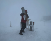
The Precip Can: Measuring Rain, Snow, and Everything Else on Mount Washington
The Precip Can: Measuring Rain, Snow, and Everything Else on Mount Washington By MWOBS Staff Averaging 281 inches of snow per year, the Observatory is no stranger to measuring precipitation. While it might be
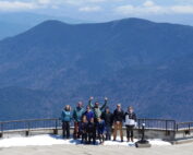
Meet MWOBS’ 2026 Seek the Peak Teams
Meet MWOBS’ 2026 Seek the Peak Teams By MWOBS Staff Another year, another epic Seek the Peak! As of June 2026, there are 430 hikers signed up for Mount Washington Observatory's annual summer fundraiser and
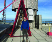
What the Rockpile Taught Me (Besides How to Dress for the Arctic)
What the Rockpile Taught Me (Besides How to Dress for the Arctic) By Kathryn Hawkes It turns out that living on the top of a mountain will teach you A LOT of things. How
