
Just Another Spring Day
2013-05-17 17:18:26.000 – Mike Carmon, Weather Observer/Meteorologist

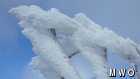
Today’s Rime Ice
Winter is back…again!
Or is it? Actually, it’s just another spring day on Mt. Washington.
Today, we’ve received freezing drizzle, freezing rain, ice pellets (sleet), and snow, accumulating to six-tenths of an inch.
How odd is that? Well, considering Mt. Washington averages 12.5 inches of snow for the month of May, it’s not so strange.
Temperatures have hovered in the 25-30 degrees F range throughout the entire day, which, when coupled with thick fog, has resulted in significant rime ice and glaze ice accumulation on top of the summit. Overnight last night, the freezing level reached down to as low as 4000 feet, which has turned the higher summits white once again!
However, glancing ahead in the models, Mt. Washington’s notoriously temperamental climate will have yet another mood swing in the coming days. A warm front has its sights set on New England, which should bring temperatures to above-average levels by early next week–with perhaps the mercury rising into the 50s.
All of that ice and snow will be history before it has any chance to get comfortable!
Mike Carmon, Weather Observer/Meteorologist

Seek the Peak Spotlight: The Cloud Chasers
Seek the Peak Spotlight: The Cloud Chasers By MWOBS Staff Mike Bergeron and Desiree Bolton have been participating and volunteering for Seek the Peak for three years now. Together, they comprise Team Cloud Chasers

Celebrating 250 Years: The Declaration’s Legacy in the White Mountains
Celebrating 250 Years: The Declaration's Legacy in the White Mountains By Peter Crane We are now approaching July Fourth, Independence Day, the day when we celebrate the adoption of the Declaration of Independence in

Seek the Peak Spotlight: Ryan Shepard
Seek the Peak Spotlight: Ryan Shepard By MWOBS Staff Before Ryan Shepard moved to Conway, he was in Western New York celebrating his 40th birthday party. “I wanted to go big,” he said. “Big”
