
Lenticular Clouds
2012-02-04 08:46:56.000 – Rebecca Scholand, Operations Assistant

NULL
With the valley under the clouds and the summit above it felt like we were in a mountainous castle with a cloud moat. Today was not much different in that we still had an undercast with breaks here and there but the clouds above were impressive. The sky was filled with seemingly stationary lenticular clouds. Some were pancaked in appearance, some UFO like, and others stretched across the sky.
A lenticular cloud is a type of stationary lens shaped cloud that forms at high altitudes, typically in stronger winds, and normally downwind of a mountain range. Here the flow of the air has a wave like motion as it rises and falls. At the windward edge of the cloud the air has been raised and cooled enough to form a cloud, however on the leeward side of the cloud the air has sank and warmed enough that the moisture turns back into vapor and the cloud dissipates. This is what gives the cloud its stationary look when in fact it is constantly changing.
Brian Clark was able to film a time lapse of this happening today. To check it out visit our YouTube site.
Rebecca Scholand, Operations Assistant
Home Sweet Summit
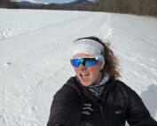
Home Sweet Summit By Kathryn Hawkes Me enjoying the view of Mount Washington while skiing in the valley on my off week. Hi everyone! My name is Kathryn Hawkes and I’m the
Meet MWOBS/MWAC Intern Ryan Tanski
Meet MWOBS/MWAC Intern Ryan Tanski By Ryan Tanski Hello! I’m Ryan Tanski and I’m the joint USFS Mount Washington Avalanche Center and Mount Washington Observatory Intern this winter. I’m thrilled to get to work

Geologist Climbs Rock Pile, Looks Up
Geologist Climbs Rock Pile, Looks Up By Bailey Nordin Hello from the summit of Mount Washington! My name is Bailey Nordin, and I am the newest Weather Observer and Education Specialist joining the team
