
Life as a Mesonet and Information Systems Technician
By Colby Morris
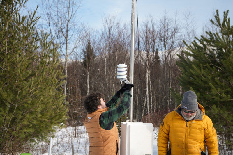
Installing an automated weather station with MWOBS Director of Technology Keith Garrett (left). The instrument I am holding is a temperature sensor.
From a young age, I was always fascinated by storms and other weather phenomena like hail and ground fog. I knew I wanted to understand how the weather formed and shaped the world around us. It helped that my father is a pilot; I always sat in the front seat, peering out the big glass window watching clouds go in and out of view. I listened to him explain the types of clouds, how they form, and how that affects the plane as we cruised through the sky. That interest in weather never seemed to escape me as my passion for technology grew more as I got older.
Living in the White Mountains, it was only fitting for my first web application to be a weather widget. That weather dashboard, primitive at the time, made me want to explore a more local system to monitor weather at home. This naturally led me to get my first home weather station kit. It was fascinating seeing the station’s anemometer move with the wind and for that data to be sent to my computer, where it was collected into a simple Excel file. As the rows grew with interesting data, I wanted to be able to use that information in a meaningful way.
At the time, we had a big greenhouse with roll up sides and exhaust vents, which are used to help moderate the temperature inside. I thought: What if I made my own little weather station to roll up sides and open the exhaust vents on based upon the current conditions inside the greenhouse, as the home weather station kit couldn’t report data fast enough. This led me to build my own Arduino powered system that had temperature and humidity sensors. I built the system with two sensors for redundancy, just to make sure the data it collected was as accurate as possible. This system was connected to a solenoid valve and controlled the rollup sides and exhaust vent. When the temperature or humidity hit a certain level, it would open the exhaust vent. Then, if the temperature continued to increase, it would open the rollup sides. It is these projects and problems that lead me to always have a love and interest in weather systems and how you can use data in meaningful ways.
Today, I work as a Mesonet and Information Systems Technician at Mount Washington Observatory (MWOBS), where I design, deploy, and maintain advanced weather stations across the state. This role lets me bridge the physical and digital worlds— both being passions of mine. You can find me on the weekends going on hikes, taking photos of the mountains, and staying up way too late waiting for the clouds to clear trying to capture astrophotography.
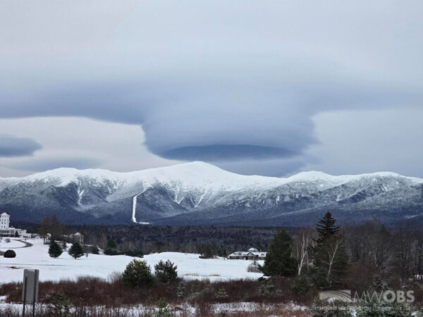
A very cool looking lenticular cloud over Mount Washington’s summit captured on 11/25/25.
Working for MWOBS has been nothing short of an adventure, from bringing me just a few miles from the Canadian border to fixing a wind battered station on the exposed mountain side of Mount Washington. Along with the amazing views of the 7.6-mile-long Mount Washington Auto Road, you can also find an array of six mesonet stations ranging from around 2,300 feet to 5,300 feet in elevation. These stations form the Auto Road Vertical Profile (ARVP), which were first deployed in 2003 and have given us a deeper understanding of local weather in the area. To ensure the data being collected is accurate and available, continuous maintenance is needed, and in the beginning of October 2025 all the stations were upgraded. These upgrades added new solar panels, soil sensors, and bigger batteries to help the stations stay online longer in harsh conditions and low light, as well as full replacement of all other components.
Along with building weather stations, I’ve also been tasked with building web applications that help make weather more accessible to everyone. One of those projects is the Northeast Network of Mountaintop Observatories (NENMO) project that links the Mount Washington Observatory with other prominent Mountain Meteorology teams such as the Whiteface Mountain Observatory in New York’s Adirondack Mountains and the University of Vermont Summit to Shore Environmental Observation Network. The challenge of bringing three separate mesonet networks together and displaying them for the use of hikers to professional applications is something I’m very excited about!
What drives me the most is the challenge of connecting data with purpose, whether it’s helping predict extreme weather events through the use of AI or streamlining our own weather station network with the use of an application programming interface (API). The idea that technology can solve real-world problems is important. I value resilience and curiosity, which comes in handy when troubleshooting sensors in a rainstorm or installing cameras on the top of the Observatory tower in 60mph winds.
At the heart of everything I do is a belief that technology isn’t just about code or hardware; it’s about the connection between people, systems, and the natural worlds we’re trying to understand. Using the skills I have, I can make the weather more accessible for everyone, from Mount Washington hikers to farmers trying to protect their crops from frost.
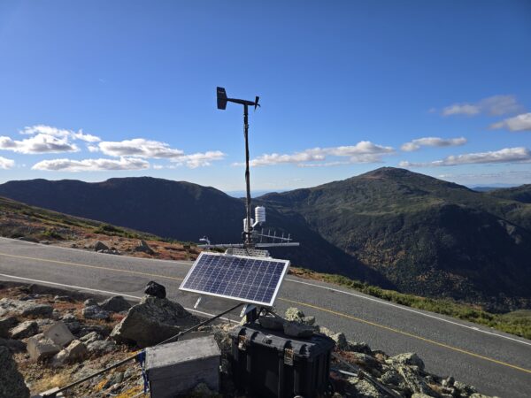
Weather station AR53 is located at approximately 5,300 feet from sea level next to the Auto Road and was upgraded on October 1st.

Seek the Peak 2026: New Adventures, Rooted in Tradition
Seek the Peak 2026: New Adventures, Rooted in Tradition By MWOBS Staff Seek the Peak is Mount Washington Observatory's largest annual fundraiser, and for 26 years it's brought together hikers, adventurers, and people who

What “Prepared” Really Means in the White Mountains
What “Prepared” Really Means in the White Mountains Early Spring in the Whites: The Most Honest Season By Andrew Harris, Burgeon Outdoor If you’ve spent any time in New Hampshire’s White Mountains in March,

March on Mount Washington
March on Mount Washington By Ryan Knapp Looking towards Mt. Madison at sunset on March 21, 2026. The calendar has spoken: Friday, 20 March 2026, marked the first day of astronomical spring.
