microburst
2007-08-26 13:26:42.000 – Dan Harnos, Summit Intern
Daily Hays Chart
Yesterday certainly proved to be a great day for observing the weather up here on Mount Washington. I awoke to the view of fog I’ve become accustomed to up here since we had been in it since Wednesday evening. After grabbing a quick breakfast though I returned to the weather room, and the fog had finally moved out! Of course there’s always a catch though, and we had mist for a few hours limiting visibility to 2 or 3 miles. Later in the afternoon the mist was replaced by haze and some breaks in the clouds occurred, and that is where things begin to get interesting.
When I awoke the temperature was 59 degrees, certainly well above average for the morning. With the little bit of clearing and continued warm air flowing in from the southwest we were able to tie the daily record high of 65 degrees, with the original being set back in 1947. Just a week ago we were talking about record lows and now we’re right back to record highs.
That wasn’t the end of the excitement however, as the moist unstable air continued to be heated thunderstorms began popping up across New York state. After a couple anxious hours of watching the radar and monitoring the situation it became time to go into the dreaded lightning shutdown along with a mad dash up into the tower to remove instruments before any possible damage. Finally everyone gathered by the windows in the weather room anxiously awaiting the storms arrival.
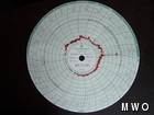
The summit wound up being glanced by the north end of a bow echo (named so due to its appearance similar to that of a bow on a radar display) which passed just to the south. The fog was not overly thick so unlike most storms the crew up here was able to actually discern lightning bolts on several occasions, rather than just seeing a typical flash. At the onset of the storm here we were hit by a microburst (a feature seen in strong, extremely tall thunderstorms which produces strong winds due to rain evaporating in the cool, upper regions of the storm which cools the surrounding air further and can cause it to sink rapidly). During this the winds picked up significantly for about 5 or 10 seconds, peaking at 93 mph before dropping back down to around 50 mph.
After the storm passed we were in for another treat, as the clouds began to become illuminated in yellow and orange glows as the sun was visible through the fog as it set off to the northwest. The weather room was quickly lit up by the fantastic colors as everyone gazed at the beautiful clouds.
We still weren’t finished however, as almost as soon as we had begun turning computers back on and returning to normalcy another line of storms approached shortly after dinner. These produced more rain and some decent winds, but paled in comparison to the earlier storm. Normally we would be extremely excited but it was rather ho-hum due to the great cell that struck us earlier. All in all it was certainly a lively day though!
Dan Harnos, Summit Intern
Team Flags Return for Seek the Peak’s 25th Anniversary
Team Flags Return for Seek the Peak's 25th Anniversary By MWOBS Staff Mount Washington Observatory is looking forward to continuing a much-loved tradition for Seek the Peak’s 25th Anniversary: Team flags. In inviting teams
Meet Summer Interns Zakiya, Max and Maddie
Meet Summer Interns Zakiya, Max and Maddie By MWOBS Staff We are excited to welcome six teammates to the summit of Mount Washington this summer! During their internship, these students and graduates will play
Saying Goodbye to the Summit
Saying Goodbye to the Summit By Alexis George After an extraordinary last three years working as a Weather Observer and Meteorologist, I am excited to pursue a different career. As sad I as am


