
Never Out of the Woods
2016-05-29 16:37:45.000 – Tim Greene, Summit Intern
Despite Tropical Storm Bonnie being the hot-button topic of most New England meteorologists’ concern this weekend, it can be said with fairly high confidence that the brunt of the storm will pass well south of us here in the White Mountains. Even the northernmost tracks forecast by the EPS and GEFS (ensemble models that run dozens of slight perturbations on the one initialized model, creating a series of outputs covering the whole spectrum of what could happen) keep the system roughly 100 miles offshore. In fact, mean sea level pressure is forecast to remain well above 1000 millibars (which roughly equates to 800 mb at the summit of Mount Washington) through much of New England. Large portions of the Carolinas and Virginia are forecast to get upwards of 3 inches of rain, though the heaviest rainfall is expected to stay offshore (in excess of 8 inches).
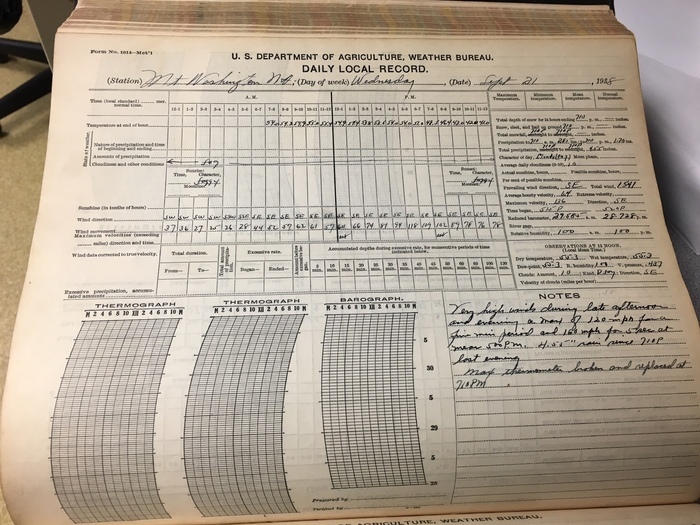
But what would happen if Bonnie plowed through the White Mountains? Moreover, what would happen if instead of Tropical Storm Bonnie it was Hurricane Bonnie that had Mount Washington in her crosshairs? Well, that is exactly what happened on August 31, 1954, except instead of Bonnie, it was Hurricane Carol that was the culprit. Southern New England saw sustained winds in excess of 100 mph and the Observatory gusted up to 142. More noteworthy though was the tropical rainfall Mount Washington saw; over 3 inches of it. The infamous New England hurricane known only as “38” (common practice before 1954, when hurricanes were not named as they are today; they were most commonly named after the area they most affected) ravaged New England and dumped 5.45 inches of rain over the White Mountains to go along with 120 mph sustained winds and gusts of up to 160 mph. The observer comment from September 22, 1938 reads in part: “Violent winds continued with lessening force throughout the night. Many trees blown down on all sides of mountains. Road closed by fallen trees.” If such an event were to occur today, a lot more life and property would be placed in harm’s way. As you can probably imagine, all the rain that falls on the White Mountains would run downslope and accumulate in the valleys thus causing major flash flooding. At 1,173 square miles, the amount of water that falls on the entirety of White Mountain National Forest during a 1 inch rain event is 20 billion gallons. So another 5.45 inch event would yield a total of over 111 billion gallons of water (enough to fill the Empire State Building over 4 times) being dumped over the area in a short period of time.
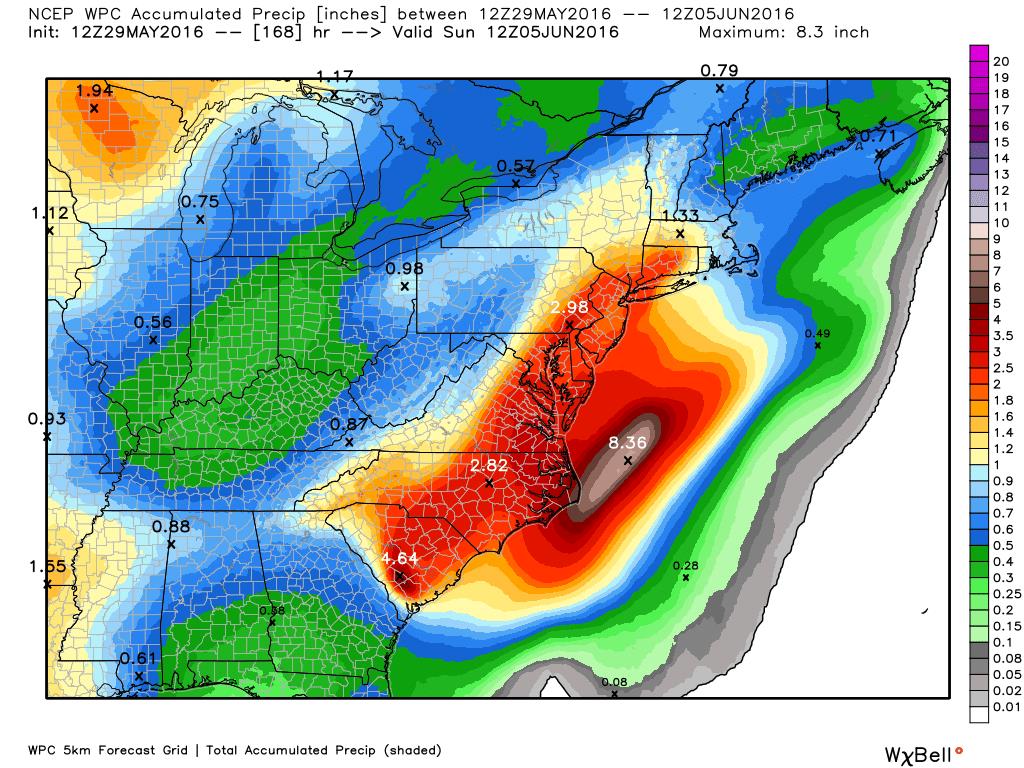
Forecast rainfall associated with Tropical Storm Bonnie
Tim Greene, Summit Intern

Seek the Peak Spotlight: The Cloud Chasers
Seek the Peak Spotlight: The Cloud Chasers By MWOBS Staff Mike Bergeron and Desiree Bolton have been participating and volunteering for Seek the Peak for three years now. Together, they comprise Team Cloud Chasers

Celebrating 250 Years: The Declaration’s Legacy in the White Mountains
Celebrating 250 Years: The Declaration's Legacy in the White Mountains By Peter Crane We are now approaching July Fourth, Independence Day, the day when we celebrate the adoption of the Declaration of Independence in

Seek the Peak Spotlight: Ryan Shepard
Seek the Peak Spotlight: Ryan Shepard By MWOBS Staff Before Ryan Shepard moved to Conway, he was in Western New York celebrating his 40th birthday party. “I wanted to go big,” he said. “Big”
