
New Personal Wind Record!
2019-04-16 20:14:03.000 – Ian Bailey, Weather Observer/Education Specialist
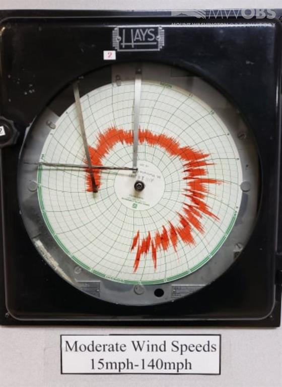
We had a pretty exciting night here on the summit last night! Most of us set new personal wind records, with a maximum verified gust of 142 mph! It was a long night of deicing and monitoring the Hays Chart, and we did not expect it to get anywhere near as fast as it did!
Looking back on what lead up to the event, I can’t help but laugh. As a crew, we were sitting around the dinner table last night commenting on how fast we thought the maximum gust was going to be. Our volunteer John Donovan set the rules for the “wager”, and was the first to call out a speed of 108 mph. The rest of us put out numbers like 111, 117 and 118. I recall feeling pretty confident in my bet, having just forecasted for the evening not but an hour before. I could see the ingredients coming together for a 110-120 mph event, but clearly couldn’t piece together that it would be much more intense.
So what was I seeing in the forecast? It was a combination of 3 main things. First was the big chonker of a low pressure in our proximity, as shown below:
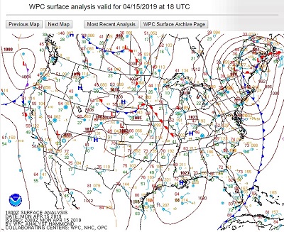
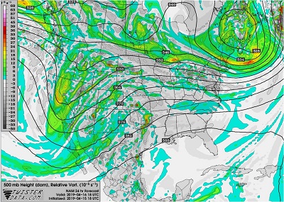
Then, when I went to look at the upper atmosphere, the models indicated what we call a “vorticity bullseye”, or a region of elevated vorticity, directly overhead. Vorticity is a fancy term for rotation in the upper atmosphere, which can lead to instability and turbulence that translates down to the surface. So not only was there fast horizontal movement, there was movement through an unstable atmosphere as well.
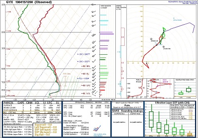
Finally, when I checked out a sounding for the region around the low, I saw the definitive proof for high winds. The red and green lines on this chart indicate a temperature profile and dew point profile respectively. As the lines move to the right of the chart, they are indicating warmer temperatures. And as they move to the left, they indicate colder temperatures. Now, generally speaking, temperature decreases with height. When the opposite is true, and temperatures are increasing with height, that is known as an inversion.
Inversions, which are great “stable” layers in the atmosphere, act like a lid for air movement below it. It takes a lot of force and lifting to break through that lid, and usually the inversion instead acts as a sort of compression down on the air underneath it. We are no strangers to the effects of compression here on Mt. Washington, and we know these capping lids force an acceleration in the winds that move across the top of the mountain. As you can see in the image above, we had a pretty sizable inversion sitting right at the level of the atmosphere where the summit resides. So, we were situated in the quadrant of the low with the fastest moving air, underneath and unstable environment, with a strong inversion right above us. With these 3 ingredients combined, I knew it was going to be a 100+ mph night.
But apparently I underestimated how much of a true impact this atmospheric setup would have, because as we now know, the winds were way higher than what we expected!
Unfortunately, I was downstairs asleep for the first half of the insanity. But the rest of my crew decided to forgo sleep to witness the craziness! John stayed up late, monitoring the first half of the night as the Hays Chart climbed higher and higher. He definitely set a new peak wind speed, and was very excited to have been up for it!
Jay and Adam, while both very excited about the crazy winds, were working their tails off to keep the instruments and ice under control. Along with the winds, the summit was experiencing some incredibly intense icing as well. According to them, they would clear the parapet of ice, come back downstairs, and then turn around to go back at it 10 minutes later. Adam noted that the ice was accruing as fast as 10-12 inches per hour! That’s bonkers…
All night long they battled the crazy ice. And when the peak 142 came in at 4:15 am, they was much, albeit exhausted, rejoicing! Even once I was awake at 6, winds were still gusting to 140 mph and the icing was really bad! So don’t worry, I got to join in on the fun too! The crazy speeds didn’t really slow down until later in the morning, and by slow down I mean only gusting to 110 mph. As you can see by the most recent look at the current Hays chart, we’ve been gusting over 100 all day! And as we talked about at dinner tonight, it was a welcome change from the relatively calm shifts we’ve had for the last month or so. Overall, it has been a very exciting day!
Ian Bailey, Weather Observer/Education Specialist

Seek the Peak Spotlight: The Cloud Chasers
Seek the Peak Spotlight: The Cloud Chasers By MWOBS Staff Mike Bergeron and Desiree Bolton have been participating and volunteering for Seek the Peak for three years now. Together, they comprise Team Cloud Chasers

Celebrating 250 Years: The Declaration’s Legacy in the White Mountains
Celebrating 250 Years: The Declaration's Legacy in the White Mountains By Peter Crane We are now approaching July Fourth, Independence Day, the day when we celebrate the adoption of the Declaration of Independence in

Seek the Peak Spotlight: Ryan Shepard
Seek the Peak Spotlight: Ryan Shepard By MWOBS Staff Before Ryan Shepard moved to Conway, he was in Western New York celebrating his 40th birthday party. “I wanted to go big,” he said. “Big”
