
NULL
2010-05-01 14:31:18.000 – Stacey Kawecki, Observer and Meteorologist
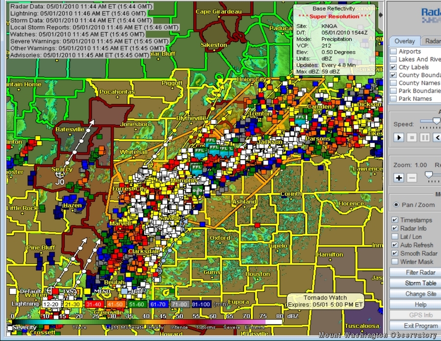
That’s a good-looking radar!
Happy May Day Observatory website visitors! The summit is celebrating in a rather quiet fashion. Temperature is a balmy 38 degrees, winds are a merely 35-40 mph and the violently blowing snow…well there’s not much left. The intense winter-storm is over, and we can see rocks and sedge again. In fact (even though I’m not the gambling type), I’ll wager that by the time we leave the mountain (in a week), most of the snow will be gone. According to the models, we’ll dip below freezing on Wednesday, but should be in the clear for that. Not until next Saturday are temperatures forecast to drop below the freezing mark with fog.
In my relentless weather vigilance, I have been keeping an eye on the storms in the mid-west. There is some incredible convective action centered around the junction of the Ohio and Mississippi River valleys. The Storm Prediction Center claims there is a high risk for severe weather in this area. The atmospheric variables favor the creation of supercell thunderstorms with rotation. There are more than a few ingredients in the recipe for severe weather and a lot of them are in the mixing bowl: moisture, warmth, lifting mechanism, vertical wind shear (directional and velocity). Right now moisture is being funneled into the Gulf States and northward by a fairly strong wind at the 850 mb level. In addition to the moist air, the Gulf of Mexico is warm! So, warmth and moisture are flowing along this wind. To the west, there is a slow-moving frontal system, characterized primarily by a much cooler and drier air mass. That advancing cold air will push the warm, moist air up, creating convective clouds. That is the lifting mechanism. Add a dash of vertical wind shear: at 850 mb, winds are from the south, at 500 mb winds are from the southwest. Also, the radar looks amazing.
As that low slowly makes its way east, the northern New England area could be seeing some leftover thunderstorms tomorrow! 2 feet of snow followed quickly by the chance for some rumbles? Mount Washington sure does keep its weather observers on their toes!
Stacey Kawecki, Observer and Meteorologist

Seek the Peak 2026: New Adventures, Rooted in Tradition
Seek the Peak 2026: New Adventures, Rooted in Tradition By MWOBS Staff Seek the Peak is Mount Washington Observatory's largest annual fundraiser, and for 26 years it's brought together hikers, adventurers, and people who

What “Prepared” Really Means in the White Mountains
What “Prepared” Really Means in the White Mountains Early Spring in the Whites: The Most Honest Season By Andrew Harris, Burgeon Outdoor If you’ve spent any time in New Hampshire’s White Mountains in March,

March on Mount Washington
March on Mount Washington By Ryan Knapp Looking towards Mt. Madison at sunset on March 21, 2026. The calendar has spoken: Friday, 20 March 2026, marked the first day of astronomical spring.
