NULL
2008-10-28 22:44:33.000 – Ryan Knapp, Staff Meteorologist
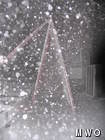
Our A-frame with some falling snow.
Today, we got a lot of calls about what the weather was doing up here. Since no one has written a comment for today, I will post something really quick about what has happened so far:
A coastal low deepened and intensified as it made its way northward through Connecticut, up through Vermont and now over southeastern Quebec. Pressure fell through the day to a reading of 22.939 inches Hg as of 2200 EST tonight. This area of low pressure is bringing the first significant winter storm for most of the northeast. If you had been up here over the last 24 hours, you would have seen a summit transformed. From midnight last night until about 0500 EST, the summits were out of the fog with a complete undercast and not a patch of snow/ice/rime anywhere. We were an island above the clouds under starry skies. Fog rolled back in and has held its grip since then.
Some drizzle was first to grace the summits at 0735 EST this morning. The precipitation did not really get going until 1040 EST though as a mixed bag of rain, snow and ice pellets started falling. Through the day, the summits continued to receive mixed precipitation in the form of rain, snow, sleet, snow grains, and ice pellets. This stratified the ground up here with a layer of snow and ice pellets, then a layer of freezing rain freezing it in place then another layer of ice pellets and snow grains making for a dense layer and now snow on top drifting and blowing freely creating near white out conditions. There is nearly 2-3” of frozen precipitation on the summit with much deeper drifts. Glaze icing coated everything at first but has since switched over to rime ice.
We even got two flashes of lightning at 1758 and 1759 EST this evening. I have heard of thunder snow but never thunder sleet. Winds have so far peaked at 73 mph but we are expecting higher as the night rolls on. Winds are expected to pick up and with how deep this low is, as it departs with a steep gradient, winds will probably gust just shy of 100 mph. Temperatures are currently 23F and slowly falling and are expected to continue to fall through early Thursday morning. Temperatures are expected to fall low enough that the 29th or 30th may see new daily record lows (the other shift will have to let you know though since I am heading down tomorrow). For the rest of the night, we will continue to see precipitation, mostly in the form of snow as temperatures continue to fall. So looks like a busy night ahead. So, as I return to work, here are some pictures I snapped tonight.
Snow covered cog tracks.
State Parks front entrance.
A pile of snow on the deck next to the former COSMO shack.
SE view of our wind instruments.
NE view of our wind instruments.
Up close and personal with our pitot-tube static anemometer.
Same view of the “pitot” but a different shutter speed.Isn’t it amazing how changing a camera speed can make 25 mph winds look like hurricane force winds.
Ryan Knapp, Staff Meteorologist
Three and a Half Months of Snow, Ice and Rime
Three and a Half Months of Snow, Ice and Rime, with Deeper Drifts. By Ryan Steinke Me outside on the summit near the Yankee Building. My internship with the Mount Washington Observatory
Supporter Spotlight: Righteous Vices Coffee Roasters
Supporter Spotlight: Righteous Vices Coffee Roasters By MWOBS Staff Righteous Vices Coffee Roasters, a local coffee roaster and shop located in Center Conway, New Hampshire, has been a partner of the Observatory since 2024.
Winter Storm Tracks Across New Hampshire
Winter Storm Tracks Across New Hampshire By Alex Branton As winter comes to a close, most of us are ready for the warmer temperatures and sunshine that come with Spring and Summer. Although we


