
NULL
2007-06-29 06:00:25.000 – Kyle Paddleford, Meteorologist

Just getting started
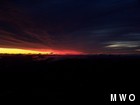
I can’t believe my eyes! A few days ago visibility was only ten to twenty miles due to thick haze and moisture in the air. Now I can see over eighty miles and clearly pick out land marks such as Mt. Mansfield, Camels Hump, and Jay Peak in Vermont. There is no doubt many of you have already felt the difference, as a much cooler and drier airmass is now in place over the region.
I was getting ready for bed after working the night shift just prior to the cold front pushing through yesterday morning. Glancing at the radar I decided to hold off for a little while longer and go up to the weather room to witness the storm passing just to our north. As Ken had mentioned in yesterdays comment, we had an 83 mph wind gust and .47 inches of rain in a very short period of time. The wind gust shows up really well on our Hayes chart as the big red spike. I have made other comparisons in previous comments to the summit and an island, or a ship in the middle of the ocean and this is no different. The heavy wind driven rain reminded me of the crashing waves of a turbulent sea on a rocky coastline. There was so much water being blown over the rocks for an instant I swear I saw white caps. It was neat, you could actually see how the air was flowing over obstacles and interacting with every feature it would encounter.
Last night was pretty uneventful and very routine with fog observations all night long. However, the temperature came very close to hitting the freezing mark. I guess we will have to wait until tomorrow night for a chance of icing. I must say though, I have had great company so far this week during the long nights. It’s always good to have a friend around.
Well, I was treated to quite the storm Thursday morning, and today an amazing sunrise with great visibilities. I wonder what’s in store for tomorrow morning? With the way the weather changes up here, it could be almost anything.
Do you know what to do if you get caught in a Thunderstorm? The reason I ask is to point out that it is National Lightning Safety Awareness Week. With all the severe storms we have had over the last few weeks it is a good time to become more aware of the hazards of lightning. Outreach Educator Michelle Cruz will present the best methods for keeping yourself safe from lightning strikes whether you are indoors our outside, as well as discussing statistics, facts, and myths. The presentation will be free and happen this Saturday at 12 Noon, 1:30 PM, and 3 PM at the Weather Discovery Center Located on Main Street in North Conway village.
Kyle Paddleford, Meteorologist

From Florida Heat to the Rockpile
From Florida Heat to the Rockpile By Alek Libby Hi everyone! My name is Alek Libby, and I am one of the summit interns here at Mount Washington Observatory this summer! I recently graduated
Summit Summer
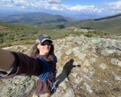
Summit Summer By Aspen M. Hello everyone! My name is Aspen, I’m one of the summer weather interns here at the Mount Washington Observatory. I fell in love with weather at a young age
From the Sunshine State to the Home of the World’s Weather
From the Sunshine State to the Home of the World's Weather By Kristen Mihalcik Hello Everyone! My name is Kristen Mihalcik, and I’m one of the Summer interns here at Mount Washington. Enjoying
