
NULL
2007-04-03 09:01:54.000 – Jim Salge, Observer

Presidentials Window
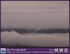
Considering that we had April in early January, it’s only fair that we get a bit of January in April. Light snow moved in yesterday, and combined with some rather heavy rime and glaze icing, has re-flocked the mountain in a showy winter coat. Visibility on the summit is limiting the ability to take a picture of the new snow for the website, so we’ll leave it to the webcams today. This shot, one of the more unique I’ve seen, was taken from the new Presidentials cam this morning. It shows the new snow level, fairly down on the peak through a window in the clouds.
And the snow continues this morning. And the snow will continue every day for the remainder of the week. The biggest weather excitement surrounds the latest model run, showing a large storm system trending colder over the White Mountains Region tomorrow night into Thursday. Temperatures look borderline at the onset, but a steady wedge of cold air moving in during the event could give this peak a healthy snow dose.
Lastly this morning, I’ll provide a link to an article that ran a few days ago in the Concord Monitor. Reporter/Photographer Lori Duff came up on an Edutrip in March, and has a spectacular slideshow of her impressions of the mountain. See the slideshow here.
Jim Salge, Observer
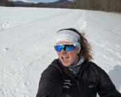
Home Sweet Summit
Home Sweet Summit By Kathryn Hawkes Me enjoying the view of Mount Washington while skiing in the valley on my off week. Hi everyone! My name is Kathryn Hawkes and I’m the

Meet MWOBS/MWAC Intern Ryan Tanski
Meet MWOBS/MWAC Intern Ryan Tanski By Ryan Tanski Hello! I’m Ryan Tanski and I’m the joint USFS Mount Washington Avalanche Center and Mount Washington Observatory Intern this winter. I’m thrilled to get to work

Geologist Climbs Rock Pile, Looks Up
Geologist Climbs Rock Pile, Looks Up By Bailey Nordin Hello from the summit of Mount Washington! My name is Bailey Nordin, and I am the newest Weather Observer and Education Specialist joining the team
