October Orographic Uplift
2012-10-01 18:12:12.000 – Brian Fitzgerald, Weather Observer/Education Specialist
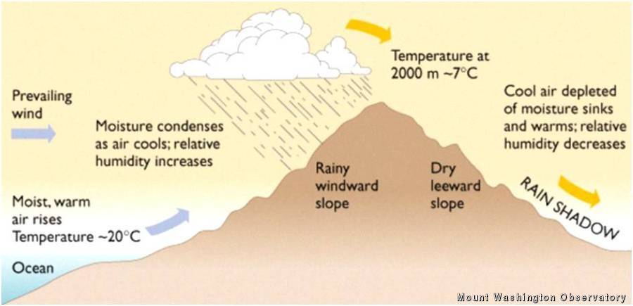
Diagram of Orographic Uplift
Happy October! It was quite the surprise to wake up to a blanketed-white summit and snow flakes flying. While a slight chance for mixed precipitation showers were in the forecast for today, it’s always a pleasant surprise when you wake up to a new day and month.
The white stuff made a transition to rain by late in the morning as low pressure moved offshore, though not quite taking all the rain with it. As most of the rain in the region tapered off, steady light rain showers refused to leave the radar over the White Mountains, and more specifically right over our station, leading at least one observer to make the comment, ‘Ah, upslope showers.’ What is an upslope shower though? Certainly in my time as a hiker, intern and observer I’ve heard the term upslope showers being thrown around and wondered why Mount Washington was plagued by this.
Essentially, when we talk about upslope showers, we’re talking about precipitation that is being formed by the size and shape of the mountain itself. Mount Washington is not the only mountain in the world that experiences this effect, but nearly every topographically-prominent mountain contributes to something known as orographic lift. When moisture-rich air is pushed into and up the side of a mountain it cools and condenses into clouds and eventually falls as precipitation on the windward side of the slope. On the back-side, or lee-side of a mountain, the prevailing wind (the air that has risen cooled and condensed) on the windward side of the mountain will now begin to warm and dry, leaving what is known as a rainshadow. One of the best examples of this phenomena is the Tibetan Plateau in southwest China, where monsoon moisture from the Indian Ocean drops significant precipitation south of the Himalayas, leaving Tibet parched and dry.
While Mount Washington may not have the same towering stature of the Himalayas, we still experience significantly higher precipitation from areas as close as Pinkham Notch, where rain and snowfall amounts typically fall to about half of the summit’s total. This is just another reason why it’s critical for visitors of the summit to expect the unexpected when venturing above treeline.
Tomorrow, as moisture slowly leaves the region we can expect that upslope showers will dissipate and who knows, maybe the sun will make an appearance on high. I know my fingers are crossed.
For more information on the Mount Washington Observatory about events, information on becoming a member or local forecasts and outlooks, visit MountWashington.org .
Brian Fitzgerald, Weather Observer/Education Specialist
Three and a Half Months of Snow, Ice and Rime
Three and a Half Months of Snow, Ice and Rime, with Deeper Drifts. By Ryan Steinke Me outside on the summit near the Yankee Building. My internship with the Mount Washington Observatory
Supporter Spotlight: Righteous Vices Coffee Roasters
Supporter Spotlight: Righteous Vices Coffee Roasters By MWOBS Staff Righteous Vices Coffee Roasters, a local coffee roaster and shop located in Center Conway, New Hampshire, has been a partner of the Observatory since 2024.
Winter Storm Tracks Across New Hampshire
Winter Storm Tracks Across New Hampshire By Alex Branton As winter comes to a close, most of us are ready for the warmer temperatures and sunshine that come with Spring and Summer. Although we


