
Out of the Fridge…And Into the Freezer
2019-03-10 10:48:44.000 – Thomas Padham, Weather Observer/Education Specialist
After today’s Facebook Live forecast discussion I thought I’d take a little more of an expanded look at the longer range forecast for the majority of this month of March. March is commonly referenced to have weather “in like a lion, out like a lamb” as we progress out of the last hurrahs of winter and into spring. Things looks a bit more complicated than that as far as the longer range models are concerned.
Behind this storm system which will affect Mount Washington with 6-8” of snow and yet another round of 100+ mph winds, we’ll see another batch of cold air. We’ll likely bottom out just below zero on the summit early Tuesday, roughly 10-15°F below average for this time of year.
Then comes a brief, but significant warm up for the Northeast. Low pressure looks to rapidly develop over the central Plains Thursday, with a deep flow from the Gulf of Mexico surging ahead of the storm. The storm itself appears to mostly fall apart before reaching New England, with a light rainfall expected. The bigger story will be the very mild, spring like temperatures. Here on the summit we’ll be looking at the first 40+ degree readings of 2019, possibly reaching the mid or ever upper 40s. This combined with rainfall and summit fog will likely lead to a significant melt out. Readings in the valleys of New England will possibly reach 60°F Friday in a few spots, a welcome sign for many of our winter-weary residents!
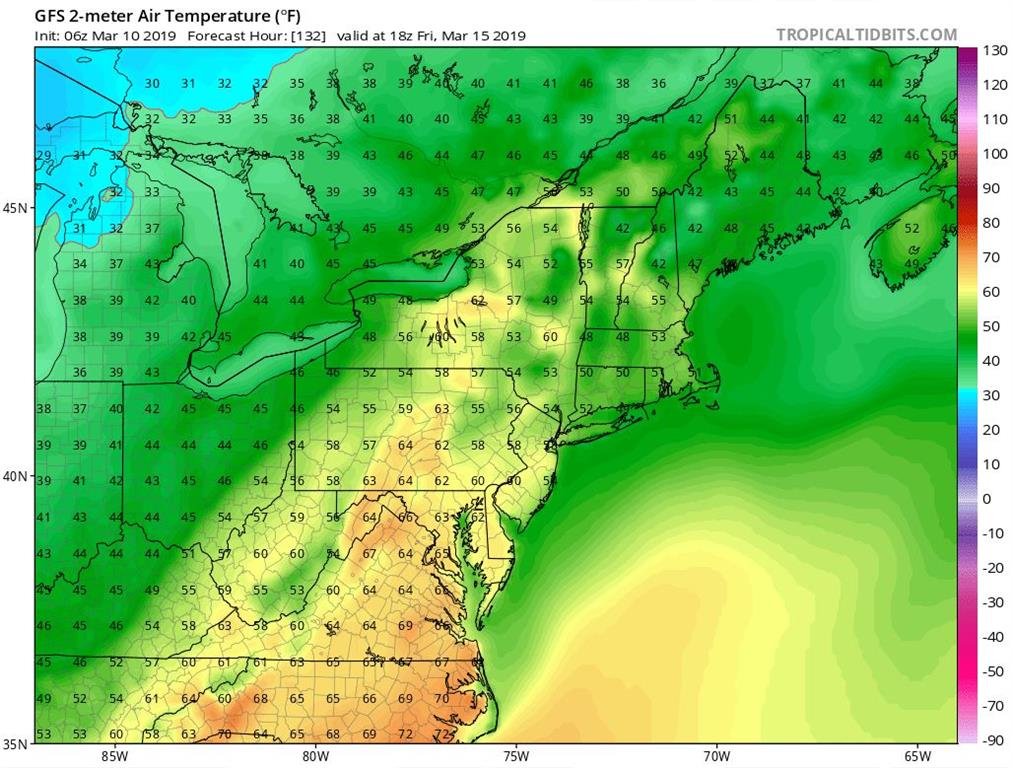 GFS model surface temperatures for Friday, March 15th showing very mild readings across the Northeast. Image courtesy of Tropical Tidbits.
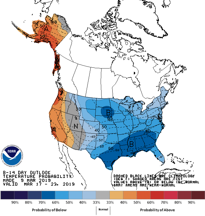
So should we break out the shorts and say goodbye to winter? Not quite yet. Especially for northern New England, all signs point towards below average temperatures for much of the remainder of March after this brief warm up Thursday-Friday. This looks most certain for the middle of the month, when the National Weather Service 8-14 day outlook has below average temperatures for the entire eastern 2/3rd of the country. On the summit there is no sign of any additional above freezing temperatures as far out as we can see. I’ll be looking forward to the brief taste of spring, but I’m also always in favor of some more snow and cold at the “Home of the World’s Worst Weather”!
Thomas Padham, Weather Observer/Education Specialist

Three and a Half Months of Snow, Ice and Rime
Three and a Half Months of Snow, Ice and Rime, with Deeper Drifts. By Ryan Steinke Me outside on the summit near the Yankee Building. My internship with the Mount Washington Observatory

Supporter Spotlight: Righteous Vices Coffee Roasters
Supporter Spotlight: Righteous Vices Coffee Roasters By MWOBS Staff Righteous Vices Coffee Roasters, a local coffee roaster and shop located in Center Conway, New Hampshire, has been a partner of the Observatory since 2024.

Winter Storm Tracks Across New Hampshire
Winter Storm Tracks Across New Hampshire By Alex Branton As winter comes to a close, most of us are ready for the warmer temperatures and sunshine that come with Spring and Summer. Although we
