Passing Storms
2010-05-25 16:42:09.000 – Mike Carmon, Staff Meteorologist
Missed it by that much…
I’m currently watching the sky to the northeast like a disappointed child who didn’t get what he wanted on Christmas.
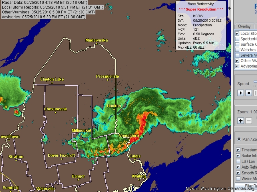
We were hoping for a few thunderstorms today to close out our shift with a bang, but it looks like our neighbors to the east, Maine and Canada, are getting all the action. The radar from out there is lit up with bright reds and oranges.
The storms are so massive that the cirrus tops of the cumulonimbus clouds can be seen from here on the summit. A few towering cumulus are becoming faintly visible on the horizon, but as of now, all of the exciting stuff is passing to our east. There is still a bit of hope, though–as the cold front draws closer to the summit, the mountains could aid in firing a few isolated cells. We’ll just have to wait and see. At the very least, as a second round of storms drops down (which is a bit further west, just barely visible on the far left of the radar image above), we should be able to witness some distant lightning as the sun wanes on the opposite side of the horizon.
In the meantime, winds are picking up, more shallow cumulus clouds are beginning to litter the skies, and temperatures are still hovering above 60 degrees. The daily record high for today was 61 degrees, and it was comfortably broken, as the mercury climbed to 65 degrees today–just 1 degree shy of the all-time record high of 66 degrees for the month of May. It’s quite the swelter out there!
Mike Carmon, Staff Meteorologist
Three and a Half Months of Snow, Ice and Rime
Three and a Half Months of Snow, Ice and Rime, with Deeper Drifts. By Ryan Steinke Me outside on the summit near the Yankee Building. My internship with the Mount Washington Observatory
Supporter Spotlight: Righteous Vices Coffee Roasters
Supporter Spotlight: Righteous Vices Coffee Roasters By MWOBS Staff Righteous Vices Coffee Roasters, a local coffee roaster and shop located in Center Conway, New Hampshire, has been a partner of the Observatory since 2024.
Winter Storm Tracks Across New Hampshire
Winter Storm Tracks Across New Hampshire By Alex Branton As winter comes to a close, most of us are ready for the warmer temperatures and sunshine that come with Spring and Summer. Although we


