Precipitation Type Forecasting
2012-12-16 23:22:32.000 – Mike Carmon, Weather Observer/Meteorologist
Tuesday’s Culprit
Although forecasting is an enjoyable challenge for me, when it comes to matters such as precipitation type forecasting, things can get decidedly dicey. Even though computer models do reasonably well with predicting temperatures, a degree or two can make all the difference in determining an all-snow event vs. a freezing rain event vs. an all-rain event.
Last night (and most likely tonight) was (will be) one of those especially tricky situations, and gave (will give) my forecasting prowess a run for its money.
The day in question in tonight’s forecast: Tuesday.
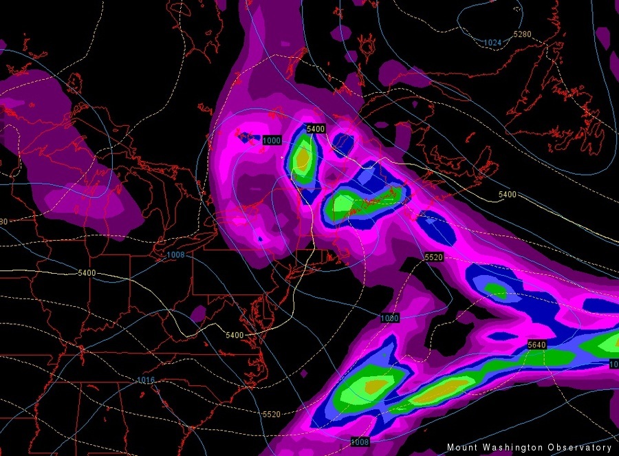
The big-picture: A low pressure system will develop over the Ohio Valley on Monday and trek east-northeastwards toward the eastern seaboard. This will place much of New England in its warm sector, most likely resulting in a primarily rain event for most of the region.
Zooming in: Model numbers have us lingering in the upper 20s F for most of the day on the summit on Tuesday, with a high of about 30F, with moderate to heavy precipitation falling for most of the day.
What my experience tells me: In this range of temperatures, without looking at the bigger picture, a wintry mix of precipitation is a good possibility, at least periodically through the event.
What the “big picture”, stated above, tells me: In a warm air advection event, meaning an event in which warm air moves in to supplant cold air already in place, generally precipitation begins colder (snow, sleet, etc.) and trends towards warmer types (freezing rain, rain) as the warmer air mixes down from the upper-levels to the surface.
Another factor to consider: Initialization of the computer models. A forecaster must consider how the models are verifying at the present time, and adjust the future numbers accordingly. For example, if the models were predicting a temperature around 20F for the 6-9 hours prior to forecasting, and the actual outdoor temperature during that time was more like 24F, a forecaster should consider that the models are running consistently cold, and add a couple of degrees to the predictions for the following few hours. Over the past day or so, the models have been running a few degrees too cold, so I might consider adding three to four degrees to the official temperature forecast.
What that extra degree or two means: A high of 29F vs. 33F could make all the difference in the world when it comes to whether there will be a significant freezing rain event (29F) or an event featuring plain rain at times (33F). Of course, the temperature at the surface is not the only factor in determining precipitation type; not at all.
What temperatures above tell me: Looking at a vertical profile of forecasted temperatures is a very critical tool in determining precipitation type. While temperatures could be below freezing at the surface, differences in wind speeds and directions at different heights of the atmosphere very often allow for temperatures above the surface to warm above freezing before the surface does. A warm pocket above the surface could be deep enough to melt any snow falling from above. If a relatively shallow cold layer exists beneath that warm layer, keeping surface temperatures below freezing, the melted snow (rain) will freeze on contact, resulting in a freezing rain event. If the cold layer is a bit deeper, the melted snow (rain) will have a longer path through sub-freezing temperatures, giving it a chance to re-freeze into ice pellets (sleet).
I’ll be delving much further into these issues, and more, tonight (Sunday night), and I am very much looking forward to the challenge! What will I ultimately conclude? Well, you can check that out by looking at the higher summits forecast page here.
Mike Carmon, Weather Observer/Meteorologist
Three and a Half Months of Snow, Ice and Rime
Three and a Half Months of Snow, Ice and Rime, with Deeper Drifts. By Ryan Steinke Me outside on the summit near the Yankee Building. My internship with the Mount Washington Observatory
Supporter Spotlight: Righteous Vices Coffee Roasters
Supporter Spotlight: Righteous Vices Coffee Roasters By MWOBS Staff Righteous Vices Coffee Roasters, a local coffee roaster and shop located in Center Conway, New Hampshire, has been a partner of the Observatory since 2024.
Winter Storm Tracks Across New Hampshire
Winter Storm Tracks Across New Hampshire By Alex Branton As winter comes to a close, most of us are ready for the warmer temperatures and sunshine that come with Spring and Summer. Although we


