
Predicting Snowfall
2013-02-07 18:34:49.000 – Mike Dorfman, Summit Intern

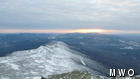
Cloud Cover Begins to Increase Ahead of the Storm
What tools do we use up here to determine how much snow might fall in a storm? There are many different models which are able to predict how much liquid precipitation may fall from a storm, however this cannot be automatically translated directly to snow depth. The water to snow ratio is determined by several factors, including humidity and temperature and crystal size and shape.
One of the best tools for snow prediction that I have been shown during my internship on the summit is the Hydometeorological Prediction Center’s winter weather maps. Instead of pinning certain numbers for snow total predictions to certain places, these maps show the (un)certainty in the models. It is inherently incorrect to say ‘Boston is going to get X inches of snow’, as there is always uncertainty involved in this prediction. With HPC’s winter forecasting maps, you can understand the extent of this uncertainty.
Now, one may ask ‘why do we even have meteorologists if computers can do all the work?’ Models are not always correct. Upon waking up the other day, I saw a snow total map of New England for the upcoming storm that included predicted snowfall of 5.5 feet. Before deciding whether I should jump for joy or be concerned, I consulted our staff meteorologist. Certain models are more accurate in some situations than others, and I had glanced at one that typically does not track Nor’easters very well. After taking a look at some other maps, I had a more realistic understanding of what to expect for snow totals. It takes both knowledge of the biases of certain models and understanding of what’s happening in our atmosphere to accurately forecast weather. It is therefore impossible for a computer to predict weather more accurately than the combination of a computer and human.
Mike Dorfman, Summit Intern

Seek the Peak Spotlight: The Cloud Chasers
Seek the Peak Spotlight: The Cloud Chasers By MWOBS Staff Mike Bergeron and Desiree Bolton have been participating and volunteering for Seek the Peak for three years now. Together, they comprise Team Cloud Chasers

Celebrating 250 Years: The Declaration’s Legacy in the White Mountains
Celebrating 250 Years: The Declaration's Legacy in the White Mountains By Peter Crane We are now approaching July Fourth, Independence Day, the day when we celebrate the adoption of the Declaration of Independence in

Seek the Peak Spotlight: Ryan Shepard
Seek the Peak Spotlight: Ryan Shepard By MWOBS Staff Before Ryan Shepard moved to Conway, he was in Western New York celebrating his 40th birthday party. “I wanted to go big,” he said. “Big”
