Predicting Weather From the Clouds
2012-09-21 19:46:42.000 – Mike Dorfman, Summit Intern
NULL
Many hikers coming out to the White Mountains have the opportunity to check weather reports on a daily basis thanks to the many huts that display the higher summits forecast. There are many places, both in the northeast and other parts of the country, where hikers can go for days or even weeks without being in touch with front-country luxuries such as a weather forecast. Without these forecasts and warnings, many backpackers can be caught off guard by severe weather. Backcountry travelers may not have access to a forecast, but cloud types can sometimes indicate whether the day should be weathered out in the tent or if it’s safe to venture above tree line.
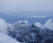
One indicator that rain may be approaching is the presence of growing lenticular clouds. These clouds look like ‘caps’ on top of mountains, hovering over mountaintops. They form when air rises over a mountain and condenses near the top of the mountain as it cools. This is showing that the air flowing over the mountain is very moist and if this cap grows, you know the air is growing moister. Eventually, stratus and other clouds will start to form in the sky and soon rain might be falling.
Often in the summertime, the biggest meteorological threat is by thunderstorms. Summertime thunderstorms require several things to form; they need moist air, a source of heat, and an unstable atmosphere. If you look up to the sky on a summer morning and see towering, growing cumulus clouds above you, it is a good indicator that you could run into heavy rain and thunderstorms later in the day.
Another good indicator as to what the weather will do is not by looking at natural clouds, but rather by looking at contrails of airplanes. As airplanes move through the air, the immense pressurization then subsequent depressurization as air flows over the wing of an aircraft forces water inside the air to condense. Often, the air surrounding this small ‘cloud’ is very dry, so the water droplets immediately evaporate back into the dry air. However if contrails stick around for a long time, then the surrounding air may be moist. If you see these contrails lingering for longer and longer, showing the air becoming more and more moist, then you know clouds may soon form above you!
The key to backcountry travel in exposed areas is to start early and be flexible. If you start early, then you are almost sure to beat any convective storms that often form later in the day. Keep your eyes open and, look for clouds that could indicate foul weather is on its way and act accordingly!
Mike Dorfman, Summit Intern
Seek the Peak 2026: New Adventures, Rooted in Tradition
Seek the Peak 2026: New Adventures, Rooted in Tradition By MWOBS Staff Seek the Peak is Mount Washington Observatory's largest annual fundraiser, and for 26 years it's brought together hikers, adventurers, and people who
What “Prepared” Really Means in the White Mountains
What “Prepared” Really Means in the White Mountains Early Spring in the Whites: The Most Honest Season By Andrew Harris, Burgeon Outdoor If you’ve spent any time in New Hampshire’s White Mountains in March,
March on Mount Washington
March on Mount Washington By Ryan Knapp Looking towards Mt. Madison at sunset on March 21, 2026. The calendar has spoken: Friday, 20 March 2026, marked the first day of astronomical spring.


